File:Gambia satellite fires.jpeg
Jump to navigation
Jump to search
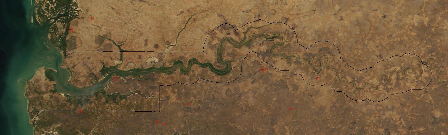
Size of this preview: 800 × 242 pixels. Other resolutions: 320 × 97 pixels | 1,432 × 433 pixels.
Original file (1,432 × 433 pixels, file size: 103 KB, MIME type: image/jpeg)
Captions
Captions
Add a one-line explanation of what this file represents
Summary[edit]
| Description |
Image cropped to The Gambia. The red dots sprinkled all across this true-color image show the locations of fires mostly located in the African savannas just south of the Sahel region. Many fires were burning in this region throughout February 2002. This scene was acquired by the Moderate-resolution Imaging Spectroradiometer (MODIS), flying aboard NASA's Terra satellite, on Feb. 15. |
| Date | |
| Source | Cropped from: http://visibleearth.nasa.gov/view_rec.php?id=2521 |
| Author | Jacques Descloitres, MODIS Land Rapid Response Team at NASA GSFC |
| Other versions | Image:Senegal satellite fires.jpeg |
Licensing[edit]
| This file is in the public domain in the United States because it was solely created by NASA. NASA copyright policy states that "NASA material is not protected by copyright unless noted". (See Template:PD-USGov, NASA copyright policy page or JPL Image Use Policy.) | ||
 |
Warnings:
|
File history
Click on a date/time to view the file as it appeared at that time.
| Date/Time | Thumbnail | Dimensions | User | Comment | |
|---|---|---|---|---|---|
| current | 18:11, 20 December 2004 | 1,432 × 433 (103 KB) | Ikiwaner (talk | contribs) | Map from [http://visibleearth.nasa.gov/cgi-bin/viewrecord?12145 NASA Visible Earth] {{PD-USGov-NASA}} |
You cannot overwrite this file.
File usage on Commons
The following page uses this file:
File usage on other wikis
The following other wikis use this file:
- Usage on af.wikipedia.org
- Usage on ar.wikipedia.org
- Usage on ca.wikipedia.org
- Usage on cs.wikipedia.org
- Usage on cv.wikipedia.org
- Usage on da.wikipedia.org
- Usage on de.wikipedia.org
- Usage on en.wikipedia.org
- Usage on eo.wikipedia.org
- Usage on es.wikipedia.org
- Usage on fi.wikipedia.org
- Usage on frr.wikipedia.org
- Usage on fr.wikipedia.org
- Usage on ha.wikipedia.org
- Usage on he.wikipedia.org
- Usage on ja.wikipedia.org
- Usage on jv.wikipedia.org
- Usage on mk.wikipedia.org
- Usage on ms.wikipedia.org
- Usage on nl.wikipedia.org
- Usage on nn.wikipedia.org
- Usage on pt.wikipedia.org
- Usage on ru.wikipedia.org
- Usage on sv.wikipedia.org
- Usage on sw.wikipedia.org
- Usage on uk.wikipedia.org
- Usage on vi.wikipedia.org
- Usage on wo.wikipedia.org
- Usage on xmf.wikipedia.org
- Usage on zh.wikipedia.org