File:Gammelgarns kyrka och kastal.jpg
Original file (2,903 × 2,459 pixels, file size: 7.57 MB, MIME type: image/jpeg)
Captions
Summary
[edit]DescriptionGammelgarns kyrka och kastal.jpg |
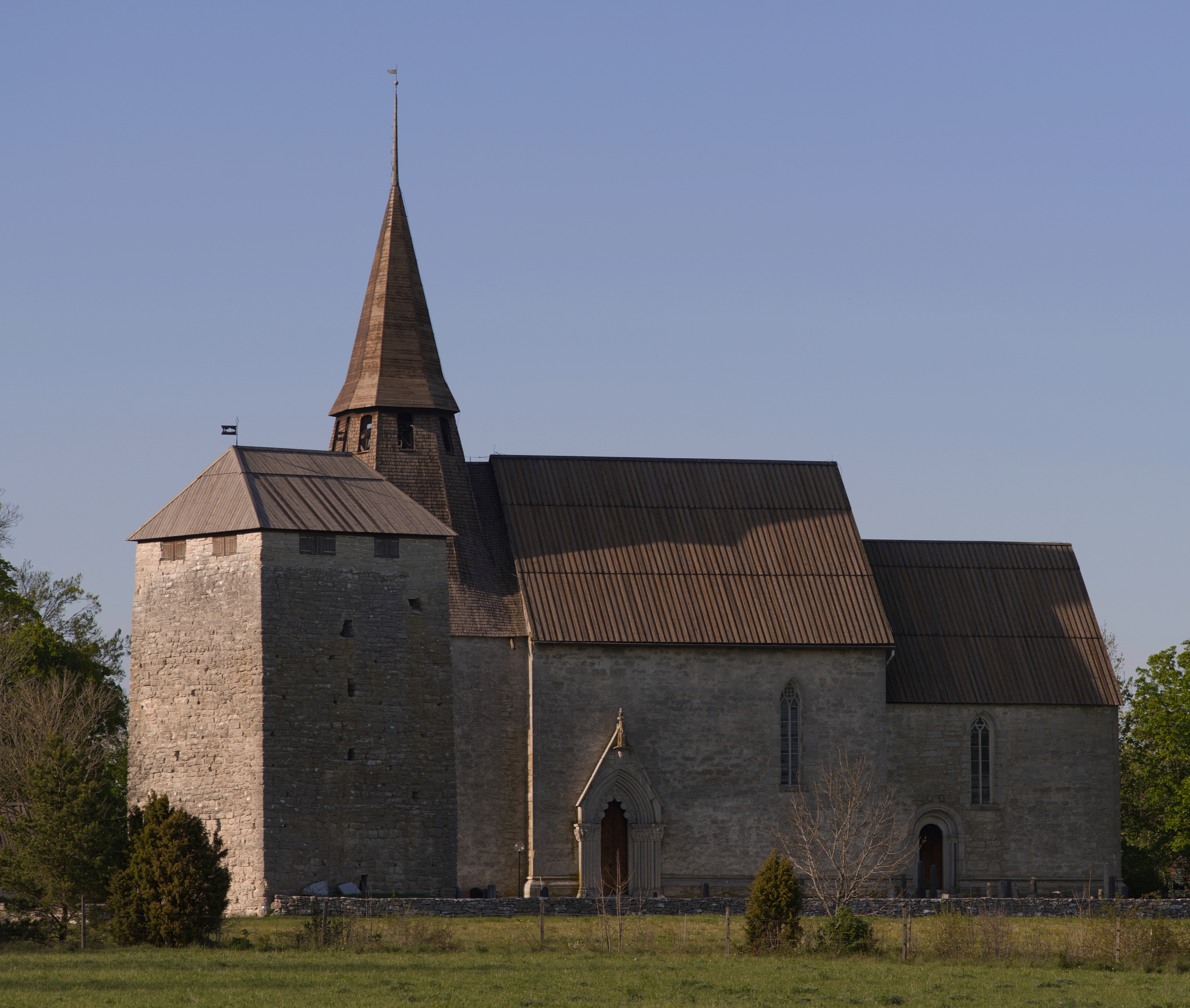
Svenska: Kastalen t v är en försvarsanläggning omedelbart intill kyrkobyggnaden. Försvarsändamålet syns även i kyrkans utformning. Byggnaderna har medeltida ursprung och medeltida karaktär även om byggnadshistoriken är lång och komplicerad.
|
||
Date | |||
Source | Own work | ||
Author | Måns Hagberg |
Camera location | 57° 24′ 08.99″ N, 18° 48′ 12″ E | View this and other nearby images on: OpenStreetMap | 57.402497; 18.803333 |
---|
This image was uploaded as part of Wiki Loves Monuments 2023.
Afrikaans ∙ Alemannisch ∙ azərbaycanca ∙ Bahasa Indonesia ∙ Bahasa Melayu ∙ Bikol Central ∙ bosanski ∙ brezhoneg ∙ català ∙ čeština ∙ Cymraeg ∙ dansk ∙ davvisámegiella ∙ Deutsch ∙ eesti ∙ English ∙ español ∙ Esperanto ∙ euskara ∙ français ∙ Frysk ∙ Gaeilge ∙ galego ∙ hrvatski ∙ Ido ∙ italiano ∙ latviešu ∙ Lëtzebuergesch ∙ Malagasy ∙ magyar ∙ Malti ∙ Nederlands ∙ norsk ∙ norsk nynorsk ∙ norsk bokmål ∙ oʻzbekcha ∙ polski ∙ português ∙ português do Brasil ∙ română ∙ shqip ∙ sicilianu ∙ slovenčina ∙ slovenščina ∙ suomi ∙ svenska ∙ Tagalog ∙ Türkçe ∙ Yorùbá ∙ Zazaki ∙ Ελληνικά ∙ беларуская ∙ беларуская (тарашкевіца) ∙ български ∙ кыргызча ∙ македонски ∙ русский ∙ српски / srpski ∙ українська ∙ ქართული ∙ հայերեն ∙ नेपाली ∙ हिन्दी ∙ বাংলা ∙ മലയാളം ∙ ไทย ∙ 한국어 ∙ 中文 ∙ +/− |
Licensing
[edit]- You are free:
- to share – to copy, distribute and transmit the work
- to remix – to adapt the work
- Under the following conditions:
- attribution – You must give appropriate credit, provide a link to the license, and indicate if changes were made. You may do so in any reasonable manner, but not in any way that suggests the licensor endorses you or your use.
- share alike – If you remix, transform, or build upon the material, you must distribute your contributions under the same or compatible license as the original.
File history
Click on a date/time to view the file as it appeared at that time.
Date/Time | Thumbnail | Dimensions | User | Comment | |
---|---|---|---|---|---|
current | 21:53, 28 September 2023 | 2,903 × 2,459 (7.57 MB) | Magnus 0038 (talk | contribs) | Uploaded own work with UploadWizard |
You cannot overwrite this file.
File usage on Commons
The following page uses this file:
Metadata
This file contains additional information such as Exif metadata which may have been added by the digital camera, scanner, or software program used to create or digitize it. If the file has been modified from its original state, some details such as the timestamp may not fully reflect those of the original file. The timestamp is only as accurate as the clock in the camera, and it may be completely wrong.
Camera manufacturer | RICOH IMAGING COMPANY, LTD. |
---|---|
Camera model | PENTAX K-1 |
Author | MANS HAGBERG |
Copyright holder |
|
Exposure time | 1/800 sec (0.00125) |
F-number | f/5.6 |
ISO speed rating | 100 |
Date and time of data generation | 16:52, 21 May 2023 |
Lens focal length | 135 mm |
Latitude | 57° 24′ 8.99″ N |
Longitude | 18° 48′ 12″ E |
Altitude | 5.2 meters above sea level |
Short title |
|
Orientation | Normal |
Horizontal resolution | 300 dpi |
Vertical resolution | 300 dpi |
Software used | PENTAX K-1 Ver. 1.51 |
File change date and time | 23:34, 28 September 2023 |
Exposure Program | Aperture priority |
APEX exposure bias | −1 |
Metering mode | Pattern |
Flash | Flash did not fire, compulsory flash suppression |
Color space | sRGB |
Sensing method | One-chip color area sensor |
Exposure mode | Manual exposure |
White balance | Auto white balance |
Focal length in 35 mm film | 135 mm |
Scene capture type | Standard |
Contrast | Hard |
Saturation | Normal |
Sharpness | Hard |
Subject distance range | Distant view |
GPS time (atomic clock) | 15:52 |
Satellites used for measurement | 10 |
Receiver status | Measurement in progress |
Measurement mode | 3-dimensional measurement |
Speed unit | Kilometers per hour |
Speed of GPS receiver | 0.01 |
Reference for direction of movement | True direction |
Direction of movement | 8.3 |
Reference for direction of image | True direction |
Direction of image | 271.57 |
Geodetic survey data used | WGS-84 |
GPS date | 21 May 2023 |
GPS tag version | 2.3.0.0 |
Lens used | smc PENTAX-FA 135mm F2.8 [IF] |
Date and time of digitizing | 16:52, 21 May 2023 |
Date metadata was last modified | 01:34, 29 September 2023 |
IIM version | 4 |