File:Gare de Chatelet Les Halles track map.svg
Jump to navigation
Jump to search

Size of this PNG preview of this SVG file: 565 × 394 pixels. Other resolutions: 320 × 223 pixels | 640 × 446 pixels | 1,024 × 714 pixels | 1,280 × 893 pixels | 2,560 × 1,785 pixels.
Original file (SVG file, nominally 565 × 394 pixels, file size: 106 KB)
Captions
Captions
Add a one-line explanation of what this file represents
Summary[edit]
| Description |
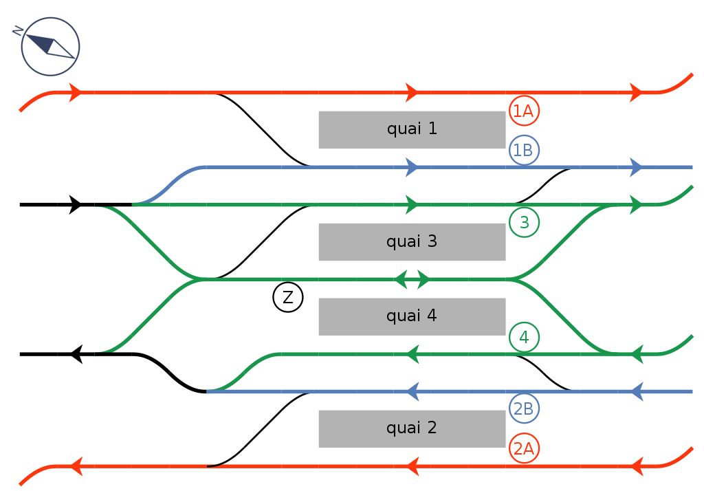
English: Track map of RER Gare de Châtelet - Les Halles in Paris, France. North-West ↔ South-East. Français : Plan des voies du RER à la gare de Châtelet - Les Halles à Paris, France. Nord-Ouest ↔ Sud-Est. |
| Date | |
| Source | Own work |
| Author | Matsukaze |
Licensing[edit]
| I, the copyright holder of this work, release this work into the public domain. This applies worldwide. In some countries this may not be legally possible; if so: I grant anyone the right to use this work for any purpose, without any conditions, unless such conditions are required by law. |
File history
Click on a date/time to view the file as it appeared at that time.
| Date/Time | Thumbnail | Dimensions | User | Comment | |
|---|---|---|---|---|---|
| current | 16:17, 29 October 2020 | | 565 × 394 (106 KB) | Poudou99 (talk | contribs) | Blank background |
| 15:49, 29 October 2020 |  | 640 × 480 (106 KB) | Poudou99 (talk | contribs) | Nouvelle version: changement logo direction du Nord | |
| 19:43, 27 October 2020 |  | 553 × 389 (68 KB) | Poudou99 (talk | contribs) | Fond blanc | |
| 19:31, 27 October 2020 |  | 546 × 383 (67 KB) | Poudou99 (talk | contribs) | Ajout flèche pour la direction du nord | |
| 23:51, 25 October 2020 |  | 540 × 330 (37 KB) | Poudou99 (talk | contribs) | Ajout des numéros de voies et de quais | |
| 14:22, 3 March 2009 |  | 540 × 330 (12 KB) | Matsukaze (talk | contribs) | {{Information |Description= Track map of RER Gare de Châtelet - Les Halles in Paris, France |Source= Own work |Date= 3 Mar. 2009 |Author= Matsukaze |Permission= See below }} Category:Gare de Châtelet - Les Halles <!--{{ImageUpload|basic}}--> |
You cannot overwrite this file.
File usage on Commons
The following page uses this file:
File usage on other wikis
The following other wikis use this file:
- Usage on de.wikipedia.org
- Usage on fr.wikipedia.org
- Usage on ja.wikipedia.org
- Usage on ko.wikipedia.org
- Usage on pt.wikipedia.org
- Usage on ru.wikipedia.org
- Usage on sv.wikipedia.org
- Usage on uk.wikipedia.org