File:Geikie Plateau Glacier.JPG
Jump to navigation
Jump to search

Size of this preview: 800 × 600 pixels. Other resolutions: 320 × 240 pixels | 640 × 480 pixels | 1,024 × 768 pixels.
Original file (1,024 × 768 pixels, file size: 284 KB, MIME type: image/jpeg)
Captions
Captions
Geikie Plateau glacier
Summary[edit]
| Description |
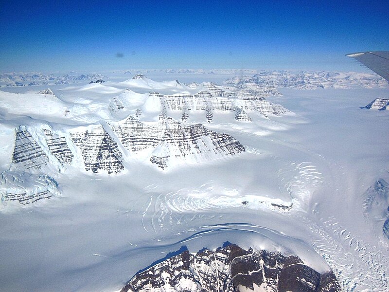
English: Geikie Plateau glacier and mountain peaks in eastern Greenland seen from NASA's P-3B during an IceBridge survey flight on Apr. 11, 2013. The distinctive layering in the Geikie Plateau's mountains come from repeated flooding of basalt lava from the North Atlantic's mid-ocean ridge millions of years ago. |
| Date | |
| Source | http://www.nasa.gov/mission_pages/icebridge/multimedia/spr13/DSCN3043.html |
| Author | NASA / Christy Hansen |
Licensing[edit]
| This file is in the public domain in the United States because it was solely created by NASA. NASA copyright policy states that "NASA material is not protected by copyright unless noted". (See Template:PD-USGov, NASA copyright policy page or JPL Image Use Policy.) | ||
 |
Warnings:
|
File history
Click on a date/time to view the file as it appeared at that time.
| Date/Time | Thumbnail | Dimensions | User | Comment | |
|---|---|---|---|---|---|
| current | 08:35, 27 April 2013 | | 1,024 × 768 (284 KB) | Stas1995 (talk | contribs) | User created page with UploadWizard |
You cannot overwrite this file.
File usage on Commons
The following page uses this file:
- File:Geikie Plateau Glacier (8657045345).jpg (file redirect)
.jpg&redirect=no)
File usage on other wikis
The following other wikis use this file:
- Usage on bh.wikipedia.org
- Usage on blk.wikipedia.org
- Usage on en.wikipedia.org
- Usage on en.wikibooks.org
- Usage on kk.wikipedia.org
- Usage on la.wikipedia.org
- Usage on www.wikidata.org