File:General passcharta öfwer Öster-siöön och Skager-rack - Kungliga Biblioteket - 10346689.tif
Jump to navigation
Jump to search

Size of this JPG preview of this TIF file: 706 × 600 pixels. Other resolutions: 283 × 240 pixels | 565 × 480 pixels | 904 × 768 pixels | 1,205 × 1,024 pixels | 2,410 × 2,048 pixels | 10,674 × 9,070 pixels.
Original file (10,674 × 9,070 pixels, file size: 554 MB, MIME type: image/tiff, 2 pages)
Captions
Captions
Add a one-line explanation of what this file represents
| Warning | The original file is very high-resolution. It might not load properly or could cause your browser to freeze when opened at full size. |
|---|
| Title |
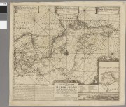
General passcharta öfwer Öster-siöön och Skager-rack – uthwysandes alla courserne på det aldranogaste och accurateste, som det uthi platt och effter een medierat compassens afwÿkningh-görligit warit så effter V:Ammiralens Wölh:ne H. Werner von Rosenfeldts, som egne med flÿt giord observationer, sammanfattat och optecknat |
||||||||||||||||||||||||||
| Description |
Svenska: Hydrografisk karta. - Saknar gradnät och är orienterad efter den för tillfället rådande magnetiska nordriktningen. En liten inlagd kompass visar den rätta nordriktningen. - Städer längs med kusterna utsatta. - Med loxodromer och djupmått. - Med vy över Karlskrona. - Med förklaring till bokstäverna på vyn |
||||||||||||||||||||||||||
| Source |
|
||||||||||||||||||||||||||
| Creator |
Petter Gedda (1661-1697; creator, cartographer) |
||||||||||||||||||||||||||
| Permission (Reusing this file) |
Per the source the digitisations are under
|
||||||||||||||||||||||||||
| Geotemporal data | |||||||||||||||||||||||||||
| Map location |
Svenska: Östersjön, Skagerrak |
||||||||||||||||||||||||||
| Scale | 1:2,700,000 | ||||||||||||||||||||||||||
| Bounding box |
|
||||||||||||||||||||||||||
| Georeferencing | If inappropriate please set warp_status = skip to hide. | ||||||||||||||||||||||||||
| Bibliographic data | |||||||||||||||||||||||||||
| Map sheet | 1 karta | ||||||||||||||||||||||||||
| Language | Swedish | ||||||||||||||||||||||||||
| Publisher |
Unknown, Amsterdam, Netherlands |
||||||||||||||||||||||||||
| Archival data | |||||||||||||||||||||||||||
| Collection |
|
||||||||||||||||||||||||||
| Accession number |
10346689 |
||||||||||||||||||||||||||
| Dimensions | plåt 53 x 59 cm | ||||||||||||||||||||||||||
| Medium | kopparstick | ||||||||||||||||||||||||||
| Notes |
af Petter Gedda a:o 1695
|
||||||||||||||||||||||||||
| Other versions |
 |
||||||||||||||||||||||||||

File history
Click on a date/time to view the file as it appeared at that time.
| Date/Time | Thumbnail | Dimensions | User | Comment | |
|---|---|---|---|---|---|
| current | 15:06, 21 January 2015 |  | 10,674 × 9,070, 2 pages (554 MB) | L PBot (talk | contribs) | {{subst:User:André_Costa_(WMSE)/KB-map |title = General passcharta öfwer Öster-siöön och Skager-rack – uthwysandes alla courserne på det aldranogaste och accurateste, som det uthi platt och effter een medierat compassens afwÿkningh-... |
You cannot overwrite this file.
File usage on Commons
The following 5 pages use this file: