File:Gracchan land distributions.svg
Jump to navigation
Jump to search

Size of this PNG preview of this SVG file: 800 × 500 pixels. Other resolutions: 320 × 200 pixels | 640 × 400 pixels | 1,024 × 640 pixels | 1,280 × 800 pixels | 2,560 × 1,601 pixels | 1,046 × 654 pixels.
Original file (SVG file, nominally 1,046 × 654 pixels, file size: 571 KB)
Captions
Captions
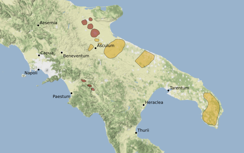
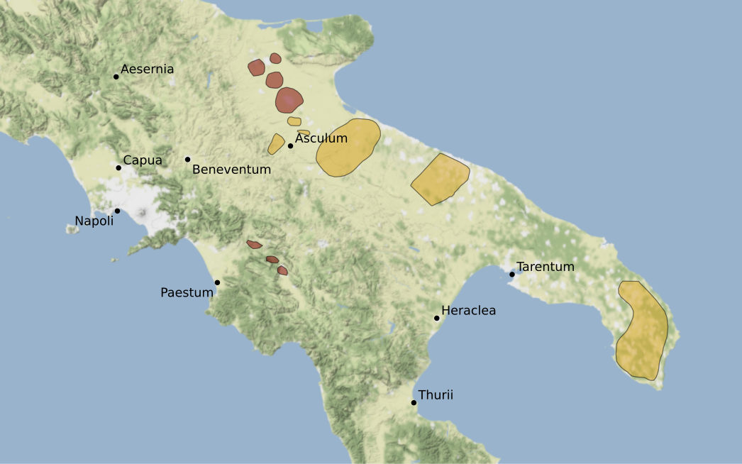
Map of Gracchan land distributions
Summary[edit]
| Description |
English: Map showing areas affected by land distributions, per findings of Gracchan boundary stones (cippi) in consequence of the 133 BC lex Sempronia passed by Tiberius Sempronius Gracchus.
Areas in red are well-documented; areas in gold are highly likely. Background map tiles by Stamen Design. CC-BY 3.0. Based on map data provided by OpenStreeetMap. Location of Gracchan distributions georefrenced from Saskia Roselaar, Public Land in the Roman Republic (OUP, 2010) p. 253. Data plotted on WGS 84 / Pseudo-Mercator (EPSG:3857). |
| Date | |
| Source | Own work |
| Author | Ifly6 |
Licensing[edit]
I, the copyright holder of this work, hereby publish it under the following license:
This file is licensed under the Creative Commons Attribution-Share Alike 4.0 International license.
- You are free:
- to share – to copy, distribute and transmit the work
- to remix – to adapt the work
- Under the following conditions:
- attribution – You must give appropriate credit, provide a link to the license, and indicate if changes were made. You may do so in any reasonable manner, but not in any way that suggests the licensor endorses you or your use.
- share alike – If you remix, transform, or build upon the material, you must distribute your contributions under the same or compatible license as the original.
File history
Click on a date/time to view the file as it appeared at that time.
| Date/Time | Thumbnail | Dimensions | User | Comment | |
|---|---|---|---|---|---|
| current | 01:39, 16 March 2023 | | 1,046 × 654 (571 KB) | Ifly6 (talk | contribs) | removed hardcoded attribution (stamen already attributed in file description) |
| 01:36, 16 March 2023 |  | 1,046 × 654 (669 KB) | Ifly6 (talk | contribs) | outline for shaded areas | |
| 07:10, 15 March 2023 |  | 1,046 × 654 (570 KB) | Ifly6 (talk | contribs) | Uploaded own work with UploadWizard |
You cannot overwrite this file.
File usage on Commons
There are no pages that use this file.
File usage on other wikis
The following other wikis use this file:
- Usage on en.wikipedia.org