File:Grenzstein 71 01 11.jpg

Original file (1,575 × 1,049 pixels, file size: 1.53 MB, MIME type: image/jpeg)
Captions
Captions
Summary[edit]
| Camera location | | View this and other nearby images on: OpenStreetMap |
|---|
| Description |
English:
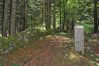
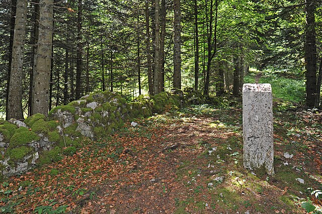
Swiss-French border near La Brévine; Neuchâtel, Switzerland and Doubs, France. Here, near the boundary stone 71, Michel Hollard may have crossed the border. He describes the low wall visible here, which is farther east, where the narrow forest path crosses the border (between boundary stone 70 and 71), not existent. Deutsch: Schweizerisch-französische Grenze bei La Brévine, Neuenburg, Schweiz und Doubs, Frankreich. Hier, nahe dem Grenzstein 71, dürfte Michel Hollard die Grenze gequert haben. Er beschreibt das hier sichtbare Mäuerchen, welches weiter östlich, wo der schmale Waldpfad die Grenze quert (zwischen Grenzstein 70 und 71), nicht vorhanden ist. |
| Date | |
| Source | Own work |
| Author | Хрюша |
Licensing[edit]
- You are free:
- to share – to copy, distribute and transmit the work
- to remix – to adapt the work
- Under the following conditions:
- attribution – You must give appropriate credit, provide a link to the license, and indicate if changes were made. You may do so in any reasonable manner, but not in any way that suggests the licensor endorses you or your use.
- share alike – If you remix, transform, or build upon the material, you must distribute your contributions under the same or compatible license as the original.

|
This media was created by Chriusha/Хрюша.
|
| Attribution (required by the license) | |
| Additional information: | |
|
The mentioned licence on my media is exclusively valid for the version and resolution up to the shown on Wikimedia Commons. Any other version of the shown media or higher resolution optionally available on another website is not included in this licencing and not allowed for free use. | |
|
The values of focal length and aperture in the metadata need to be read with precaution! |
File history
Click on a date/time to view the file as it appeared at that time.
| Date/Time | Thumbnail | Dimensions | User | Comment | |
|---|---|---|---|---|---|
| current | 11:59, 4 December 2011 | | 1,575 × 1,049 (1.53 MB) | Chriusha (talk | contribs) | == {{int:filedesc}} == {{Location|46|59|29.33|N|6|35|32.01|E|type:landmark_region:FR_heading:WSW}} {{Information |Description={{en}}Swiss-French border near La Brévine; Neuchâtel, Switzerland and Doubs, France. Here, near the boundary stone 72, Michel H |
You cannot overwrite this file.
File usage on Commons
The following page uses this file:
- File:Grenzstein 72 01 11.jpg (file redirect)