File:Hampshire UK locator map 2010.svg
Jump to navigation
Jump to search

Size of this PNG preview of this SVG file: 494 × 600 pixels. Other resolutions: 198 × 240 pixels | 395 × 480 pixels | 633 × 768 pixels | 843 × 1,024 pixels | 1,687 × 2,048 pixels | 1,108 × 1,345 pixels.
Original file (SVG file, nominally 1,108 × 1,345 pixels, file size: 302 KB)
Captions
Captions
Add a one-line explanation of what this file represents
Summary
[edit]
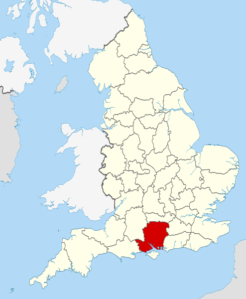
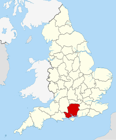
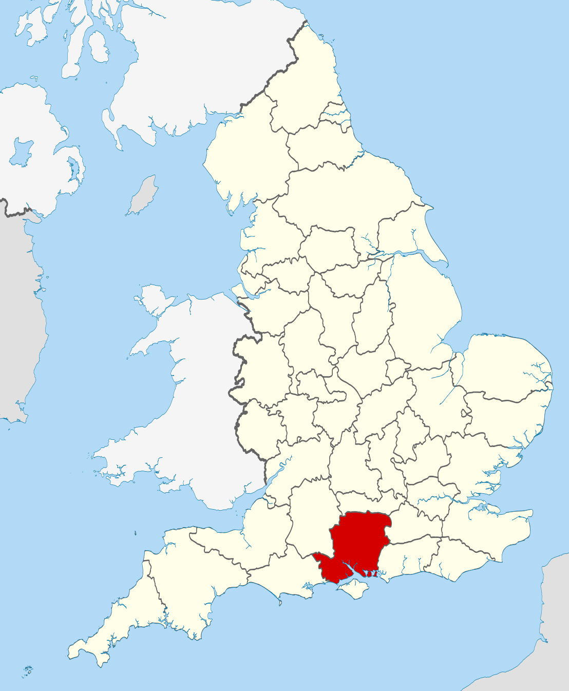
| Description | Location of the ceremonial county of Hampshire within England. |
| Date | |
| Source |
National Geospatial-Intelligence Agency
|
| Author | Nilfanion |
Licensing
[edit]
I, the copyright holder of this work, hereby publish it under the following licenses:
This file is licensed under the Creative Commons Attribution-Share Alike 3.0 Unported license.
- You are free:
- to share – to copy, distribute and transmit the work
- to remix – to adapt the work
- Under the following conditions:
- attribution – You must give appropriate credit, provide a link to the license, and indicate if changes were made. You may do so in any reasonable manner, but not in any way that suggests the licensor endorses you or your use.
- share alike – If you remix, transform, or build upon the material, you must distribute your contributions under the same or compatible license as the original.

|
Permission is granted to copy, distribute and/or modify this document under the terms of the GNU Free Documentation License, Version 1.2 or any later version published by the Free Software Foundation; with no Invariant Sections, no Front-Cover Texts, and no Back-Cover Texts. A copy of the license is included in the section entitled GNU Free Documentation License. |
You may select the license of your choice.

|
This is one of the images forming part of the Valued image set: Locator maps of the Ceremonial counties of England on Wikimedia Commons. The image set has been assessed under the valued image set criteria and is considered the most valued set on Commons within the scope:
Locator maps of the Ceremonial counties of England
You can see its nomination at Commons:Valued image candidates/Locator maps of English ceremonial counties. |
File history
Click on a date/time to view the file as it appeared at that time.
| Date/Time | Thumbnail | Dimensions | User | Comment | |
|---|---|---|---|---|---|
| current | 22:37, 23 November 2010 | | 1,108 × 1,345 (302 KB) | Nilfanion (talk | contribs) | == Summary == {{Information |Description=Location of the ceremonial county of Hampshire within England. |Source=Ordnance Survey [https://www.ordnancesurvey.co.uk/opendatadownload/products.html OpenData]: *County bound |
You cannot overwrite this file.
File usage on Commons
More than 100 pages use this file. The following list shows the first 100 pages that use this file only. A full list is available.
- Valued image set: Locator maps of the Ceremonial counties of England
- Commons:Valued image candidates/Locator maps of English ceremonial counties
- Category:1900 in Hampshire
- Category:1914 in Hampshire
- Category:1915 in Hampshire
- Category:1921 in Hampshire
- Category:1936 in Hampshire
- Category:1938 in Hampshire
- Category:1940 in Hampshire
- Category:1943 in Hampshire
- Category:1944 in Hampshire
- Category:1945 in Hampshire
- Category:1947 in Hampshire
- Category:1950 in Hampshire
- Category:1951 in Hampshire
- Category:1953 in Hampshire
- Category:1955 in Hampshire
- Category:1956 in Hampshire
- Category:1957 in Hampshire
- Category:1958 in Hampshire
- Category:1959 in Hampshire
- Category:1960 in Hampshire
- Category:1961 in Hampshire
- Category:1962 in Hampshire
- Category:1963 in Hampshire
- Category:1964 in Hampshire
- Category:1965 in Hampshire
- Category:1966 in Hampshire
- Category:1967 in Hampshire
- Category:1968 in Hampshire
- Category:1969 in Hampshire
- Category:1970 in Hampshire
- Category:1972 in Hampshire
- Category:1973 in Hampshire
- Category:1974 in Hampshire
- Category:1975 in Hampshire
- Category:1976 in Hampshire
- Category:1978 in Hampshire
- Category:1979 in Hampshire
- Category:1980 in Hampshire
- Category:1981 in Hampshire
- Category:1982 in Hampshire
- Category:1983 in Hampshire
- Category:1984 in Hampshire
- Category:1985 in Hampshire
- Category:1986 in Hampshire
- Category:1987 in Hampshire
- Category:1988 in Hampshire
- Category:1989 in Hampshire
- Category:1990 in Hampshire
- Category:1991 in Hampshire
- Category:1992 in Hampshire
- Category:1993 in Hampshire
- Category:1994 in Hampshire
- Category:1995 in Hampshire
- Category:1996 in Hampshire
- Category:1997 in Hampshire
- Category:1998 in Hampshire
- Category:1999 in Hampshire
- Category:2000 in Hampshire
- Category:2001 in Hampshire
- Category:2002 in Hampshire
- Category:2003 in Hampshire
- Category:2004 in Hampshire
- Category:2005 in Hampshire
- Category:2006 in Hampshire
- Category:2007 in Hampshire
- Category:2008 in Hampshire
- Category:2009 in Hampshire
- Category:2010 in Hampshire
- Category:2011 in Hampshire
- Category:2012 in Hampshire
- Category:2013 in Hampshire
- Category:2014 in Hampshire
- Category:2015 in Hampshire
- Category:2016 in Hampshire
- Category:2017 in Hampshire
- Category:2018 in Hampshire
- Category:Almshouses in Hampshire
- Category:Alumni by school in Hampshire
- Category:Bridges in Hampshire
- Category:Canals in Hampshire
- Category:Cemeteries in Hampshire
- Category:Events in Hampshire
- Category:Geography of Hampshire
- Category:Hampshire
- Category:Hampshire in the 1970s
- Category:Hampshire in the 19th century
- Category:Hampshire in the 20th century
- Category:Hospitals in Hampshire
- Category:Maps of Hampshire
- Category:Populated places in Hampshire
- Category:Rail transport in Hampshire
- Category:Rivers of Hampshire
- Category:Roads in Hampshire
- Category:Sports in Hampshire
- Category:Sports venues in Hampshire
- Category:Towers in Hampshire
- Category:Tunnels in Hampshire
- Category:Views of Hampshire
View more links to this file.
File usage on other wikis
The following other wikis use this file:
- Usage on af.wikipedia.org
- Usage on ar.wikipedia.org
- Usage on ast.wikipedia.org
- Usage on be-tarask.wikipedia.org
- Usage on bg.wikipedia.org
- Usage on br.wiktionary.org
- Usage on ca.wikipedia.org
- Usage on ceb.wikipedia.org
- Usage on cs.wikipedia.org
- Usage on dag.wikipedia.org
- Usage on en.wikipedia.org
- Hampshire
- Lovedean
- Bramdean Common
- Matley Bog
- Spithead
- Mengham
- Tourner Bury
- Hill Head
- Fratton
- Appleshaw
- Hart Plain
- Coombe, Hampshire
- Easton, Hampshire
- Freefolk
- Turgis Green
- Hambledon, Hampshire
- Avon Valley Path
- Clarendon Way
- King's Way
- Pilgrims' Trail
- Bentley, Hampshire
- Hangers Way
- Three Castles Path
- Soberton and Newtown Millennium Walk 2000
- Sutton Scotney
- Castleman Trailway
- Blackwater Valley Path
- Pilot Hill, Hampshire
- Queen Elizabeth Country Park
- North Waltham
- Cliddesden
- Baybridge, Hampshire
- Farther Common
- Lychpit
- Spanish Green
- Template:Hampshire-geo-stub
- Abbots Worthy
- Litchfield, Hampshire
View more global usage of this file.