File:Henry Salt - Ground plan of Carli Cave.jpg
Jump to navigation
Jump to search
Size of this preview: 800 × 494 pixels. Other resolutions: 320 × 198 pixels | 640 × 395 pixels | 1,024 × 633 pixels | 1,280 × 791 pixels | 1,672 × 1,033 pixels.
Original file (1,672 × 1,033 pixels, file size: 1.05 MB, MIME type: image/jpeg)
Captions
Captions
Add a one-line explanation of what this file represents
Summary[edit]
| Ground plan of Carli Cave | ||||||||||||||||||||||||||||||||||||||||||||||||||
|---|---|---|---|---|---|---|---|---|---|---|---|---|---|---|---|---|---|---|---|---|---|---|---|---|---|---|---|---|---|---|---|---|---|---|---|---|---|---|---|---|---|---|---|---|---|---|---|---|---|---|
| Author |
|
|||||||||||||||||||||||||||||||||||||||||||||||||
| Title |
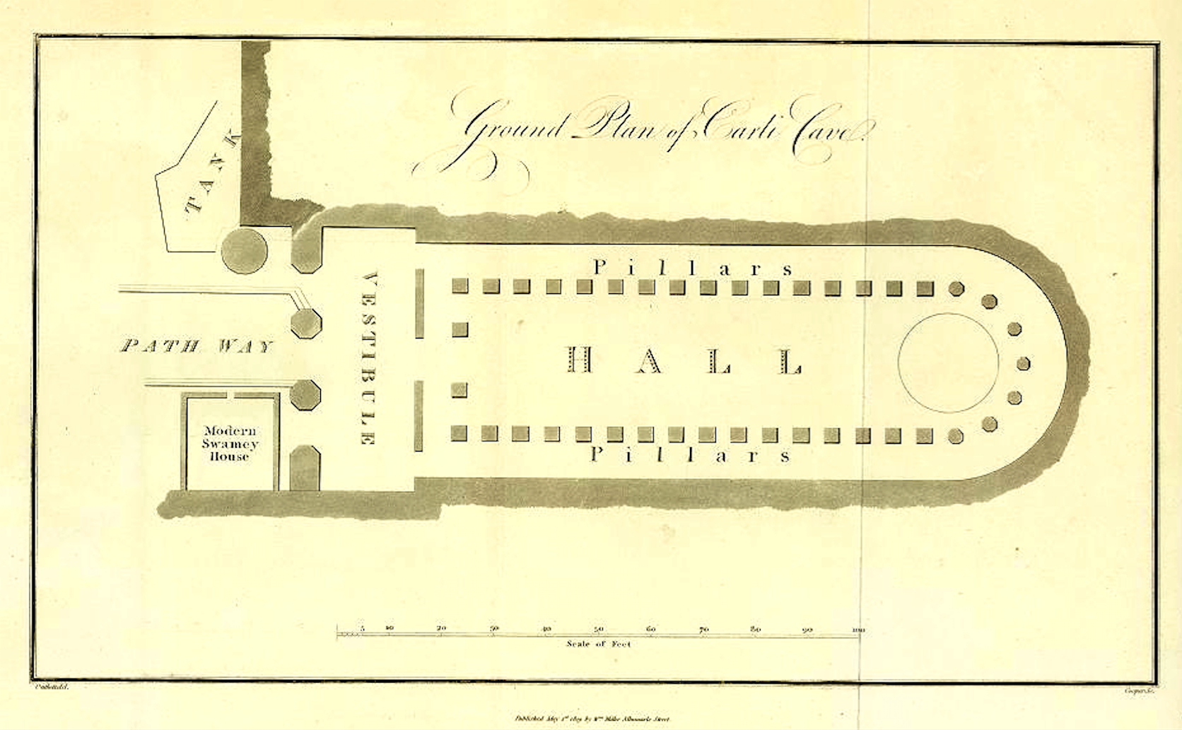
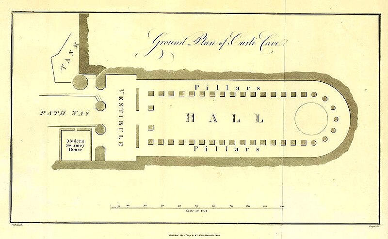
Ground plan of Carli Cave |
|||||||||||||||||||||||||||||||||||||||||||||||||
| Description |
English: Ground Plan of Carli Cave (Karli Cave) engraved by Cooper after a plan by Outhett.
Voyages and Travels to India, Ceylon, the Red Sea, Abyssinia, and Egypt, Vol. 2, plate 9. page 164. Pub 1809. Plan of the Chaitya of Karla. from the book of Valentia, Viscount Geroge; «Voyages and Travels to India, Ceylon, the Red Sea, Abyssinia, and Egypt: In the Years 1802-1806» London 1811, Band 4 (plates),Deutsch: Plan des Chaitya von Karla. aus dem Buch Valentia, Viscount George; «Voyages and Travels to India, Ceylon, the Red Sea, Abyssinia, and Egypt: In the Years 1802-1806» London 1811, Band 4 (plates), |
|||||||||||||||||||||||||||||||||||||||||||||||||
| Depicted place | Karla Caves | |||||||||||||||||||||||||||||||||||||||||||||||||
| Date | May 1809 | |||||||||||||||||||||||||||||||||||||||||||||||||
| Source/Photographer | Valentia, Viscount George; «Voyages and Travels to India, Ceylon, the Red Sea, Abyssinia, and Egypt: In the Years 1802-1806» London 1811, Band 4 (plates) | |||||||||||||||||||||||||||||||||||||||||||||||||
| Other versions |
|
|||||||||||||||||||||||||||||||||||||||||||||||||
.JPG)
.jpg)

Licensing[edit]
|
This is a faithful photographic reproduction of a two-dimensional, public domain work of art. The work of art itself is in the public domain for the following reason:
The official position taken by the Wikimedia Foundation is that "faithful reproductions of two-dimensional public domain works of art are public domain".
This photographic reproduction is therefore also considered to be in the public domain in the United States. In other jurisdictions, re-use of this content may be restricted; see Reuse of PD-Art photographs for details. | ||||
File history
Click on a date/time to view the file as it appeared at that time.
| Date/Time | Thumbnail | Dimensions | User | Comment | |
|---|---|---|---|---|---|
| current | 11:00, 3 June 2023 | | 1,672 × 1,033 (1.05 MB) | Broichmore (talk | contribs) | {{Artwork |author={{Creator:Henry Cooper (engraver)}}{{Creator:Henry Salt|after}} |title= Ground plan of Carli Cave |description= {{en|1= Ground plan of Karla Cave, ''Voyages and Travels to India, Ceylon, the Red Sea, Abyssinia, and Egypt'', Vol. 2, plate 9. page 164. Pub 1809. Plan of the Chaitya of Karla. from the book of Valentia, Viscount Geroge; «Voyages and Travels to India, Ceylon, the Red Sea, Abyssinia, and Egypt: In the Years 1802-1806» London 1811, Band 4 (plates),}} {{de|1=Plan... |
You cannot overwrite this file.
File usage on Commons
The following 4 pages use this file:
%27_(11001343345).jpg)