File:Icebergs B09F, C28B, B15T, and B15Z near the South Orkney Islands (MODIS 2017-10-25).jpg

Original file (2,200 × 1,800 pixels, file size: 856 KB, MIME type: image/jpeg)
Captions
Captions
Summary[edit]
.jpg&action=edit§ion=1)
| Description |
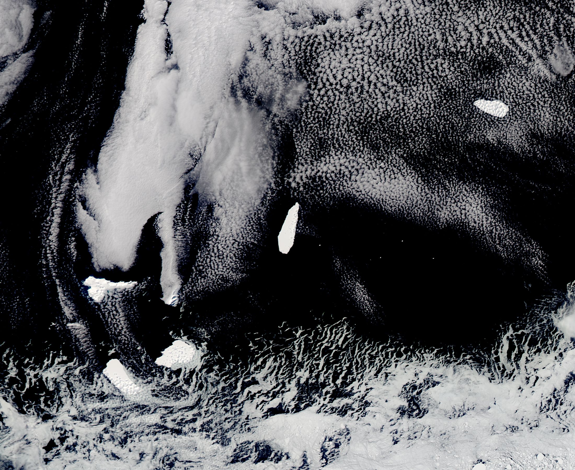
English: In mid-October 2017, 2017, NASA’s Aqua satellite spotted a cluster of icebergs floating in the Southern Ocean near the South Orkney Islands. The Moderate Resolution Imaging Spectroradiometer (MODIS) aboard that satellite acquired a true-color image of the scene on October 20.
The South Orkney Islands are remote islands, sitting about 375 miles (603.5 km) northeast of the tip of the Antarctic Peninsula. The mountainous, generally mist-shrouded islands provide homes for a number of species, such as snow petrels and penguins, but are rarely visited by humans. More common visitors to this frigid area include sea ice and icebergs. The icebergs clustered together in this image bear the names B09F, C28B, B15T, and B15Z. The U.S. National Ice Center (USNIC) monitors all Antarctic icebergs that are larger than 1,900 m (6,233 feet) along one axis. They also are tasked with naming the ‘bergs they track. Iceberg names contain three important pieces of their personal history: the Antarctic quadrant in which they were originally sighted, the order of discovery, and the order of fragmentation. The first letter notes the quadrant in the following formula: A represents 0-90W, the Bellingshausen/Weddell Sea; B represents 90W – 180, the Amundsen/Eastern Ross Sea; C rose from 180-90E, the Western Ross Sea/Wilkesland; and D represents 90E – 0, the Amery Eastern Weddell Sea. The numbers are assigned in the order in which the ‘berg was discovered, and if the iceberg fragments, the fragments are given a final letter in alphabetical order. Following the naming convention, Iceberg B09F was first found in the Amundsen or Eastern Ross Sea, it was the 9th iceberg named from that origin, and was the sixth fragment from Iceberg B09. Likewise, B15T and B15Z were the 20th and 26th fragments from the 15th iceberg discovered in the Amundsen/Eastern Ross Sea. C28B was the second fragment from the 28th iceberg discovered in the Western Ross Sea/Wilkesland. |
||
| Date | Taken on 20 October 2017 | ||
| Source |
Icebergs B09F, C28B, B15T, and B15Z near the South Orkney Islands (direct link)
|
||
| Author | Jeff Schmaltz, MODIS Land Rapid Response Team, NASA GSFC |
| This media is a product of the Aqua mission Credit and attribution belongs to the mission team, if not already specified in the "author" row |
Licensing[edit]
.jpg&action=edit§ion=2)
| This file is in the public domain in the United States because it was solely created by NASA. NASA copyright policy states that "NASA material is not protected by copyright unless noted". (See Template:PD-USGov, NASA copyright policy page or JPL Image Use Policy.) | ||
 |
Warnings:
|
File history
Click on a date/time to view the file as it appeared at that time.
| Date/Time | Thumbnail | Dimensions | User | Comment | |
|---|---|---|---|---|---|
| current | 17:29, 16 February 2024 | | 2,200 × 1,800 (856 KB) | OptimusPrimeBot (talk | contribs) | #Spacemedia - Upload of http://modis.gsfc.nasa.gov/gallery/images/image10252017_250m.jpg via Commons:Spacemedia |
You cannot overwrite this file.
File usage on Commons
There are no pages that use this file.
.jpg&oldid=852761543)