File:Ireland Divided into Its Provinces and Counties &c (btv1b53056672w).jpg
Original file (3,458 × 3,820 pixels, file size: 1.95 MB, MIME type: image/jpeg)
Captions
Captions
Summary[edit]
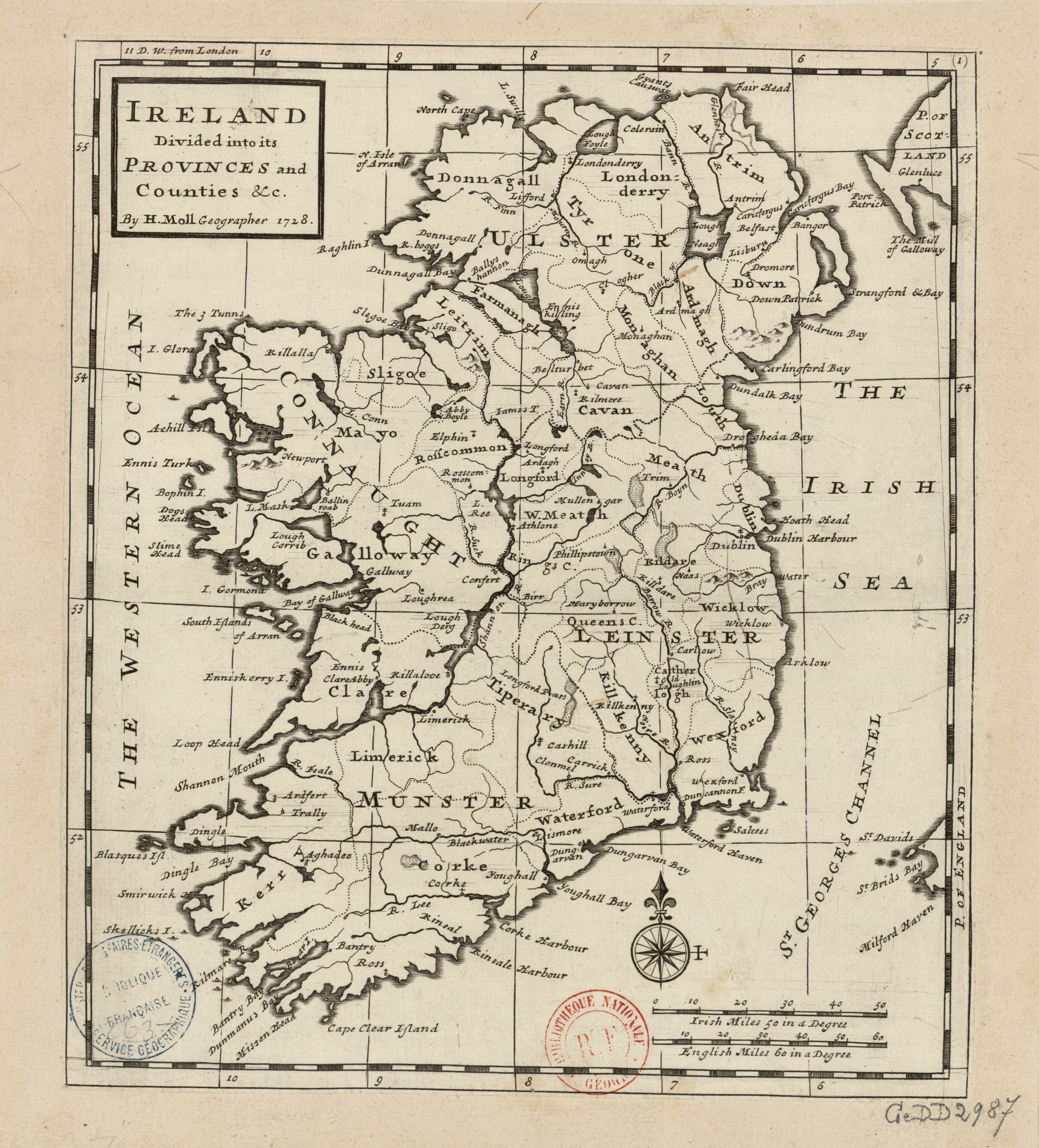
| English: Ireland Divided into Its Provinces and Counties &c.
( |
|||||||||||||||||||||||||||
|---|---|---|---|---|---|---|---|---|---|---|---|---|---|---|---|---|---|---|---|---|---|---|---|---|---|---|---|
| Author |
|
||||||||||||||||||||||||||
| Title |
English: Ireland Divided into Its Provinces and Counties &c. |
||||||||||||||||||||||||||
| Description |
English: Overview map of Ireland c. 1728.
Français : Sujet : Divisions politiques et administratives
Irlande, Royaume d' -- Divisions politiques et administratives Échelle(s) : 50 Irish Miles 50 in a Degree [= 6,6 cm] Appartient à l’ensemble documentaire : AnvilEur Appartient à l’ensemble documentaire : MAEDI008 Appartient à l’ensemble documentaire : MAEDIGen0 Couverture : Irlande Langue : anglais |
||||||||||||||||||||||||||
| Date | 1728 | ||||||||||||||||||||||||||
| Dimensions | height: 30 cm (11.8 in); width: 56 cm (22 in) | ||||||||||||||||||||||||||
| Collection |
|
||||||||||||||||||||||||||
| References |
Français : Notice de recueil : http://catalogue.bnf.fr/ark:/12148/cb40577015h
Appartient à : Collection d'Anville ; 02637 Notice du catalogue : http://catalogue.bnf.fr/ark:/12148/cb41202030c Extrait de A Set of Twenty New and Correct Maps of Ireland, with the Great Roads and Principal Cross-Roads, shewing the computed Miles from Town to Town ; very Useful for all Gentlemen that travel to any Part of that Kingdom, 1728. |
||||||||||||||||||||||||||
| Source/Photographer |
From a copy of A Set of Twenty New and Correct Maps of Ireland, with the Great Roads and Principal Cross-Roads, Shewing the Computed Miles from Town to Town, Very Useful for All Gentlemen that Travel to Any Part of That Kingdom, held in the D'Anville Collection of the French National Library. Français : Bibliothèque nationale de France, département Cartes et plans, GE DD-2987 (2637)
Bibliothèque nationale de France |
||||||||||||||||||||||||||
| Permission (Reusing this file) |
|
||||||||||||||||||||||||||
| Other versions |
|
||||||||||||||||||||||||||


.jpg&action=edit§ion=1)
| Annotations | This image is annotated: View the annotations at Commons |
.jpg)
File history
Click on a date/time to view the file as it appeared at that time.
| Date/Time | Thumbnail | Dimensions | User | Comment | |
|---|---|---|---|---|---|
| current | 10:56, 20 May 2023 | | 3,458 × 3,820 (1.95 MB) | LlywelynII (talk | contribs) | File:Ireland Divided into its Provinces and Counties &c. - By H. Moll Geographer - btv1b53056672w.jpg cropped using CropTool. |
You cannot overwrite this file.
File usage on Commons
The following 19 pages use this file:
- File:Ireland Divided into Its Provinces and Counties &c (btv1b53056672w).jpg
- File:Ireland Divided into its Provinces and Counties &c. - By H. Moll Geographer - btv1b53056672w.jpg
- File:King's County, Queen's County and Kildare County - By H. Moll Geographer - btv1b53056779d.jpg
- File:The Counties of Antrim, Ardmagh and Down - By H. Moll Geographer - btv1b530565786.jpg
- File:The Counties of Clare and Limerick - By H. Moll Geographer - btv1b53056962m.jpg
- File:The Counties of Corke & Kerry Divided into theirs Barronies - By H. Moll Geographer - btv1b530566149.jpg
- File:The Counties of Donnagal, Tyrone and Londonderry - By H. Moll Geographer - btv1b53057014c.jpg
- File:The Counties of Dublin and Louth - By H. Moll Geographer - btv1b53056651m.jpg
- File:The Counties of Farmanagh, Leitrim, Cavan, and Monaghan - By H. Moll Geographer - btv1b530563842.jpg
- File:The Counties of Gallway - By H. Moll Geographer - btv1b53056434c.jpg
- File:The Counties of Longford, Meath and Eastmeath - By H. Moll Geographer - btv1b530565623.jpg
- File:The Counties of Sligoe and Mayo - By H. Moll Geographer - btv1b530561688.jpg
- File:The Counties of Wicklow, Catherlogh, and Wexford - By H. Moll Geographer - btv1b530566255.jpg
- File:The County of Rosscommon - By H. Moll Geographer - btv1b53056423h.jpg
- File:The County or Palatinate of Tipperary with The Counties of Waterford and Killkenny - By H. Moll Geographer - btv1b53056613v.jpg
- File:The Province of Connaught Divided into its Counties and the Counties into their severall Barronies and c. - By H. Moll Geographer - btv1b53056320s.jpg
- File:The Province of Leinster Divided into its Counties wherein are distinguished all the Borroughs &c. - By H. Moll Geographer - btv1b530569130.jpg
- File:The Province of Munster Divided into its Counties wherein are distinguished all the Borroughs &c. - By H. Moll Geographer - btv1b53056246x.jpg
- File:The Province of Ulster Divided into its Counties and ye Counties into their severall Barronies &c. with the Great Roads - By H. Moll Geographer - btv1b53056868x.jpg
.jpg)
.jpg&oldid=833444590)