File:Isle of Man topographic map-es.svg
Jump to navigation
Jump to search

Size of this PNG preview of this SVG file: 654 × 600 pixels. Other resolutions: 262 × 240 pixels | 524 × 480 pixels | 838 × 768 pixels | 1,117 × 1,024 pixels | 2,234 × 2,048 pixels | 1,200 × 1,100 pixels.
Original file (SVG file, nominally 1,200 × 1,100 pixels, file size: 643 KB)
Captions
Captions
Add a one-line explanation of what this file represents
Summary
[edit]| Description |
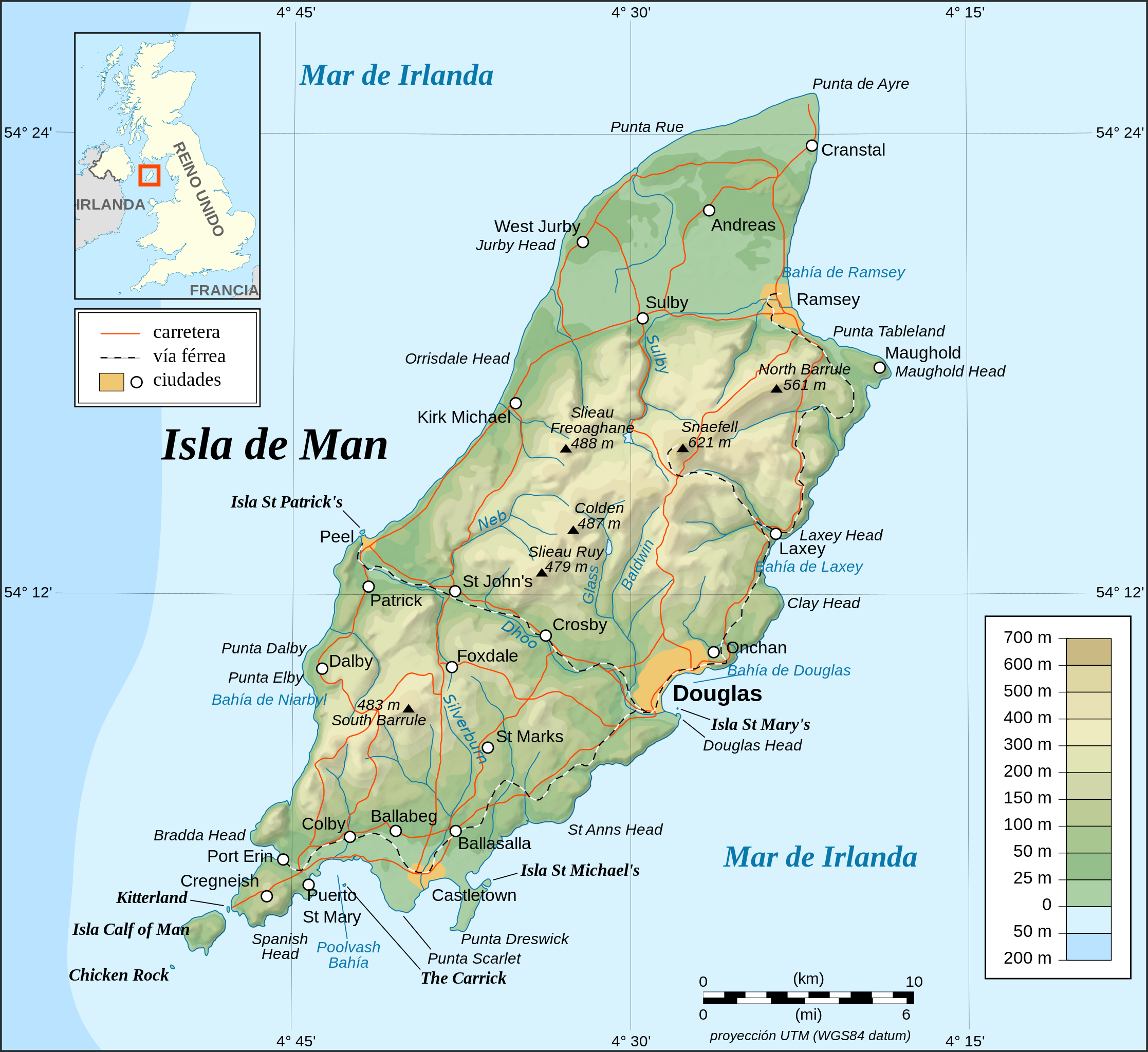
English: Topographic map in Spanish of the Isle of Man.
Note : The shaded relief is a raster image embedded in the SVG. Español: Mapa topográfico en español de la Isla de Man.
Nota : El relieve sombreado es una imagen bitmap integrada en el SVG. Français : Carte topographique en espagnol de l'Île de Man.
Note : Le relief ombré est une image bitmap embarquée dans le fichier SVG. Português: Mapa topográfico (em Espanhol) da Ilha de Man.
Русский: Топографическая карта Острова Мэн на испáнский языке |
| Date | May 2007 (Translated May 2010) |
| Source |
Own work ;
|
| Author | Eric Gaba (Sting), translated by Koszmonaut |
| Other versions |
[]
|


|
This SVG file contains embedded text that can be translated into your language, using any capable SVG editor, text editor or the SVG Translate tool. For more information see: About translating SVG files. |
Licensing
[edit]
I, the copyright holder of this work, hereby publish it under the following licenses:

|
Permission is granted to copy, distribute and/or modify this document under the terms of the GNU Free Documentation License, Version 1.2 or any later version published by the Free Software Foundation; with no Invariant Sections, no Front-Cover Texts, and no Back-Cover Texts. A copy of the license is included in the section entitled GNU Free Documentation License. |
This file is licensed under the Creative Commons Attribution-Share Alike 4.0 International, 3.0 Unported, 2.5 Generic, 2.0 Generic and 1.0 Generic license.
- You are free:
- to share – to copy, distribute and transmit the work
- to remix – to adapt the work
- Under the following conditions:
- attribution – You must give appropriate credit, provide a link to the license, and indicate if changes were made. You may do so in any reasonable manner, but not in any way that suggests the licensor endorses you or your use.
- share alike – If you remix, transform, or build upon the material, you must distribute your contributions under the same or compatible license as the original.
You may select the license of your choice.
File history
Click on a date/time to view the file as it appeared at that time.
| Date/Time | Thumbnail | Dimensions | User | Comment | |
|---|---|---|---|---|---|
| current | 00:28, 27 May 2010 | | 1,200 × 1,100 (643 KB) | Koszmonaut (talk | contribs) | {{Information |Description=Topographic man in Spanish of the Isle of Man |Source=http://commons.wikimedia.org/wiki/File:Isle_of_Man_topographic_map-en.svg |Date=May 2007 (Translated May 2010) |Author=Eric Gaba (User:Sting), translated by ([[User:Koszm |
You cannot overwrite this file.
File usage on Commons
The following 15 pages use this file:
- File:Isle of Man map-en.svg
- File:Isle of Man map-fr.svg
- File:Isle of Man topographic map-de.svg
- File:Isle of Man topographic map-el.svg
- File:Isle of Man topographic map-en.svg
- File:Isle of Man topographic map-es.svg
- File:Isle of Man topographic map-fr.svg
- File:Isle of Man topographic map-hu.svg
- File:Isle of Man topographic map-it.svg
- File:Isle of Man topographic map-mk.svg
- File:Isle of Man topographic map-nb.svg
- File:Isle of Man topographic map-ru.svg
- File:Isle of man-es.svg (file redirect)
- File:Isle of man topographic map-es.svg (file redirect)
- Template:Other versions/Isle of Man topographic map
File usage on other wikis
The following other wikis use this file:
- Usage on ast.wikipedia.org
- Usage on es.wikipedia.org
- Usage on gl.wikipedia.org
- Usage on it.wikipedia.org