File:Italy 1000 AD-he.svg
Jump to navigation
Jump to search

Size of this PNG preview of this SVG file: 418 × 600 pixels. Other resolutions: 167 × 240 pixels | 334 × 480 pixels | 535 × 768 pixels | 713 × 1,024 pixels | 1,427 × 2,048 pixels | 565 × 811 pixels.
Original file (SVG file, nominally 565 × 811 pixels, file size: 481 KB)
Captions
Captions
Add a one-line explanation of what this file represents
| Description |
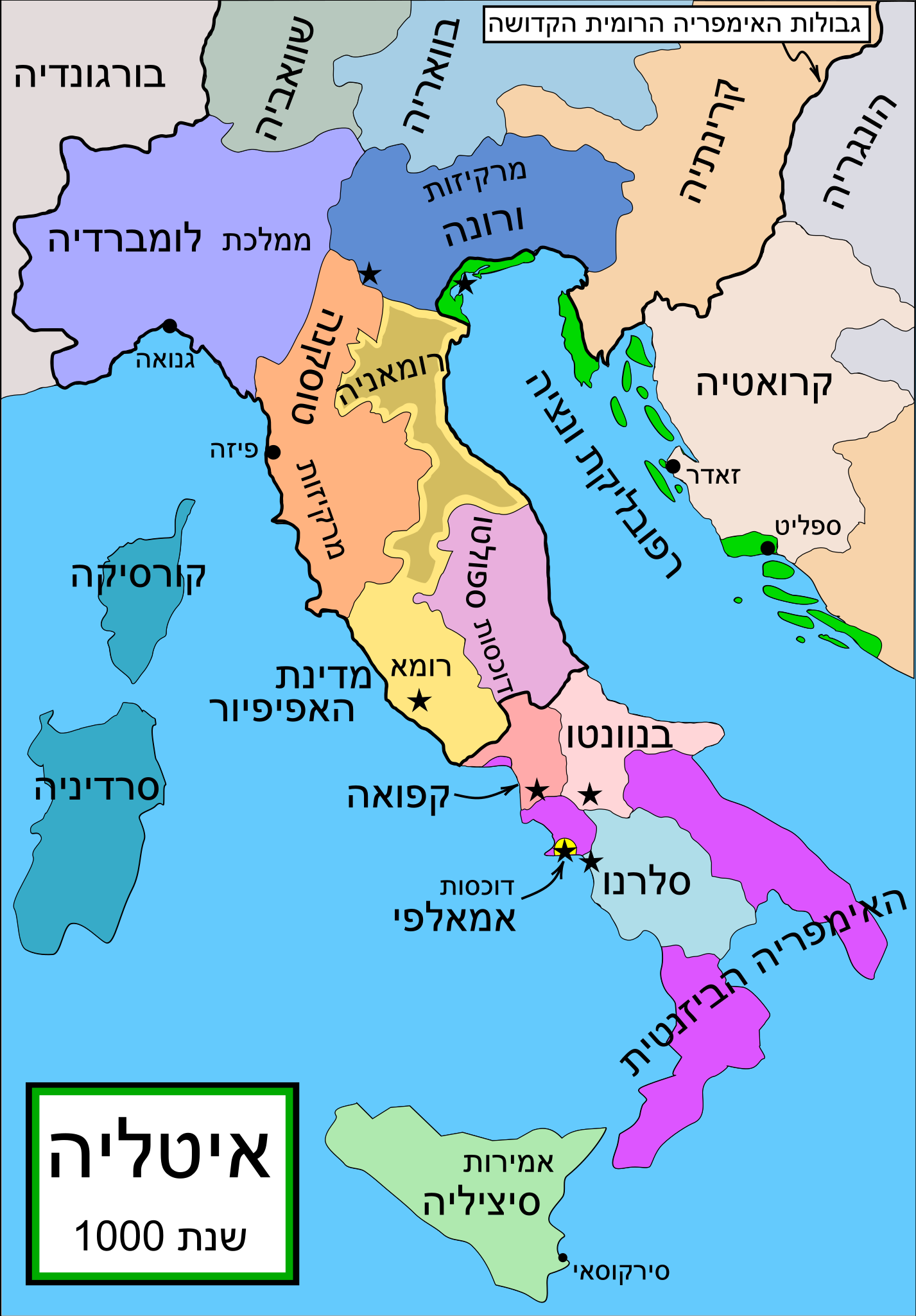
English: Political map of Italy in 1000 AD (CE). Created by MapMaster. |
| Date | (UTC) |
| Source | |
| Author |
|
| Other versions |
Part of a series of maps on the history of Italy:
[]
SVG:
PNG:
|


|
This SVG file contains embedded text that can be translated into your language, using any capable SVG editor, text editor or the SVG Translate tool. For more information see: About translating SVG files. |
References[edit]
- Bjorklund, Oddvar; Holmboe, Haakon; Rohr, Anders (1970) Historical Atlas of the World, Barnes & Noble, NY, SBN: 389-00253-4.
- This map from Allyn & Bacon, Longman, textbook publishers. * This map of the w:en:Holy Roman Empire *A map from Attilios
- This map of 1050 AD Italy, from the 1923 The Historical Atlas by William R. Shepherd
- This map of 1000 AD Italy from Fordham University, adapted from Muir's Historical Atlas, (1911).
In addition, a number of other sources were consulted in an effort to determine the following matters:
- The extent of Venetian control over the cities of Dalmatia such as Zara and Spalato. Although the Venetians had been pushed off the mainland earlier, in the period around the year 1000, the Venetians made an effort to recover these cities.
- The extent of Saracen control over Corsica and Sardinia. Information is sparse. The apparent situation is that the Muslims had several bases on the coasts of these islands, but did not control the countryside (such as they did in Sicily).
- Whether or not the principalities of Capua and Benevento were separate states in the year 1000. Based on lists of their rulers (various Pandulfs and Landulfs), the answer seems to be "yes".
- Who controlled the Balkans on the southeastern border of the Kingdom of Croatia. Candidates include Bulgaria, the Byzantine Empire, Croatia, and Serbia. As noted, there is significant disagreement among sources on these questions.
This map was commissioned by Attilios, and there is also a discussion to be found on MapMaster's English talk page.
| This is a retouched picture, which means that it has been digitally altered from its original version. Modifications: Translated to Hebrew. The original can be viewed here: Italy 1000 AD.svg:
|
I, the copyright holder of this work, hereby publish it under the following license:

|
Permission is granted to copy, distribute and/or modify this document under the terms of the GNU Free Documentation License, Version 1.2 or any later version published by the Free Software Foundation; with no Invariant Sections, no Front-Cover Texts, and no Back-Cover Texts. A copy of the license is included in the section entitled GNU Free Documentation License. |
| This file is licensed under the Creative Commons Attribution-Share Alike 3.0 Unported license. | ||
| ||
| This licensing tag was added to this file as part of the GFDL licensing update. |
Original upload log[edit]
This image is a derivative work of the following images:
- File:Italy_1000_AD.svg licensed with GFDL
- 2007-04-17T19:50:51Z MapMaster 565x811 (881823 Bytes) Some further changes
- 2007-02-19T05:10:41Z MapMaster 565x811 (843586 Bytes) changes to ensure consistency with my other Italy maps
- 2006-11-25T05:39:26Z MapMaster 565x811 (842813 Bytes) Improved map.
- 2006-11-18T14:44:51Z MapMaster 565x811 (847000 Bytes) Improved (I hope) version based on recommendations from Attilios.
- 2006-11-17T21:50:24Z MapMaster 565x811 (786867 Bytes) Political map of Italy in 1000 AD (CE).
Uploaded with derivativeFX
File history
Click on a date/time to view the file as it appeared at that time.
| Date/Time | Thumbnail | Dimensions | User | Comment | |
|---|---|---|---|---|---|
| current | 23:05, 4 May 2009 | | 565 × 811 (481 KB) | Odedee (talk | contribs) | {{Information |Description='''en:''' Political map of Italy in 1000 AD (CE). Created by MapMaster. Part of a series of maps on the history of Italy: <gallery> Image:Italy and Illyria 1084 v2.svg|1084 AD Image:Italy 1494 v2.png|1494 AD Image:Italy 1796.p |
You cannot overwrite this file.
File usage on Commons
The following 33 pages use this file:
- File:Italia 1000 AD-Ido.svg
- File:Italy 1000 AD-ar.svg
- File:Italy 1000 AD-cs.svg
- File:Italy 1000 AD-de.svg
- File:Italy 1000 AD-el.png
- File:Italy 1000 AD-es.svg
- File:Italy 1000 AD-fr.svg
- File:Italy 1000 AD-he.svg
- File:Italy 1000 AD-hu.svg
- File:Italy 1000 AD-it.svg
- File:Italy 1000 AD-pl.png
- File:Italy 1000 AD-ru.svg
- File:Italy 1000 AD-zh.png
- File:Italy 1000 AD-zh.svg
- File:Italy 1000 AD.svg
- File:Italy 1000 AD - HE.svg (file redirect)
- File:Italy 1000 AD.svg
- File:Italy 1000 AD-it.svg
- File:Italy 1000 AD-de.svg
- File:Italy 1000 AD-es.svg
- File:Italy 1000 AD-pl.png
- File:Italy 1000 AD-fr.svg
- File:Italy 1000 AD-cs.svg
- File:Italy 1000 AD-hu.svg
- Template:Other versions/Italy 1000 AD
- File:Italy 1000 AD-he.svg
- File:Italy 1000 AD-ru.svg
- File:Italy 1000 AD-ar.svg
- File:Italy 1000 AD-el.png
- File:Italy 1000 AD-zh.svg
- File:Italy 1000 AD-zh.png
- File:Italia 1000 AD-Ido.svg
- Template:Other versions/Italy 1000 AD
File usage on other wikis
The following other wikis use this file:
- Usage on he.wikipedia.org
Categories:
- Maps of the Kingdom of Italy (Holy Roman Empire)
- Maps of the Republic of Venice
- Maps of 10th-century Italy
- Maps of the history of Sardinia
- Principate of Salerno
- Emirate of Sicily
- Maps of the Kingdom of Sicily
- Maps showing 10th-century history
- SVG maps of the history of Italy
- Hebrew-language SVG maps showing history