File:Italy and Illyria 1084 AD-it.svg
Jump to navigation
Jump to search

Size of this PNG preview of this SVG file: 480 × 600 pixels. Other resolutions: 192 × 240 pixels | 384 × 480 pixels | 614 × 768 pixels | 819 × 1,024 pixels | 1,638 × 2,048 pixels | 588 × 735 pixels.
Original file (SVG file, nominally 588 × 735 pixels, file size: 944 KB)
Captions
Captions
Add a one-line explanation of what this file represents
| Description |
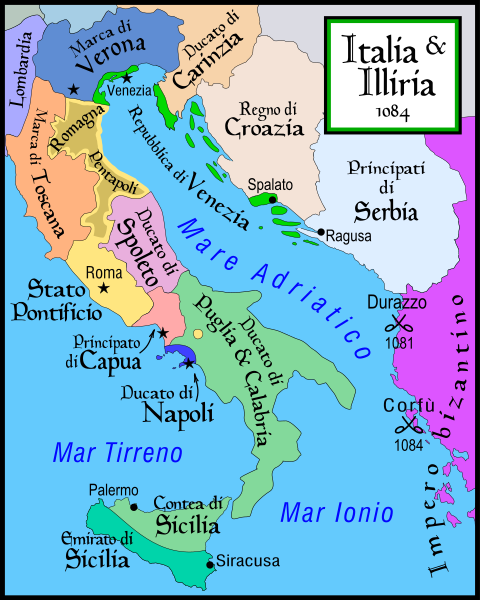
Italiano: Cartina dell'Italia e delle coste illiriche nel 1084. Parte di una serie di cartine dedicata alla storia italiana:
English: Map of Italy and the Illyrian coast in the year 1084. Part of a series of maps on the history of Italy:
Français : Carte d'Italie et de la cote illyrienne en 1084. partie d'une série dédiée à l'histoire de l'Italie:
|
| Date | (UTC) |
| Source |
|
| Author | |
| Other versions |
[]
|


| This is a retouched picture, which means that it has been digitally altered from its original version. Modifications: translation in italian. The original can be viewed here: Italy and Illyria 1084 v2.svg:
|
I, the copyright holder of this work, hereby publish it under the following license:
This file is licensed under the Creative Commons Attribution-Share Alike 2.5 Generic license.
- You are free:
- to share – to copy, distribute and transmit the work
- to remix – to adapt the work
- Under the following conditions:
- attribution – You must give appropriate credit, provide a link to the license, and indicate if changes were made. You may do so in any reasonable manner, but not in any way that suggests the licensor endorses you or your use.
- share alike – If you remix, transform, or build upon the material, you must distribute your contributions under the same or compatible license as the original.
Original upload log[edit]
This image is a derivative work of the following images:
- File:Italy_and_Illyria_1084_v2.svg licensed with Cc-by-sa-2.5
- 2007-07-29T12:20:43Z Lokal Profil 588x735 (659776 Bytes) Cleaned up code (specifically loads of empty groups)
- 2007-04-15T05:43:43Z MapMaster 588x735 (711771 Bytes) Minor changes
- 2007-02-13T03:56:13Z MapMaster 588x735 (710980 Bytes) Map of Italy and the Illyrian coast in the year 1084
Uploaded with derivativeFX
File history
Click on a date/time to view the file as it appeared at that time.
| Date/Time | Thumbnail | Dimensions | User | Comment | |
|---|---|---|---|---|---|
| current | 18:52, 23 May 2009 | | 588 × 735 (944 KB) | Franco aq (talk | contribs) | fix "Venezia" |
| 11:11, 16 May 2009 |  | 588 × 735 (938 KB) | Franco aq (talk | contribs) | Inversione colori della Sicilia | |
| 09:44, 16 May 2009 |  | 588 × 735 (938 KB) | Otourly (talk | contribs) | fix error | |
| 09:36, 16 May 2009 |  | 588 × 735 (939 KB) | Franco aq (talk | contribs) | Nuovo tentativo di eliminare i problemi di visualizzazione. | |
| 09:27, 16 May 2009 |  | 588 × 735 (868 KB) | Franco aq (talk | contribs) | Tentativo di eliminazione dei difetti di visualizzazione | |
| 09:09, 16 May 2009 |  | 588 × 735 (458 KB) | Franco aq (talk | contribs) | {{Information |Description=Map of Italy and the Illyrian coast in the year 1084. Part of a series of maps on the history of Italy: <gallery> Image:Italy 1000 AD.svg|1000 AD Image:Italy 1494 v2.png|1494 AD Image:Italy 1796.png|1796 AD Image:Italy c 1810.p |
You cannot overwrite this file.
File usage on Commons
The following 23 pages use this file:
- File:Italia ed Illiria nel 1084.svg (file redirect)
- File:Italy and Illyria 1084 AD.svg
- File:Italy and Illyria 1084 AD-sv.png
- File:Italy and Illyria 1084 AD-cs.svg
- File:Italy and Illyria 1084 AD-it.svg
- File:Italy and Illyria 1084 AD-ru.svg
- File:Italy and Illyria 1084 AD-fr.svg
- File:Italy and Illyria 1084 AD-hu.svg
- Template:Other versions/Italy and Illyria 1084 AD
- File:Italy and Illyria 1084 AD-zh.svg
- File:Italy and Illyria 1084 AD-zh.png
- File:Italy and Illyria 1084 AD-vi.svg
- File:Italy and Illyria 1084 AD-cs.svg
- File:Italy and Illyria 1084 AD-fr.svg
- File:Italy and Illyria 1084 AD-hu.svg
- File:Italy and Illyria 1084 AD-it.svg
- File:Italy and Illyria 1084 AD-ru.svg
- File:Italy and Illyria 1084 AD-sv.png
- File:Italy and Illyria 1084 AD-vi.svg
- File:Italy and Illyria 1084 AD-zh.png
- File:Italy and Illyria 1084 AD-zh.svg
- File:Italy and Illyria 1084 AD.svg
- Template:Other versions/Italy and Illyria 1084 AD
File usage on other wikis
The following other wikis use this file:
- Usage on br.wikipedia.org
- Usage on ca.wikipedia.org
- Usage on de.wikipedia.org
- Usage on es.wikipedia.org
- Usage on fr.wikipedia.org
- Usage on hr.wikipedia.org
- Usage on it.wikipedia.org
- Usage on scn.wikipedia.org
- Usage on tr.wikipedia.org
- Usage on vec.wikipedia.org