File:KSPI FAA Airport Diagram.svg
Jump to navigation
Jump to search

Size of this PNG preview of this SVG file: 390 × 599 pixels. Other resolutions: 156 × 240 pixels | 313 × 480 pixels | 500 × 768 pixels | 667 × 1,024 pixels | 1,334 × 2,048 pixels | 484 × 743 pixels.
Original file (SVG file, nominally 484 × 743 pixels, file size: 736 KB)
Captions
Captions
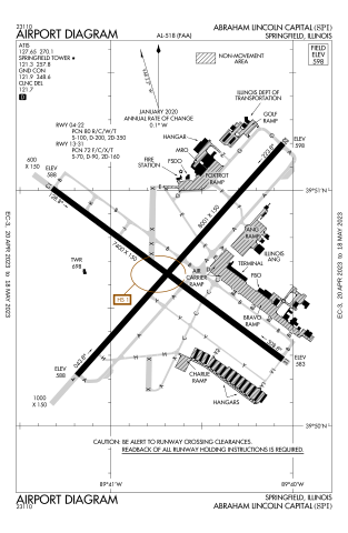
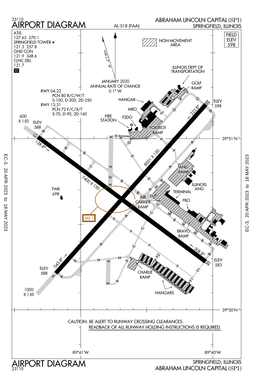
Airport diagram for Abraham Lincoln Capital Airport
Summary[edit]
| Description |
English: Airport diagram for Abraham Lincoln Capital Airport in Springfield Il,
Deutsch: Flughafendiagramm für den Abraham Lincoln Capital Airport in Springfield Il, |
| Date | |
| Source | https://aeronav.faa.gov/d-tpp/2304/00518AD.PDF |
| Author | Produced by the National Aeronautical Charting Office (NACO), a department of the Federal Aviation Administration (FAA). |
| Permission (Reusing this file) |
Public Domain |
| Camera location | | View this and other nearby images on: OpenStreetMap |
|---|
Licensing[edit]
This image or file is a work of a Federal Aviation Administration employee, taken or made as part of that person's official duties. As a work of the U.S. federal government, the image is in the public domain in the United States.
|
 |
File history
Click on a date/time to view the file as it appeared at that time.
| Date/Time | Thumbnail | Dimensions | User | Comment | |
|---|---|---|---|---|---|
| current | 21:47, 22 April 2023 | | 484 × 743 (736 KB) | KDTW Flyer (talk | contribs) | Uploaded own work with UploadWizard |
You cannot overwrite this file.
File usage on Commons
The following 3 pages use this file:
File usage on other wikis
The following other wikis use this file:
- Usage on en.wikipedia.org
- Usage on www.wikidata.org