File:Kapellen - Karl-Ludwig-Haus (2).JPG
Jump to navigation
Jump to search

Size of this preview: 800 × 533 pixels. Other resolutions: 320 × 213 pixels | 640 × 427 pixels | 1,024 × 682 pixels | 1,280 × 853 pixels | 1,772 × 1,181 pixels.
Original file (1,772 × 1,181 pixels, file size: 1.86 MB, MIME type: image/jpeg)
Captions
Captions
Add a one-line explanation of what this file represents
Summary[edit]
| Description |
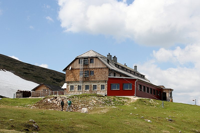
Deutsch: Südostansicht des Karl-Ludwig-Hauses auf der Rax in der steiermärkischen Gemeinde Neuberg an der Mürz (vormals Gemeinde Kapellen).
Das Schutzhaus auf 1804 m Höhe, benannt nach Erzherzog Carl Ludwig von Habsburg-Lothringen, wurde ab 1876 von dem Österreichischen Touristenklub (ÖTK) errichtet und am 17. September 1877 feierlich eröffnet. Die erste Erweiterung bzw. der erste Zubau erfolgt 1903; weitere Zu- und Umbauten fanden in den Jahren 1908–1910 und 1928 statt. Die Materialseilbahn wurde 1930 errichtet und 1982 erneuertː [1]. In den Jahren 2010 bis 2011 erfolgte eine Generalsanierung hin zu einer Art Berghotel mit zuvor nie gekanntem Komfortː [2]. Es verfügt über 36 Betten in 14 Zimmern, 21 Betten in 2 Matratzenlager, 4 großzügige Gasträume, schöne große Sonnenterrasse, Waschräume mit Duschen und getrennten WCː [3]. In der Wintersaison 2022/23 und im Sommer 2023 war das Haus geschlossen, weil kein Pächter gefunden wurdeː [4]. English: Southeast view of the Karl-Ludwig-Haus on the Rax in Austria. |
| Date | |
| Source | Own work |
| Author | C.Stadler/Bwag |
| Permission (Reusing this file) |
Deutsch: Hallo, du darfst mein Foto kostenlos nutzen, aber nenne mich bitte als Fotograf, beispielsweise „Foto: C.Stadler/Bwag“ oder © C.Stadler/Bwag; CC-BY-SA-4.0. Auf mehr Angaben bestehe ich nicht - im Gegensatz zu manch anderen, die die Vorgaben der unten angeführten Lizenzierung auf Punkt und Beistrich einfordern. English: Feel free to use my photos, but please mention me as the author like © C.Stadler/Bwag or © C.Stadler/Bwag; CC-BY-SA-4.0 (that's good enough) and if you want send me a message: bwag@gmx.net. |
| Other versions |
|

.JPG)
.JPG&action=edit§ion=1)
| Object location | | View this and other nearby images on: OpenStreetMap |
|---|
.JPG¶ms=047.688590_N_0015.704140_E_globe:Earth_class:object_type:object__&language=en)
Licensing[edit]
.JPG&action=edit§ion=2)
I, the copyright holder of this work, hereby publish it under the following license:
This file is licensed under the Creative Commons Attribution-Share Alike 3.0 Unported license.
- You are free:
- to share – to copy, distribute and transmit the work
- to remix – to adapt the work
- Under the following conditions:
- attribution – You must give appropriate credit, provide a link to the license, and indicate if changes were made. You may do so in any reasonable manner, but not in any way that suggests the licensor endorses you or your use.
- share alike – If you remix, transform, or build upon the material, you must distribute your contributions under the same or compatible license as the original.
File history
Click on a date/time to view the file as it appeared at that time.
| Date/Time | Thumbnail | Dimensions | User | Comment | |
|---|---|---|---|---|---|
| current | 12:25, 29 May 2012 | | 1,772 × 1,181 (1.86 MB) | Bwag (talk | contribs) | {{Information |Description ={{en|1=Karl-Ludwig-Haus}} |Source =Bwag |Author =Bwag |Date = |Permission = |other_versions = }} {{self|cc-by-sa-3.0}} |
| 18:31, 27 May 2012 |  | 1,772 × 1,181 (1.95 MB) | Bwag (talk | contribs) | {{Information |Description= {{de|1= Südostansicht des Karl-Ludwig-Hauses auf der Rax.}} |Source= {{own}} |Date= 2012-05-26 |Author= Bwag |Permission= {{User:Bwag/Credits}} |other versions= }} == L... |
You cannot overwrite this file.
File usage on Commons
The following 4 pages use this file:
.JPG)
File usage on other wikis
The following other wikis use this file:
- Usage on de.wikipedia.org
- Usage on www.wikidata.org
.JPG&oldid=807030797)