File:Karte-S21-Berlin.png
Jump to navigation
Jump to search
Size of this preview: 469 × 599 pixels. Other resolutions: 188 × 240 pixels | 376 × 480 pixels | 601 × 768 pixels | 1,173 × 1,498 pixels.
Original file (1,173 × 1,498 pixels, file size: 1.39 MB, MIME type: image/png)
Captions
Captions
Add a one-line explanation of what this file represents
| Description |
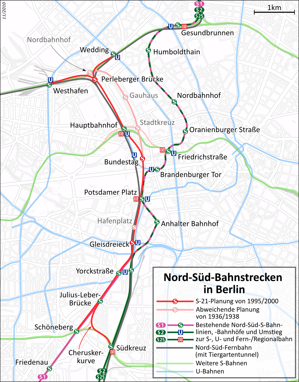
Deutsch: Lage der geplanten zweiten Nord-Süd-S-Bahn (Projektname: S21) im heutigen Verkehrsnetz von Berlin
English: Situation of the planned second North-South-S-Bahn (project name: S21) in the current Berlin transportation network
This map of Berlin was created from OpenStreetMap project data, collected by the community.This map may be incomplete, and may contain errors. Don't rely solely on it for navigation. |
|||||||||
| Date | see file history | |||||||||
| Source |
Own work, using:
|
|||||||||
| Creator | ||||||||||
| Permission (Reusing this file) |
All OpenStreetMap data and maps are Creative Commons "CC-BY-SA 2.0" licensed This file is licensed under the Creative Commons Attribution-Share Alike 2.0 Generic license.
|
|||||||||
| Geotemporal data | ||||||||||
| Bounding box |
|
|||||||||
| Georeferencing | ||||||||||

|
This map has been made or improved in the German Kartenwerkstatt (Map Lab). You can propose maps to improve as well.
|

|
This transport map image could be re-created using vector graphics as an SVG file. This has several advantages; see Commons:Media for cleanup for more information. If an SVG form of this image is available, please upload it and afterwards replace this template with
{{vector version available|new image name}}.
It is recommended to name the SVG file “Karte-S21-Berlin.svg”—then the template Vector version available (or Vva) does not need the new image name parameter. |
File history
Click on a date/time to view the file as it appeared at that time.
| Date/Time | Thumbnail | Dimensions | User | Comment | |
|---|---|---|---|---|---|
| current | 23:45, 10 November 2010 | | 1,173 × 1,498 (1.39 MB) | Muns (talk | contribs) | Datum in Karte ergänzt |
| 23:36, 10 November 2010 |  | 1,173 × 1,498 (1.38 MB) | Muns (talk | contribs) | Beschriftung Cheruskerkurve, Legende ("Strecken" und "Linien"), B-Symbol verschlankt | |
| 21:26, 4 October 2010 |  | 1,175 × 1,500 (1.38 MB) | Muns (talk | contribs) | Maßstab, Kleinkram | |
| 22:50, 3 October 2010 |  | 1,173 × 1,498 (1.39 MB) | Muns (talk | contribs) | S-Symbol Hafenplatz | |
| 22:47, 3 October 2010 |  | 1,175 × 1,500 (1.39 MB) | Muns (talk | contribs) | Farbgebung, Legende und weiterer Kleinkram gem. Diskussion in der Kartenwerkstatt | |
| 21:17, 28 September 2010 |  | 1,149 × 1,498 (1.35 MB) | Muns (talk | contribs) | {{Information |Description={{de|Lage der geplanten zweiten Nord-Süd-S-Bahn (Projektname: S21) im heutigen Verkehrsnetz von Berlin}} {{en|Situation of the planned second North-South-S-Bahn (project name: S21) in the current Berlin transportation network}} |
You cannot overwrite this file.
File usage on Commons
The following 3 pages use this file:
File usage on other wikis
The following other wikis use this file:
- Usage on de.wikipedia.org
- Usage on en.wikipedia.org
- Usage on www.wikidata.org
- Usage on zh.wikipedia.org