File:Karte Materialseilbahn Kochel.png

Original file (3,042 × 1,074 pixels, file size: 3.43 MB, MIME type: image/png)
Captions
Captions
Summary[edit]
| DescriptionKarte Materialseilbahn Kochel.png |
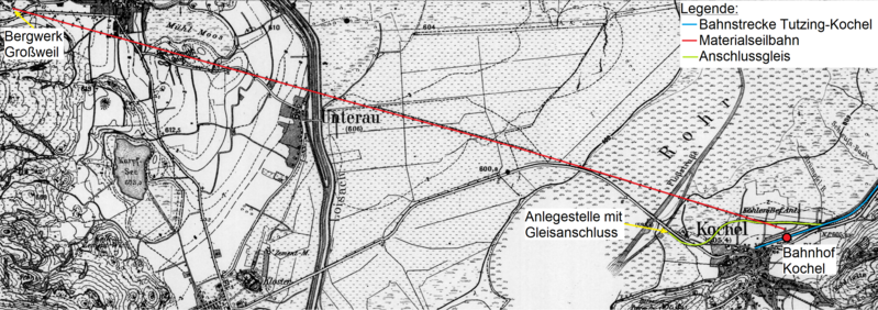
Deutsch: Die Karte zeigt den Verlauf der Materialseilbahn vom Bergwerk Großweil zum Bahnhof Kochel (rot), sowie das Anschlussgleis zur Anlegestelle am Kochelsee (grün). |
| Date | 1904, 1937, 2023 |
| Source |
Own work and using these page from the Topographische Karte Bayern: |
| Author | Peatala36 |
Licensing[edit]
- You are free:
- to share – to copy, distribute and transmit the work
- to remix – to adapt the work
- Under the following conditions:
- attribution – You must give appropriate credit, provide a link to the license, and indicate if changes were made. You may do so in any reasonable manner, but not in any way that suggests the licensor endorses you or your use.
- share alike – If you remix, transform, or build upon the material, you must distribute your contributions under the same or compatible license as the original.
The Topographische Karte Bayern 1:25.000 sheets from 1937 are in the Public Domain because their date of recording or publication is more than fifty years ago:
| Public domainPublic domainfalsefalse |
| This image is in the public domain according to German copyright law because it is part of a statute, ordinance, official decree or judgment (official work) issued by a German authority or court (§ 5 Abs.1 UrhG).
dansk ∙ Deutsch ∙ English ∙ español ∙ Esperanto ∙ français ∙ italiano ∙ Malti ∙ Nederlands ∙ polski ∙ sicilianu ∙ suomi ∙ svenska ∙ Tiếng Việt ∙ македонски ∙ русский ∙ українська ∙ বাংলা ∙ 日本語 ∙ 中文(简体) ∙ 中文(繁體) ∙ العربية ∙ +/− |
 |
File history
Click on a date/time to view the file as it appeared at that time.
| Date/Time | Thumbnail | Dimensions | User | Comment | |
|---|---|---|---|---|---|
| current | 20:12, 13 September 2023 | 3,042 × 1,074 (3.43 MB) | Peatala36 (talk | contribs) | Uploaded a work by Peatala36 from {{own}} and using these page from the Topographische Karte Bayern: * [https://www.geodaten.bayern.de/histTopoKarten/01_Positionsblatt/01_837_N_1937.pdf Positionsblatt 837] with UploadWizard |
You cannot overwrite this file.
File usage on Commons
The following 2 pages use this file:
File usage on other wikis
The following other wikis use this file:
- Usage on de.wikipedia.org
Metadata
This file contains additional information such as Exif metadata which may have been added by the digital camera, scanner, or software program used to create or digitize it. If the file has been modified from its original state, some details such as the timestamp may not fully reflect those of the original file. The timestamp is only as accurate as the clock in the camera, and it may be completely wrong.
| Horizontal resolution | 37.8 dpc |
|---|---|
| Vertical resolution | 37.8 dpc |