File:Kasei Valles and Sacra Fossae ortho-image. North is to the right ESA229378.jpg
Jump to navigation
Jump to search
Size of this preview: 800 × 338 pixels. Other resolutions: 320 × 135 pixels | 640 × 270 pixels | 1,024 × 432 pixels | 1,280 × 541 pixels | 3,500 × 1,478 pixels.
Original file (3,500 × 1,478 pixels, file size: 1.62 MB, MIME type: image/jpeg)
Captions
Captions
Add a one-line explanation of what this file represents
Summary
[edit]| Description |
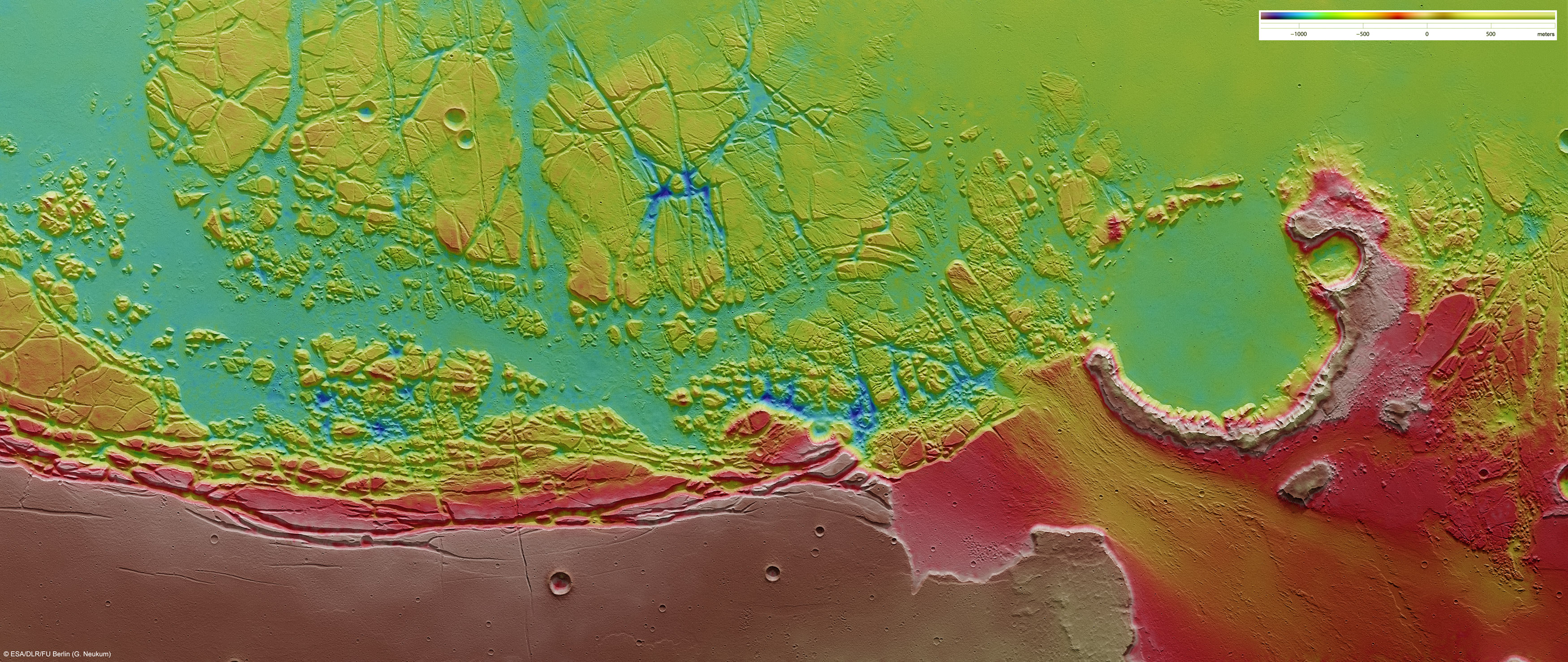
English: Mars Express flew over the boundary between Kasei Valles and Sacra Fossae and imaged the region, acquiring spectacular views of the chaotic terrain in the area. The images are centred at 12°N / 285°E and have a ground resolution of about 21 m/pixel. They cover 225 x 95 km or 21.375 sq km, an area roughly half the size of the Netherlands.
This ortho-image was rectified using elevation data derived from a high-resolution Digital Terrain Model (DTM, obtained from HRSC data), such that distortions introduced during imaging are corrected. Such an image can be used to derive maps. Elevation data from the DTM are colour-coded and overlaid on the ortho-image so that elevation data and the image itself are displayed in a single scene. The scale is in metres. |
| Date | |
| Source | http://www.esa.int/spaceinimages/Images/2009/11/Kasei_Valles_and_Sacra_Fossae_ortho-image._North_is_to_the_right |
| Author | European Space Agency |
| Permission (Reusing this file) |
ESA/DLR/FU Berlin (G. Neukum),CC BY-SA 3.0 IGO |
| Other versions |
|
| Title | Kasei Valles and Sacra Fossae ortho-image. North is to the right |
| Mission | Mars Express |
| Activity | Space Science |

Licensing
[edit]
This file is licensed under the Creative Commons Attribution-ShareAlike 3.0 IGO license.
Attribution: ESA/DLR/FU Berlin (G. Neukum)
- You are free:
- to share – to copy, distribute and transmit the work
- to remix – to adapt the work
- Under the following conditions:
- attribution – You must give appropriate credit, provide a link to the license, and indicate if changes were made. You may do so in any reasonable manner, but not in any way that suggests the licensor endorses you or your use.
- share alike – If you remix, transform, or build upon the material, you must distribute your contributions under the same or compatible license as the original.
File history
Click on a date/time to view the file as it appeared at that time.
| Date/Time | Thumbnail | Dimensions | User | Comment | |
|---|---|---|---|---|---|
| current | 15:43, 24 May 2017 | | 3,500 × 1,478 (1.62 MB) | Fæ (talk | contribs) | European Space Agency, Id 229378, http://www.esa.int/spaceinimages/Images/2009/11/Kasei_Valles_and_Sacra_Fossae_ortho-image._North_is_to_the_right, User:Fæ/Project_list/ESA |
You cannot overwrite this file.
File usage on Commons
The following page uses this file:
File usage on other wikis
The following other wikis use this file:
- Usage on fr.wikipedia.org