File:Lake Silvaplana and St. Moritz-Bad as seen from Muttaun 2.jpg
Jump to navigation
Jump to search

Size of this preview: 800 × 208 pixels. Other resolutions: 320 × 83 pixels | 640 × 166 pixels | 1,024 × 266 pixels | 1,280 × 333 pixels | 2,560 × 665 pixels | 13,360 × 3,472 pixels.
Original file (13,360 × 3,472 pixels, file size: 36.83 MB, MIME type: image/jpeg)
Captions
Captions
Add a one-line explanation of what this file represents
Summary[edit]
| Description |
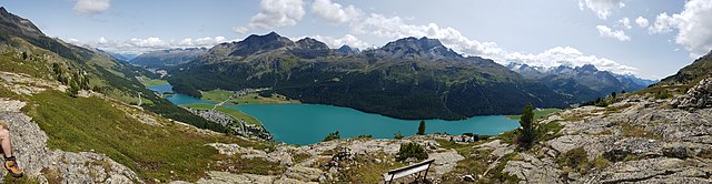
English: Lej da Silvaplauna, Lej Suot, Lej da Champfèr and St. Moritz-Bad, picture taken from Muttaun (Silvaplana, Grison, Switzerland). In the background Piz Corvatsch, Piz Surlej and Piz Rosatsch.
Deutsch: Silvaplanersee, Lej Suot, Lej da Champfèr und St. Moritz-Bad, aufgenommen von Muttaun (Silvaplana, Graubünden, Schweiz). Im Hintergrund Piz Corvatsch, Piz Surlej and Piz Rosatsch.
Rumantsch: Lej da Silvaplauna, Lej Suot, Lej da Champfèr e San Murezzan Bagn, piglia se davent da Muttaun (Silvaplauna, Grischun, Svizra). Davos ve Piz Corvatsch, Piz Surlej and Piz Rosatsch.
Italiano: Lej da Silvaplauna, Lej Suot, Lej da Champfèr e St. Moritz-Bad, fotografato da Muttaun (Silvaplana, Grigioni, Svizzera). Sullo sfondo Piz Corvatsch, Piz Surlej and Piz Rosatsch. |
||
| Date | |||
| Source |
Own work
|
||
| Author | Capricorn4049 | ||
| Permission (Reusing this file) |
|

| Camera location | | View this and other nearby images on: OpenStreetMap |
|---|
| Object location | | View this and other nearby images on: OpenStreetMap |
|---|
Licensing[edit]
This file is licensed under the Creative Commons Attribution-Share Alike 4.0 International license.
- You are free:
- to share – to copy, distribute and transmit the work
- to remix – to adapt the work
- Under the following conditions:
- attribution – You must give appropriate credit, provide a link to the license, and indicate if changes were made. You may do so in any reasonable manner, but not in any way that suggests the licensor endorses you or your use.
- share alike – If you remix, transform, or build upon the material, you must distribute your contributions under the same or compatible license as the original.
| Annotations | This image is annotated: View the annotations at Commons |
File history
Click on a date/time to view the file as it appeared at that time.
| Date/Time | Thumbnail | Dimensions | User | Comment | |
|---|---|---|---|---|---|
| current | 23:28, 22 August 2017 | 13,360 × 3,472 (36.83 MB) | Capricorn4049 (talk | contribs) |
You cannot overwrite this file.
File usage on Commons
The following page uses this file:
File usage on other wikis
The following other wikis use this file:
- Usage on de.wikipedia.org
- Usage on pt.wikipedia.org