File:Map Crusader states 1240-fr.svg
(Redirected from File:Levant 1240-fr.svg)

Size of this PNG preview of this SVG file: 440 × 599 pixels. Other resolutions: 176 × 240 pixels | 353 × 480 pixels | 564 × 768 pixels | 752 × 1,024 pixels | 1,505 × 2,048 pixels | 507 × 690 pixels.
Original file (SVG file, nominally 507 × 690 pixels, file size: 636 KB)
Captions
Captions
Add a one-line explanation of what this file represents
Summary[edit]
| Description |
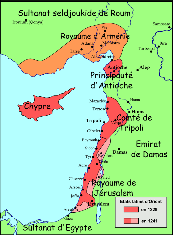
Français : Carte politique du Proche-Orient de 1229 à 1241 |
| Date | |
| Source |
travail personnel (own work) Modifications from  |
| Author | Odejea |
| Other versions |
[]
See also[edit] |


Licensing[edit]
I, the copyright holder of this work, hereby publish it under the following licenses:

|
Permission is granted to copy, distribute and/or modify this document under the terms of the GNU Free Documentation License, Version 1.2 or any later version published by the Free Software Foundation; with no Invariant Sections, no Front-Cover Texts, and no Back-Cover Texts. A copy of the license is included in the section entitled GNU Free Documentation License. |
This file is licensed under the Creative Commons Attribution-Share Alike 3.0 Unported, 2.5 Generic, 2.0 Generic and 1.0 Generic license.
- You are free:
- to share – to copy, distribute and transmit the work
- to remix – to adapt the work
- Under the following conditions:
- attribution – You must give appropriate credit, provide a link to the license, and indicate if changes were made. You may do so in any reasonable manner, but not in any way that suggests the licensor endorses you or your use.
- share alike – If you remix, transform, or build upon the material, you must distribute your contributions under the same or compatible license as the original.
You may select the license of your choice.
File history
Click on a date/time to view the file as it appeared at that time.
| Date/Time | Thumbnail | Dimensions | User | Comment | |
|---|---|---|---|---|---|
| current | 19:57, 22 August 2008 | | 507 × 690 (636 KB) | Odejea (talk | contribs) | == Description == {{Information |Description={{en|1=A political map of the w:en:Near East from 1229 until 1241 CE.}} {{fr|1=Carte politique du Proche-Orient de 1229 à 1241 }} |Source=travail personnel (own w |
You cannot overwrite this file.
File usage on Commons
The following 8 pages use this file:
- File:Levant 1240-fr.svg (file redirect)
- File:Map Crusader states 1240-de.svg
- File:Map Crusader states 1240-eng.png
- File:Map Crusader states 1240-fr.svg
- File:Map Crusader states 1240-fr2.svg
- File:Map Crusader states 1240-it.svg
- File:Map Crusader states 1240-pt.svg
- Template:Other versions/Map Crusader states 1240
File usage on other wikis
The following other wikis use this file:
- Usage on cs.wikipedia.org
- Usage on eu.wikipedia.org
- Usage on fa.wikipedia.org
- Usage on fi.wikipedia.org
- Usage on fr.wikipedia.org
- Usage on it.wikipedia.org
- Usage on nl.wikipedia.org
- Usage on oc.wikipedia.org
- Usage on sr.wikipedia.org