File:Locations of Major League Soccer teams.svg
Jump to navigation
Jump to search

Size of this PNG preview of this SVG file: 800 × 527 pixels. Other resolutions: 320 × 211 pixels | 640 × 422 pixels | 1,024 × 675 pixels | 1,280 × 844 pixels | 2,560 × 1,687 pixels | 836 × 551 pixels.
Original file (SVG file, nominally 836 × 551 pixels, file size: 625 KB)
Captions
Captions
Locations of Major League Soccer teams
Summary[edit]
| Description |
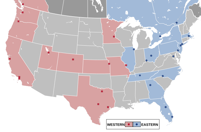
English: Major League Soccer (MLS) Divisions. The locations of Eastern Division teams are marked with circles and the locations of Western Division teams are marked with circles. Inside each are a small black circle/square indicating the exact location of each team's stadium. States and provinces that host a team are highlighted.
Eastern Division
Western Division |
| Date | |
| Source | Derived from File:North America map with states and provinces.svg by Kaldari and Halava |
| Author | Spesh531 |
Licensing[edit]
This file is licensed under the Creative Commons Attribution-Share Alike 4.0 International license.
- You are free:
- to share – to copy, distribute and transmit the work
- to remix – to adapt the work
- Under the following conditions:
- attribution – You must give appropriate credit, provide a link to the license, and indicate if changes were made. You may do so in any reasonable manner, but not in any way that suggests the licensor endorses you or your use.
- share alike – If you remix, transform, or build upon the material, you must distribute your contributions under the same or compatible license as the original.
File history
Click on a date/time to view the file as it appeared at that time.
| Date/Time | Thumbnail | Dimensions | User | Comment | |
|---|---|---|---|---|---|
| current | 01:18, 23 October 2023 | | 836 × 551 (625 KB) | IagoQnsi (talk | contribs) | fix width |
| 01:14, 23 October 2023 |  | 838 × 550 (625 KB) | IagoQnsi (talk | contribs) | Alaska/Hawaii inset not needed since no teams play there (kept code with display:none just in case) | |
| 23:26, 5 July 2023 |  | 836 × 595 (625 KB) | Spesh531 (talk | contribs) | Adding British Columbia highlight in the bottom left box | |
| 03:32, 4 July 2023 |  | 836 × 595 (616 KB) | Spesh531 (talk | contribs) | Uploaded a work by Spesh531 from Derived from File:North America map with states and provinces.svg by Kaldari and Halava with UploadWizard |
You cannot overwrite this file.
File usage on Commons
The following 3 pages use this file:
File usage on other wikis
The following other wikis use this file:
- Usage on en.wikipedia.org
- Usage on uk.wikipedia.org