File:Lombardian Alps and Prealps WV region map.svg
Jump to navigation
Jump to search

Size of this PNG preview of this SVG file: 409 × 489 pixels. Other resolutions: 201 × 240 pixels | 401 × 480 pixels | 642 × 768 pixels | 856 × 1,024 pixels | 1,713 × 2,048 pixels.
Original file (SVG file, nominally 409 × 489 pixels, file size: 1.9 MB)
Captions
Captions
Add a one-line explanation of what this file represents
Summary[edit]
| Description |
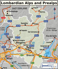
English: SVG base map of the Lombardian Alps and Prealps travel region used in English Wikivoyage, including the major destinations and transportation routes. Orange and yellow roads denote an Autostrada, orange roads are state highways, brown roads are all other types of roads. Map projection is Mercator. Català: Mapa base SVG de la regió de viatges dels Alps de Llombarda i dels Prealps utilitzat a Wikivoyage en anglès, incloses les principals destinacions i rutes de transport. Les carreteres taronges i grogues denoten una autopista, les carreteres taronges són carreteres estatals, les carretes marrons són tots els altres tipus de carreteres. La projecció del mapa és Mercator. |
| Date | |
| Source |
Own work, based on data from the following sources:
|
| Author | Shaundd |
| Other versions |
|


Licensing[edit]
I, the copyright holder of this work, hereby publish it under the following license:
This file is licensed under the Creative Commons Attribution-Share Alike 4.0 International license.
- You are free:
- to share – to copy, distribute and transmit the work
- to remix – to adapt the work
- Under the following conditions:
- attribution – You must give appropriate credit, provide a link to the license, and indicate if changes were made. You may do so in any reasonable manner, but not in any way that suggests the licensor endorses you or your use.
- share alike – If you remix, transform, or build upon the material, you must distribute your contributions under the same or compatible license as the original.
File history
Click on a date/time to view the file as it appeared at that time.
| Date/Time | Thumbnail | Dimensions | User | Comment | |
|---|---|---|---|---|---|
| current | 17:24, 18 September 2023 | | 409 × 489 (1.9 MB) | Solde (talk | contribs) | File uploaded using svgtranslate tool (https://svgtranslate.toolforge.org/). Added translation for ca. |
| 04:51, 12 June 2015 |  | 409 × 489 (1.84 MB) | Shaundd (talk | contribs) | improve visibility of some railroads | |
| 21:02, 31 May 2015 |  | 409 × 489 (1.84 MB) | Shaundd (talk | contribs) | fix bounding box | |
| 20:51, 31 May 2015 |  | 698 × 661 (1.84 MB) | Shaundd (talk | contribs) | User created page with UploadWizard |
You cannot overwrite this file.
File usage on Commons
The following 3 pages use this file:
File usage on other wikis
The following other wikis use this file:
- Usage on ca.wikipedia.org