File:London 1724.jpg

Original file (874 × 608 pixels, file size: 150 KB, MIME type: image/jpeg)
Captions
Captions
Summary
[edit]| English: Midlesex by H. Moll Geographer
( |
|||||||||||||||||||||||||||
|---|---|---|---|---|---|---|---|---|---|---|---|---|---|---|---|---|---|---|---|---|---|---|---|---|---|---|---|
| Author |
|
||||||||||||||||||||||||||
| Title |
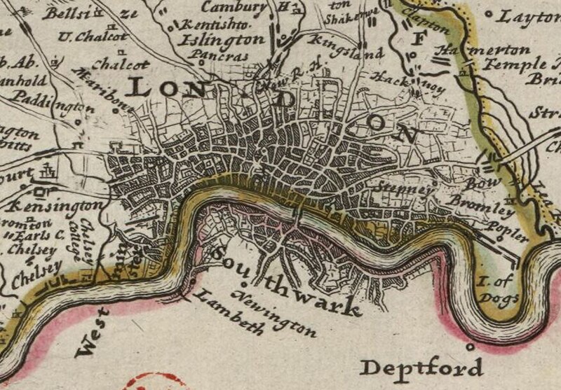
English: Midlesex by H. Moll Geographer |
||||||||||||||||||||||||||
| Description |
English: Detail of London from Moll's map of Middlesex, sold separately and as Map 19 in his Set of Fifty New and Correct Maps of England and Wales...
Français : Sujet : Antiquités romaines
Colonnes Châteaux Divisions politiques et administratives Middlesex, Comté du -- Divisions politiques et administratives Londres Kensington, Château de Hampton Court Échelle(s) : 5 English Miles [= 4,5 cm] Référence bibliographique : 173 Appartient à l’ensemble documentaire : AnvilEur Appartient à l’ensemble documentaire : MAEDI008 Appartient à l’ensemble documentaire : MAEDIGen0 Couverture : Royaume-Uni – Angleterre – Grand Londres Langue : anglais Éditeur : [T. Bowles] (London) |
||||||||||||||||||||||||||
| Date | 1724 | ||||||||||||||||||||||||||
| Dimensions | height: 34 cm (13.3 in); width: 23 cm (9 in) | ||||||||||||||||||||||||||
| Collection |
|
||||||||||||||||||||||||||
| References |
Français : Notice de recueil : http://catalogue.bnf.fr/ark:/12148/cb40577015h
Appartient à : Collection d'Anville ; 02225 Notice du catalogue : http://catalogue.bnf.fr/ark:/12148/cb41247758q Extrait de A New Description of England and Wales, With the Adjacent Islands, 1724. |
||||||||||||||||||||||||||
| Source/Photographer |
Français : Bibliothèque nationale de France, département Cartes et plans, GE DD-2987 (2225)
Bibliothèque nationale de France |
||||||||||||||||||||||||||
| Permission (Reusing this file) |
|
||||||||||||||||||||||||||
| Other versions |
|
||||||||||||||||||||||||||


| Annotations | This image is annotated: View the annotations at Commons |
File history
Click on a date/time to view the file as it appeared at that time.
| Date/Time | Thumbnail | Dimensions | User | Comment | |
|---|---|---|---|---|---|
| current | 12:50, 25 November 2023 | | 874 × 608 (150 KB) | LlywelynII (talk | contribs) | File:Midlesex - By H. Moll Geographer - btv1b530568320.jpg cropped. |
You cannot overwrite this file.
File usage on Commons
The following 2 pages use this file: