File:Long Sault Parkway-map.pdf
Jump to navigation
Jump to search

Size of this JPG preview of this PDF file: 800 × 253 pixels. Other resolutions: 320 × 101 pixels | 640 × 202 pixels | 1,650 × 522 pixels.
Original file (1,650 × 522 pixels, file size: 109 KB, MIME type: application/pdf)
Captions
Captions
Add a one-line explanation of what this file represents
Summary[edit]
| Description |
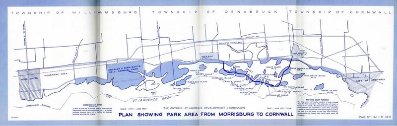
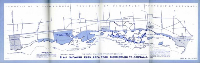
English: Drawing of the proposed w:Long Sault Parkway. |
| Date | June 15, 1956 |
| Source | Courtesy of Jeri Danyleyko, Ghost Towns in Canada |
| Author | Ontario–St. Lawrence Development Commission |
Licensing[edit]
| This Canadian work is in the public domain worldwide because it was subject to Crown copyright and was first published before December 31, 1973.
According to Public Works and Government Services Canada / Travaux publics et Services gouvernementaux Canada, Canada has no intention of renewing expired Crown Copyright works in any country, and consequently the URAA does not apply. An email is on record at ticket:2013122310013986. |
 | |
|
| ||
File history
Click on a date/time to view the file as it appeared at that time.
| Date/Time | Thumbnail | Dimensions | User | Comment | |
|---|---|---|---|---|---|
| current | 17:39, 28 April 2021 | 1,650 × 522 (109 KB) | Floydian (talk | contribs) | crop pdf | |
| 17:33, 28 April 2021 |  | 1,650 × 1,275 (109 KB) | Floydian (talk | contribs) | == Summary == {{Information | description = | source = Courtesy of Jeri Danyleyko, [https://www.ghosttownpix.com/index.html Ghost Towns in Canada] | date = June 15, 1956 | author = Ontario–St. Lawrence Development Commission | permission = {{PD-Canada-Crown}} | other_versions = }} {{Keep local}} |
You cannot overwrite this file.
File usage on Commons
The following page uses this file:
File usage on other wikis
The following other wikis use this file:
- Usage on en.wikipedia.org