File:Lower mainland.png
Jump to navigation
Jump to search
Size of this preview: 800 × 581 pixels. Other resolutions: 320 × 232 pixels | 640 × 465 pixels | 1,024 × 744 pixels | 1,280 × 930 pixels | 2,132 × 1,549 pixels.
Original file (2,132 × 1,549 pixels, file size: 819 KB, MIME type: image/png)
Captions
Captions
Add a one-line explanation of what this file represents
Summary[edit]
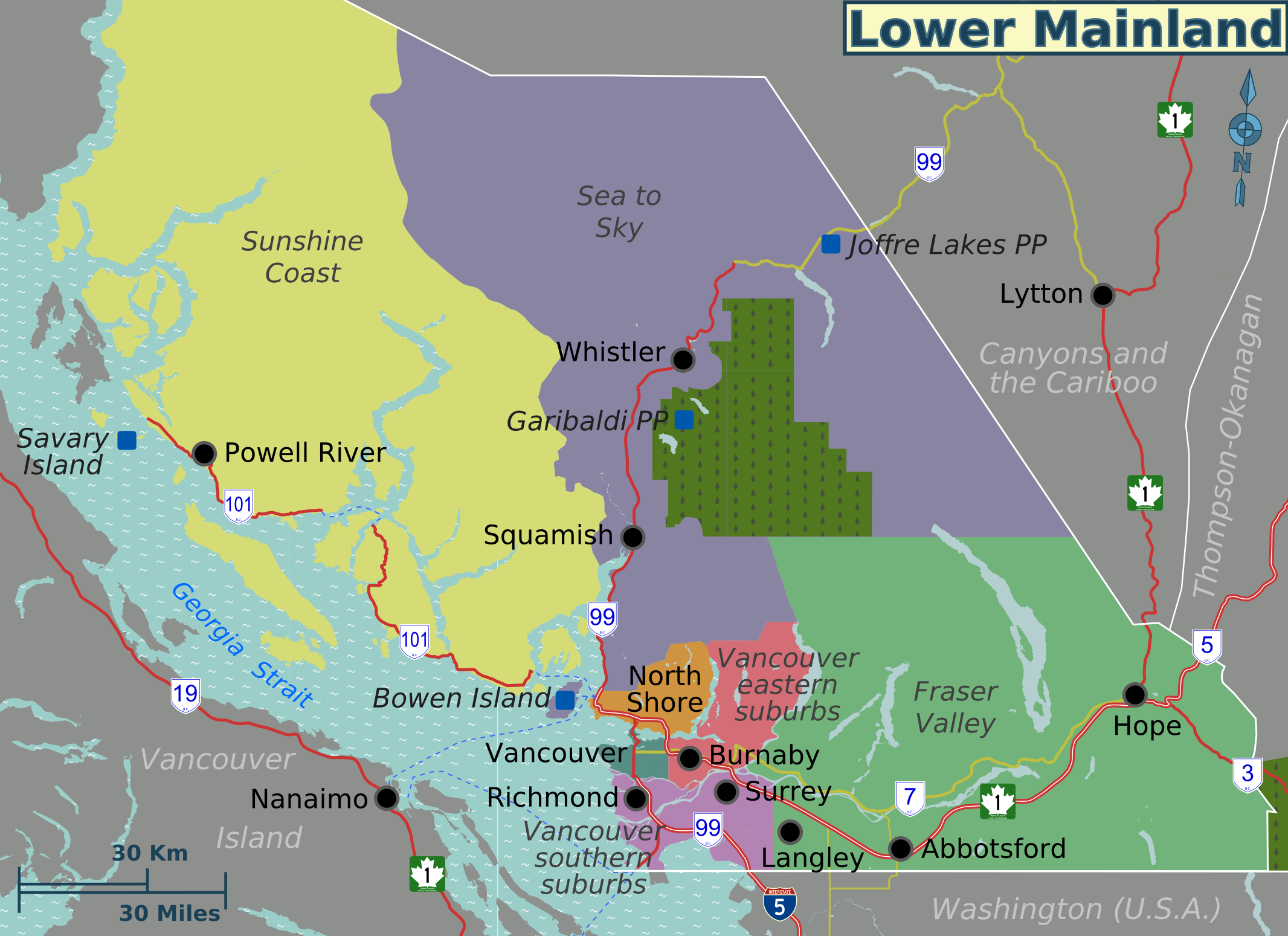
| Description | Map of regions in the Lower Mainland (British Columbia) for use on Wikivoyage, English version |
| Date | |
| Source | Own work based on OpenStreetMap |
| Author | Shaund |
| Other versions | SVG base file |
Licensing[edit]
This file is licensed under the Creative Commons Attribution-Share Alike 4.0 International, 3.0 Unported, 2.5 Generic, 2.0 Generic and 1.0 Generic license.
- You are free:
- to share – to copy, distribute and transmit the work
- to remix – to adapt the work
- Under the following conditions:
- attribution – You must give appropriate credit, provide a link to the license, and indicate if changes were made. You may do so in any reasonable manner, but not in any way that suggests the licensor endorses you or your use.
- share alike – If you remix, transform, or build upon the material, you must distribute your contributions under the same or compatible license as the original.
Original upload log[edit]
| This file was imported from Wikivoyage WTS. |
The original description page was here. All following user names refer to wts.wikivoyage-old.
- 2008-08-25 00:11 (WT-shared) Shaund archive copy at the Wayback Machine 1135×755 (166737 bytes) Map of regions in the Lower Mainland. Map created by ~~~~. {{location|British Columbia}} ===Source=== Source file is [[Image:Lower_Mainlan (Import from wikitravel.org/shared)
- 2010-01-10 20:21 (WT-shared) Shaund archive copy at the Wayback Machine 2132×1549 (838436 bytes) (Import from wikitravel.org/shared)
File history
Click on a date/time to view the file as it appeared at that time.
| Date/Time | Thumbnail | Dimensions | User | Comment | |
|---|---|---|---|---|---|
| current | 14:10, 26 November 2012 | | 2,132 × 1,549 (819 KB) | OgreBot (talk | contribs) | (BOT): Reverting to most recent version before archival |
| 14:10, 26 November 2012 |  | 1,135 × 755 (163 KB) | OgreBot (talk | contribs) | (BOT): Uploading old version of file from wts.wikivoyage-old; originally uploaded on 2008-08-25 00:11:24 by (WT-shared) Shaund | |
| 00:42, 18 November 2012 |  | 2,132 × 1,549 (819 KB) | MGA73bot2 (talk | contribs) | {{BotMoveToCommons|wts.oldwikivoyage|year={{subst:CURRENTYEAR}}|month={{subst:CURRENTMONTHNAME}}|day={{subst:CURRENTDAY}}}} == {{int:filedesc}} == {{Information |description=. Map of regions in the Lower Mainland., British Columbia * Map of: Lower Main... |
You cannot overwrite this file.
File usage on Commons
There are no pages that use this file.
File usage on other wikis
The following other wikis use this file:
- Usage on en.wikipedia.org
- Usage on en.wikivoyage.org
- Usage on he.wikivoyage.org
- Usage on it.wikivoyage.org
- Usage on ru.wikivoyage.org