File:Map Union of Arras and Utrecht 1579-nl.svg
Jump to navigation
Jump to search

Size of this PNG preview of this SVG file: 515 × 600 pixels. Other resolutions: 206 × 240 pixels | 412 × 480 pixels | 660 × 768 pixels | 879 × 1,024 pixels | 1,759 × 2,048 pixels | 749 × 872 pixels.
Original file (SVG file, nominally 749 × 872 pixels, file size: 139 KB)
Captions
Captions
Add a one-line explanation of what this file represents
Summary[edit]

| Description |
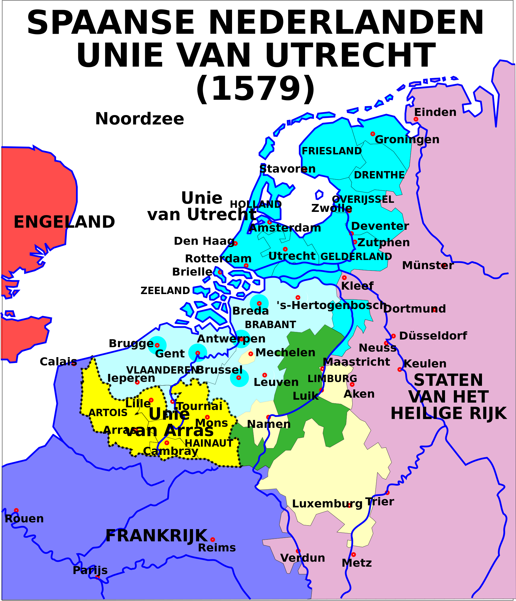
English: Map of the Union of Utrecht in 1579 with Dutch text
Nederlands: Kaart van de Unie van Utrecht in 1579 met Nederlandstalige text |
| Date | 31 May 2006 15:23 and 11 September 2006 |
| Source | Image:1579 Union of Utrecht.svg |
| Author | Moyogo and Siebrand |
| Permission (Reusing this file) |
Creative Commons Attribution ShareAlike 2.5 |
| Other versions |
[]
|


Licensing[edit]
This file is licensed under the Creative Commons Attribution-Share Alike 2.5 Generic license.
- You are free:
- to share – to copy, distribute and transmit the work
- to remix – to adapt the work
- Under the following conditions:
- attribution – You must give appropriate credit, provide a link to the license, and indicate if changes were made. You may do so in any reasonable manner, but not in any way that suggests the licensor endorses you or your use.
- share alike – If you remix, transform, or build upon the material, you must distribute your contributions under the same or compatible license as the original.
File history
Click on a date/time to view the file as it appeared at that time.
| Date/Time | Thumbnail | Dimensions | User | Comment | |
|---|---|---|---|---|---|
| current | 13:39, 11 September 2006 | | 749 × 872 (139 KB) | Siebrand (talk | contribs) | {{Information| |Description={{en|Map of the Union of Utrecht in 1579 with Dutch text}} {{nl|Kaart van de Unie van Utrecht in 1579 met Nederlandstalige text}} |Source=Image:1579 Union of Utrecht.svg |Date=31 May 2006 15:23 and 11 September 2006 |Autho |
You cannot overwrite this file.
File usage on Commons
The following 10 pages use this file:
- File:1579 Union of Utrecht nl.svg (file redirect)
- File:Map Union of Arras and Utrecht 1579-bg.svg
- File:Map Union of Arras and Utrecht 1579-en.svg
- File:Map Union of Arras and Utrecht 1579-es.svg
- File:Map Union of Arras and Utrecht 1579-fr.svg
- File:Map Union of Arras and Utrecht 1579-gl.svg
- File:Map Union of Arras and Utrecht 1579-hu.svg
- File:Map Union of Arras and Utrecht 1579-nl.svg
- File:Map Union of Arras and Utrecht 1579-no.svg
- Template:Other versions/Map Union of Arras and Utrecht 1579
File usage on other wikis
The following other wikis use this file:
- Usage on af.wikipedia.org
- Usage on id.wikipedia.org
- Usage on nl.wikipedia.org
- Usage on vls.wikipedia.org