File:Map of Ancient Arabia WDL2923.png
Jump to navigation
Jump to search
Size of this preview: 723 × 599 pixels. Other resolutions: 290 × 240 pixels | 579 × 480 pixels | 926 × 768 pixels | 1,235 × 1,024 pixels.
Original file (1,235 × 1,024 pixels, file size: 2.25 MB, MIME type: image/png)
Captions
Captions
Add a one-line explanation of what this file represents
Summary[edit]
| Author |
Русский: Вейгель, Кристоф (1654-1725)
Français : Weigel, Christoph (1654-1725)
English: Weigel, Christoph (1654-1725)
中文:魏格尔, 克里斯托夫 (1654-1725)
Português: Weigel, Christoph (1654-1725)
العربية: ويجل, كريستوف (1654-1725)
Español: Weigel, Christoph (1654-1725) |
| Title |
Русский: Карта древней Аравии
Français : Carte de l'Arabie Antique
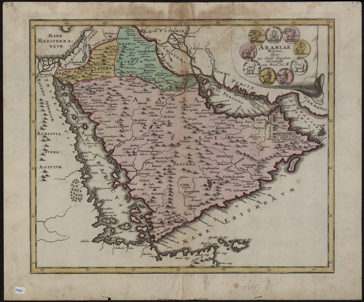
English: Map of Ancient Arabia
中文:古阿拉伯地图
Português: Mapa da Arábia Antiga
العربية: خريطة شبه الجزيرة العربية القديمة
Español: Mapa de la Antigua Arabia |
| Description |
Русский: На этой карте Аравийского полуострова, изданной в 1720 году, изображены Аравия Феликс, Аравия Пустынная и Аравия Каменистая. Отмечены также такие регионы как Палестина, Месопотамия, Халдея, Персия, Египет и Эфиопия. Обозначено множество городов. На картуше заголовка девять монетных виньеток. Названия племен и городов такие же, как у Птолемея. Некоторые из них используются не один раз, иногда с вариациями. Например, "Indicara", "Iacara", "Ichara" и "Aphana" могут обозначать одно и то же место, а именно землю, выбранную Александром Македонским для строительства столицы на острове Аравийского залива с целью обретения контроля над торговлей в регионе и расширения империи (эта цель не была достигнута). Археологические раскопки свидетельствуют о том, что это место было островом Файлака на территории современного Кувейта, хотя некоторые историки называют остров Абу-Али. На карте показан полуостров вблизи современного Бахрейна. Острова "Arathos" и "Thylaso" — это острова Мухарраке и Бахрейн, соответственно. На самом деле они расположены к югу от Катара. На этой карте они размещены со стороны Персидского побережья, возможно по той причине, что картограф спутал их с Хормузом и Кишмом. Катар обозначен на карте как Катара, но его очертания и местонахождение не верны. Эта карта была создана Кристофом Вейгелем — немецким гравером, торговцем предметами искусства и издателем.
Аравийский залив; Аравийский полуостров; Персидский залив Français : Cette carte de la Péninsule Arabique, publiée en 1720, montre Arabia Felix, Arabia Deserta, et Arabia Petraea. On trouve d'autres régions comme la Palestine, la Mésopotamie, la Chaldée, la Perse, Aegyptus, et Aethiopia. Un grand nombre de villes sont indiquées. La cartouche de titre comprend neuf pièces de monnaie en vignettes. Les noms de ville et de tribu sur la carte sont ceux utilisés par Ptolémée. Certains sont utilisés plus d'une fois, avec des variations. Ainsi, “Indicara,” “Iacara,” “Ichara,” et “Aphana” peuvent tous indiquer le même lieu : le site où Alexandre le Grand souhaitait construire une capitale sur une île dans le Golfe Arabique, lui permettant de prendre le contrôle des échanges commerciaux de la région et d'étendre son empire (un plan qu'il ne fut pas en mesure de mettre en œuvre avant sa mort). La recherche archéologique suggère que ce site était l'Île de Failakash dans l'actuel Koweït, bien que certains historiens la placent sur l'Île d'Abu Ali. La carte montre une péninsule proche de l'actuelle Bahreïn. Les îles d'“Arathos” et de “Thylaso” indiquent respectivement les îles de Muharraq et de Bahreïn, qui sont en fait situées au nord du Qatar. Sur cette carte, elles sont placées du côté du littoral persique, probablement parce que le cartographe les a confondues avec “Ormuz” et “Qishm.” Le Qatar est mentionné sur la carte comme "Catara", mais sa forme et son emplacement son inexacts. La carte est de Christoph Weigel, un graveur, marchand d'art et éditeur allemand.
Golfe Arabique; Péninsule arabique; Golfe Persique English: This map of the Arabian Peninsula, published in 1720, shows Arabia Felix, Arabia Deserta, and Arabia Petraea. Other regions included are Palestine, Mesopotamia, Chaldea, Persia, Aegyptus, and Aethiopia. A large number of towns are shown. The title cartouche includes nine vignette coins. The tribal and town names on the map are those used by Ptolemy. Some are used more than once, with variations. Thus “Indicara,” “Iacara,” “Ichara,” and “Aphana” all could indicate the same place: the spot where Alexander the Great intended to build a capital on an island in the Arabian Gulf, enabling him to control the trade of the region and extend his empire (a scheme that he was unable to accomplish before he died). Archeological research suggests that this place was Failakah Island in present-day Kuwait, although some historians place it at Abu Ali Island. The map shows a peninsula near present-day Bahrain. The islands of “Arathos” and “Thylaso” indicate Muharraq and Bahrain islands, respectively, which are actually located north of Qatar. On this map, they are placed on the Persian coast side, probably because the cartographer confused them with “Hormuz” and “Qishm.” Qatar is mentioned on the map as “Catara,” but its shape and location are not accurate. The map is by Christoph Weigel, a German engraver, art dealer, and publisher.
Arabian Gulf; Arabian Peninsula; Persian Gulf 中文:这幅阿拉伯半岛地图出版于 1720 年,描绘的是福地阿拉伯(Arabia Felix)、沙漠阿拉伯(Arabia Deserta)和多岩阿拉伯(Arabia Petraea)。 该地图所涵盖的其他地区还包括巴勒斯坦、美索不达米亚、卡尔迪亚、波斯、埃古普托斯和埃西欧匹亚。 该地图标注了大量的城镇。 标题的涡卷装饰共包含九种花饰设计图案。 该地图使用的是托勒密曾使用的部落和城镇名称。 一些名称采用不同的变体,使用了不止一次。 因此,“Indicara” 、“Iacara” 、“Ichara”和“Aphana”可能指示的是同一个地方:这里是亚历山大大帝想在阿拉伯海湾的一处岛屿上建都的地点,为的是他自己能控制该地区的贸易,实现帝国的扩张(亚历山大大帝生前并没能完成这一计划)。 考古研究表明该地点是位于当今科威特境内的 Failakah 岛,也有一些史学家认为是阿布阿里岛。 该地图上显示有位于当今巴林附近的一处半岛。 “Arathos”和“Thylaso”分别表示的是穆哈拉格岛和巴林群岛,这些岛屿实际上位于卡特尔的北面。 而在该地图上,这些岛屿位于波斯湾的沿海一侧,可能是制图师将这些岛屿与“霍尔木兹”和“格什姆”混淆了。 该地图上的卡塔尔被称作“Catara”,但是其形状和位置都不准确。 该地图是德国雕刻师、艺术品商人兼出版商克里斯托夫·韦格尔的作品。
阿拉伯湾; 阿拉伯半岛; 波斯湾 Português: Este mapa da Península Árabe, publicado em 1720, mostra Arabia Felix, Arabia Deserta e Arabia Petraea. Outras regiões incluídas são: Palestina, Mesopotâmia, Caldeia, Pérsia, Egito e Etiópia. Um grande número de cidades são mostradas. A cártula título inclui nove vinhetas de moedas. Os nomes tribais e de cidades no mapa são aqueles utilizados por Ptolomeu. Alguns são utilizados mais de uma vez, com variações. Dessa forma, "Indicara", "Iacara", "Ichara" e "Aphana", todos podem indicar o mesmo ponto: o local onde Alexandre o Grande pretendia construir uma capital em uma ilha do Golfo Árabe, permitindo-lhe controlar o comércio da região e ampliar seu império (um projeto que ele foi incapaz de realizar antes de morrer). A pesquisa arqueológica sugere que este local era a Ilha de Failakah, no atual Kuwait, apesar de alguns historiadores situarem-no na Ilha de Abu Ali. O mapa mostra uma península próxima do atual Bahrain. As ilhas de "Arathos" e "Thylaso" indicam as ilhas de Muharraq e de Bahrain, respectivamente, que são na verdade localizadas ao norte de Catar. Neste mapa, elas estão localizadas no lado costeiro persa, provavelmente porque o cartógrafo as confundiu com "Hormuz" e "Qishm". Menciona-se Catar no mapa como "Catara," porém sua forma e localização não são exatas. O mapa é de Christoph Weigel, um gravador, marchand e editor alemão.
Golfo Arábico; Península Arábica; Golfo Pérsico العربية: نُشرت هذه الخريطة لشبه الجزيرة العربية عام 1720، وهي تظهر العربية السعيدة، والعربية البترائية. كما تشمل مناطق أخرى مثل فلسطين وبلاد ما بين النهرين وكلديا وبلاد فارس ومصر والحبشة. وهناك عدد كبير من البلدات. يحتوي إطار العنوان على تسع قطع نقود مزخرفة. تستعمل الخريطة نفس أسماء القبائل والمدن التي استخدمها بطليموس. كما يدرج بعضها أكثر من مرة، مع بعض الفوارق. إذًا، يمكن أن تشير كل من "إنديكارا" و"إشارة" و"أفانة" إلى نفس المكان: حيث كان ألكسندر الكبير ينوي بناء عاصمة على جزيرة في الخليج العربي، مما يمكنه من السيطرة على التجارة في المنطقة وتوسيع إمبراطوريته (وهو مخطط لم يتمكن من تحقيقه قبل وفاته). وتشير الأبحاث الأثرية إلى أن هذا المكان كان جزيرة فيلكة في الكويت حاليا، على الرغم من أن بعض المؤرخين يرجحون بأن المكان هو جزيرة أبو علي. تظهر الخريطة شبه جزيرة بالقرب من البحرين حاليا. وتدل جزر "أراثوس" و"ثيلاسو" على جزيرتي محرق والبحرين على التوالي والتي تقعان إلى الشمال من قطر. وُضعت الجزيرتان على هذه الخريطة على جانب الساحل الفارسي، ربما نتيجة اختلاط الأسماء مع "هرمز" و"قشم" لدى رسام الخرائط. وتُذكر قطر على الخريطة باسم "كاتارا" ، ولكن شكلها ومكانها ليس دقيق. والخريطة من وضع كريستوف فايغل، وهو نقاش وتاجر تحف فنية وناشر ألماني.
الخليج العربي; شبه الجزيرة العربية; الخليج الفارسي Español: Este mapa de la península Arábiga, publicado en 1720, muestra la Arabia Felix, Arabia Deserta y Arabia Petraea. Otras regiones incluidas son Palestina, Mesopotamia, Caldea, Persia, Aegyptus y Aethiopia. Se muestra un gran número de ciudades. La orla del título incluye nueve monedas viñetas. Los nombres tribales y de ciudades en el mapa son los utilizados por Ptolomeo. Algunos se utilizan más de una vez, con variaciones. Por lo tanto “Indicara”, “Iacara”, “Ichara” y “Aphana” podrían indicar el mismo lugar: el lugar donde Alejandro Magno pensó en construir una capital en una isla en el Golfo Arábigo, que le permitiese controlar el comercio de la región y ampliar su imperio (un proyecto que no pudo llevar a cabo antes de su muerte). La investigación arqueológica sugiere que este lugar fue la Isla Failakah en el actual Kuwait, aunque algunos historiadores lo colocan en la isla de Abu Ali. El mapa muestra una península cerca de la actual Bahrein. Las islas de "Arathos" y "Thylaso" indican las islas Muharraq y Bahrain, respectivamente, que están ubicadas al norte de Catar. En este mapa, están ubicadas en el lado persa de la costa, probablemente debido a que el cartógrafo las confundió con "Ormuz" y "Qishm". Catar se menciona en el mapa como "Catara", pero su forma y ubicación no son exactas. El mapa es de Christoph Weigel, un grabador alemán, comerciante de arte y editor.
Golfo Arábigo; Península de Arabia; Golfo Pérsico |
| Date | 1720 |
| Medium |
Русский: Карты
Français : Cartes
English: Maps
中文:地图
Português: Mapas
العربية: خرائط
Español: Mapas |
| Dimensions |
English: 1 map; color; 35.90 x 29.30 centimeters |
| Collection |
Русский: Национальная библиотека Катара
Français : Bibliothèque nationale du Qatar
English: Qatar National Library
中文:卡塔尔国家图书馆
Português: Biblioteca Nacional do Catar
العربية: مكتبة قطر الوطنية
Español: Biblioteca Nacional de Catar |
| Place of creation |
Русский: Бахрейн
Français : Bahreïn
English: Bahrain
中文:巴林
Português: Bareine
العربية: البحرين
Español: Baréin |
| Notes | Original language title: Arabiae Veteris Typus |
| Source/Photographer |
|
| Other versions |
|

Licensing[edit]
|
This is a faithful photographic reproduction of a two-dimensional, public domain work of art. The work of art itself is in the public domain for the following reason:
The official position taken by the Wikimedia Foundation is that "faithful reproductions of two-dimensional public domain works of art are public domain".
This photographic reproduction is therefore also considered to be in the public domain in the United States. In other jurisdictions, re-use of this content may be restricted; see Reuse of PD-Art photographs for details. | ||||
File history
Click on a date/time to view the file as it appeared at that time.
| Date/Time | Thumbnail | Dimensions | User | Comment | |
|---|---|---|---|---|---|
| current | 13:34, 11 March 2014 | | 1,235 × 1,024 (2.25 MB) | Fæ (talk | contribs) | =={{int:filedesc}}== {{Artwork |artist = |author ={{ru|1=Вейгель, Кристоф (1654-1725)}} {{fr|1=Weigel, Christoph (1654-1725)}} {{en|1=Weigel, Christoph (1654-1725)}} {{zh|1=魏格尔, 克里斯托夫 (1654-1725)}} {{pt|1=Weigel, Christoph... |
You cannot overwrite this file.
File usage on Commons
The following 2 pages use this file: