File:Map of Bahia WDL897.png
Jump to navigation
Jump to search

Size of this preview: 757 × 600 pixels. Other resolutions: 303 × 240 pixels | 606 × 480 pixels | 970 × 768 pixels | 1,280 × 1,014 pixels | 1,293 × 1,024 pixels.
Original file (1,293 × 1,024 pixels, file size: 2.16 MB, MIME type: image/png)
Captions
Captions
Add a one-line explanation of what this file represents
Summary[edit]
| Русский: Карта Байя
Français : Carte de Bahia English: Map of Bahia 中文:巴伊亚地图 Português: Mapa da Bahia العربية: خريطة باهيا Español: Mapa de Bahía |
|
|---|---|
| Title |
Русский: Карта Байя
Français : Carte de Bahia
English: Map of Bahia
中文:巴伊亚地图
Português: Mapa da Bahia
العربية: خريطة باهيا
Español: Mapa de Bahía |
| Description |
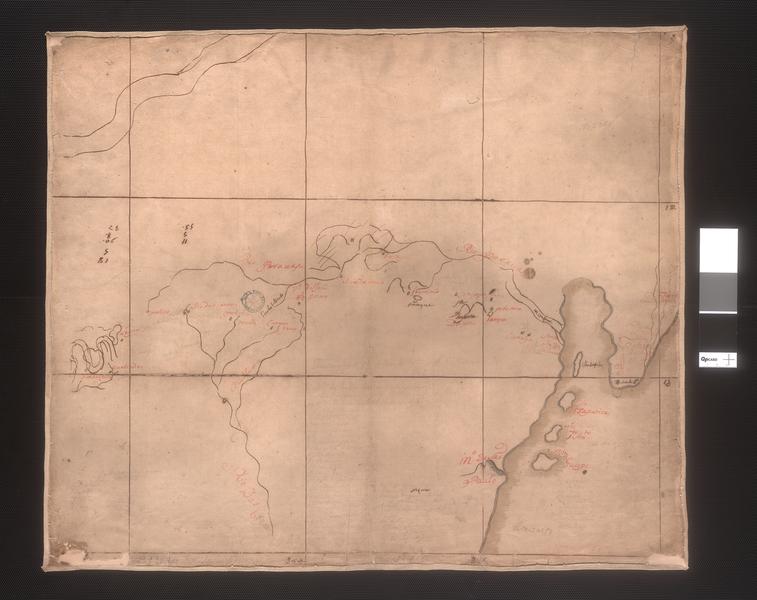
Русский: На данной рукописной карте начала XVIII века, составленной неизвестным картографом, изображены внутренние регионы бразильского штата Байя, который в то время оставался в значительной мере неисследованной территорией. Португальцы начали исследование данного региона еще в 1501 году, и вскоре он стал центром выращивания и переработки сахарного тростника. Сахар экспортировался из нескольких прибрежных городов штата Байя, крупнейшим из которых являлся Сальвадор.
Бразилия -- История -- Колониальный период, 1500-1822 гг.; Колониальные экспедиции; Реки Français : Cette carte manuscrite, réalisée au début du XVIIIe siècle par un cartographe inconnu, montre l'intérieur de l'État brésilien de Bahia, encore largement inexploré à l'époque. Les Portugais ont commencé à explorer cette région dès 1501, et l'ont rapidement transformée en centre pour la culture et la transformation du sucre. Le sucre était exporté à partir de plusieurs villes côtières de Bahia, dont la plus importante était Salvador.
Brésil -- Histoire -- Période Coloniale, 1500-1822; Expéditions coloniales; Rivières, fleuves et cours d'eau English: This early-18th century manuscript map by an unknown cartographer shows the interior of the Brazilian state of Bahia, still largely uncharted at that time. The Portuguese began to explore this region as early as 1501, and soon developed it into a center for growing and processing sugar. The sugar was exported from several of Bahia's coastal cities, the most important of which was Salvador.
Brazil -- History -- Colonial Period, 1500-1822; Colonial expeditions; Rivers 中文:这幅 18 世纪早期的手绘地图作者不详,描绘的是巴西的巴伊亚州内陆,当时大部分地区仍不为世人所知。 葡萄牙早在 1501 年便开始开发这片土地,不久将其开发成一个甘蔗种植与蔗糖加工中心。 巴伊亚的几个沿海城市均出口蔗糖,最重要的城市之一当属萨尔瓦多。
巴西-历史-殖民统治时期,1500 年-1822 年; 殖民远征; 河流 Português: Este mapa manuscrito do início de século XVIII, de um cartógrafo desconhecido, mostra o interior do estado brasileiro da Bahia, nessa época, ainda bastante inexplorado. Os portugueses começaram a explorar esta região já em 1501 e logo a transformaram em um centro de cultivo e processamento de açúcar. O açúcar era exportado de várias cidades costeiras da Bahia, a mais importante das quais era Salvador.
Brasil - História - Período Colonial, 1500-1822; Expedições coloniais; Rios العربية: تبين هذه الخريطة المخطوطة من أوائل القرن الثامن عشر المناطق الداخلية من ولاية باهيا في البرازيل، التي كان معظمها لا يزال لم يخط له خرائط بعد في ذلك الوقت. بدأ البرتغاليون استكشاف هذه المنطقة في وقت مبكر منذ عام 1501، وسرعان ما طوروها إلى مركز لزراعة ومعالجة السكر. وكان السكر يُصدر من عدد من مدن باهيا الساحلية، والتي كان من أهمها سلفادور.
البرازيل -- التاريخ -- الفترة الاستعمارية، 1500-1822; البعثات الاستكشافية الاستعمارية; الأنهار Español: Este mapa manuscrito de principios del siglo XVIII muestra el interior del estado brasileño de Bahía, al momento en que gran parte estaba todavía inexplorado. Los portugueses comenzaron a explorar la región en 1501 y pronto lo convirtieron en un centro de crecimiento y procesamiento del azúcar. El azúcar fue exportado desde varias de las ciudades costeras de Bahía, la más importante de las cuales fue Salvador.
Brasil - Historia - Período colonial, 1500-1822; Expediciones coloniales; Ríos |
| Date | between 1700 and 1799 |
| Medium |
Русский: Карты
Français : Cartes
English: Maps
中文:地图
Português: Mapas
العربية: خرائط
Español: Mapas |
| Dimensions |
English: 1 manuscript map : Ferrogálica drawing in ink and blood ; color ; 55.5 x 65.5 centimeters |
| Collection |
Русский: Национальная библиотека Бразилии
Français : Bibliothèque nationale du Brésil
English: National Library of Brazil
中文:巴西国家图书馆
Português: Biblioteca Nacional do Brasil
العربية: مكتبة البرازيل الوطنية
Español: Biblioteca Nacional de Brasil |
| Place of creation |
Русский: Бразилия
Français : Brésil
English: Brazil
中文:巴西
Português: Brasil
العربية: البرازيل
Español: Brasil |
| Notes | Original language title: Mapa da Bahia |
| References | http://hdl.loc.gov/loc.wdl/brrjbn.897 |
| Source/Photographer |
|
| Other versions | |
.png)
Licensing[edit]
|
This is a faithful photographic reproduction of a two-dimensional, public domain work of art. The work of art itself is in the public domain for the following reason:
The official position taken by the Wikimedia Foundation is that "faithful reproductions of two-dimensional public domain works of art are public domain".
This photographic reproduction is therefore also considered to be in the public domain in the United States. In other jurisdictions, re-use of this content may be restricted; see Reuse of PD-Art photographs for details. | ||||
File history
Click on a date/time to view the file as it appeared at that time.
| Date/Time | Thumbnail | Dimensions | User | Comment | |
|---|---|---|---|---|---|
| current | 01:31, 12 March 2014 | | 1,293 × 1,024 (2.16 MB) | Fæ (talk | contribs) | =={{int:filedesc}}== {{Artwork |artist = |author = |title ={{ru|1=Карта Байя}} {{fr|1=Carte de Bahia}} {{en|1=Map of Bahia}} {{zh|1=巴伊亚地图}} {{pt|1=Mapa da Bahia}} {{ar|1=خريطة باهيا}} {{es|1=Mapa de Bahía}} |description =... |
You cannot overwrite this file.
File usage on Commons
The following 2 pages use this file: