File:Map of Sealand with territorial waters-HE.svg
Jump to navigation
Jump to search

Size of this PNG preview of this SVG file: 587 × 600 pixels. Other resolutions: 235 × 240 pixels | 470 × 480 pixels | 752 × 768 pixels | 1,002 × 1,024 pixels | 2,005 × 2,048 pixels | 600 × 613 pixels.
Original file (SVG file, nominally 600 × 613 pixels, file size: 197 KB)
Captions
Captions
Add a one-line explanation of what this file represents
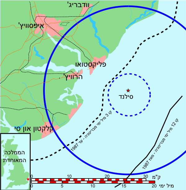
| Description | מפת סילנד |
| Date | |
| Source | own after File:Map of Sealand with territorial waters-hu.svg |
| Author | Ori~ |
Licensing[edit]

|
Permission is granted to copy, distribute and/or modify this document under the terms of the GNU Free Documentation License, Version 1.2 or any later version published by the Free Software Foundation; with no Invariant Sections, no Front-Cover Texts, and no Back-Cover Texts. A copy of the license is included in the section entitled GNU Free Documentation License. |
File history
Click on a date/time to view the file as it appeared at that time.
| Date/Time | Thumbnail | Dimensions | User | Comment | |
|---|---|---|---|---|---|
| current | 06:40, 22 July 2010 | | 600 × 613 (197 KB) | מתיא (talk | contribs) | A map of Sealand with the territorial waters before 1987 and after 1987. I hope that it will look good. Category:Maps Category:Maps of the United Kingdom |
| 12:43, 17 November 2009 |  | 600 × 613 (143 KB) | Ori~ (talk | contribs) | ed | |
| 12:39, 17 November 2009 |  | 600 × 613 (137 KB) | Ori~ (talk | contribs) | {{Information |Description=מפת סילנד |Source=own after File:Map of Sealand with territorial waters-hu.svg |Date=2009-11-17 |Author= Ori~ |Permission= |other_versions= }}Category:Sealand == {{int:license}} == {{GFDL|migration |
You cannot overwrite this file.
File usage on Commons
There are no pages that use this file.
File usage on other wikis
The following other wikis use this file:
- Usage on he.wikipedia.org