File:Map of the East Urals Radioactive Trace.png
Jump to navigation
Jump to search

Size of this preview: 800 × 591 pixels. Other resolutions: 320 × 236 pixels | 640 × 473 pixels | 1,024 × 756 pixels | 1,070 × 790 pixels.
Original file (1,070 × 790 pixels, file size: 1.38 MB, MIME type: image/png)
Captions
Captions
English version of File:Ostural-Spur.png
Summary[edit]
| Description |
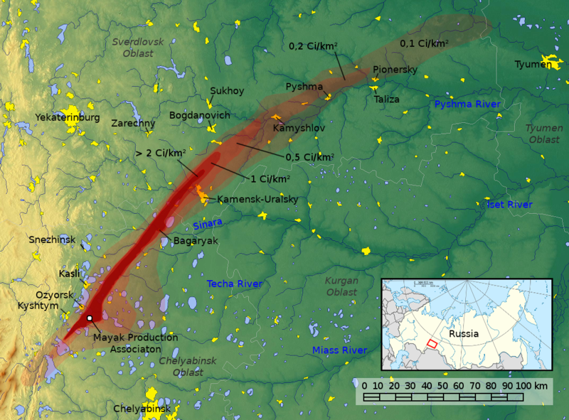
English: Map of the East Urals Radioactive Trace |
||
| Date | |||
| Source |
Own work Information from: |
||
| Author | Goran tek-en (following request by Kintetsubuffalo), Original Map: Jan Rieke, maps-for-free.com; Minimap: NordNordWest, Historicair, Bourrichon, Insider, Kneiphof | ||
| Permission (Reusing this file) |
This file is licensed under the Creative Commons Attribution-Share Alike 4.0 International license. Attribution: Goran tek-en, Jan Rieke, maps-for-free.com, NordNordWest, Historicair, Bourrichon, Insider, Kneiphof
|
||
| Other versions |
|

File history
Click on a date/time to view the file as it appeared at that time.
| Date/Time | Thumbnail | Dimensions | User | Comment | |
|---|---|---|---|---|---|
| current | 15:50, 6 February 2019 | | 1,070 × 790 (1.38 MB) | Goran tek-en (talk | contribs) | Requested by {{U|Kintetsubuffalo}} |
| 05:43, 4 February 2019 |  | 1,070 × 790 (1.39 MB) | Kintetsubuffalo (talk | contribs) | User created page with UploadWizard |
You cannot overwrite this file.
File usage on Commons
The following 3 pages use this file:
File usage on other wikis
The following other wikis use this file:
- Usage on de.wikivoyage.org
- Usage on en.wikipedia.org
- Usage on es.wikipedia.org
- Usage on fr.wikipedia.org
- Usage on he.wikipedia.org
- Usage on hi.wikipedia.org
- Usage on ja.wikipedia.org
- Usage on lv.wikipedia.org
- Usage on ms.wikipedia.org
- Usage on ru.wikipedia.org
- Usage on www.wikidata.org
- Usage on zh.wikipedia.org