File:Map of the Great Plains Road WDL11549.png

Original file (1,024 × 3,841 pixels, file size: 7.22 MB, MIME type: image/png)
Captions
Captions
Summary[edit]
| Author |
Русский: Дженкинс, Э. Э.
Français : Jenkins, E. E.
English: Jenkins, E. E.
中文:詹金斯,E•E
Português: Jenkins, E. E.
العربية: جينكينز، إي. إي.
Español: Jenkins, E. E. |
| Title |
Русский: Карта дороги "Грэйт-Плэйнс-Роуд".
Français : Carte de la Great Plains Road (route des Grandes Plaines)
English: Map of the Great Plains Road
中文:大平原公路地图
Português: Mapa da Great Plains Road (Estrada das Grandes Planícies)
العربية: خريطة طريق السهول العظمى
Español: Mapa de la ruta de las Grandes Llanuras |
| Description |
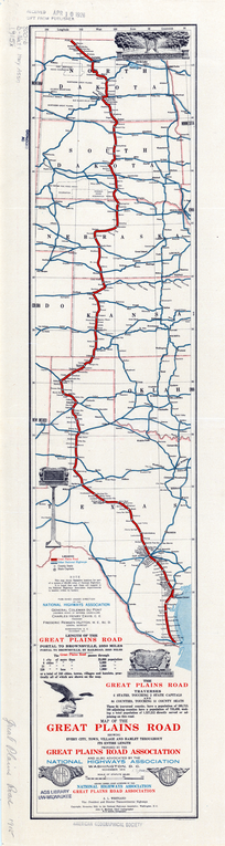
Русский: В 1911 г. в США была основана Национальная ассоциация автомагистралей, призванная оказывать содействие развитию национальной сети качественных автомобильных дорог. Под лозунгом "Хорошие дороги всем!" Национальная ассоциация автомагистралей выступала за строительство и постоянное обслуживание федеральным правительством системы автомагистралей протяженностью 50 000 миль (около 80 500 км). На этой карте, выпущенной ассоциацией в 1915 г., показана дорога "Грэйт-Плэйнс-Роуд", строительство которой было предложено ассоциацией "Грэйт-Плэйнс-Роуд" и одобрено Национальной ассоциацией автомагистралей. Запланированный маршрут протяженностью 2350 миль (3782 км) пролегает от деревни Портал, штат Северная Дакота, на границе между США и Канадой, до Браунсвилла, штат Техас, на границе с Мексикой. В примечаниях и таблице в нижней части указано количество штатов, округов и городов различных размеров, через которые пройдет дорога, а также предполагаемая численность населения, которое получит возможность пользоваться ею. Помимо выпуска брошюр и рекламных проспектов, убеждавших граждан в необходимости создания национальной системы дорог, ассоциация издавала большое количество карт. Картографические работы выполнялись коллективом примерно из 40 человек в бюро в Саут-Ярмуте, штат Массачусетс, принадлежавшем президенту и соучредителю ассоциации Чарльзу Генри Дэвису (1865–1951 гг.). Дэвис полагал, что эти карты принесут пользу национальной комиссии по автомагистралям, на создание которой он надеялся, и помогут штатам объединить свои дороги в единую национальную систему. Конгресс США так и не принял план, предложенный ассоциацией, однако деятельность этой организации и выпущенные ею карты способствовали делу создания национальной дорожной сети.
Планирование автомагистралей; Дороги Français : La NHA (Association nationale pour les grandes routes) fut établie en 1911 pour promouvoir le développement d'un réseau routier national amélioré aux États-Unis. Sous le slogan « De bonnes routes pour tout le monde ! », la NHA militait pour la construction et l'entretien permanent par le gouvernement fédéral d'un système de grandes routes de près de 80 500 kilomètres (50 000 miles). Cette carte, qu'elle émit en 1915, montre le tracé de la Great Plains Road (route des Grandes Plaines), proposé par l'association du même nom et soutenu par la NHA. La route devait s'étendre de la frontière entre les États-Unis et le Canada, à Portal, dans le Dakota du Nord, à Nogales, en Arizona, sur la frontière entre le Mexique et les États-Unis, soit une distance de 3 782 kilomètres (2 350 miles). Les notes et le tableau au bas de la carte indiquent le nombre d'États, de comtés et de villes, classées par population, que la route devait traverser, ainsi que le nombre d'habitants qu'elle devait desservir. Outre la diffusion de brochures et de prospectus visant à convaincre les citoyens du besoin d'un réseau routier national, la NHA produisit un grand nombre de cartes. Le travail de cartographie était effectué dans un bureau de South Yarmouth, dans le Massachusetts, où près de 40 personnes étaient employées sur la propriété de Charles Henry Davis (1865–1951), président et cofondateur de la NHA. Davis pensait non seulement que ces cartes seraient utiles à la commission des grandes routes nationales, dont il espérait la création, mais qu'elles aideraient également les États à intégrer leurs routes dans un système national. Bien que le Congrès n'adoptât jamais le plan proposé par la NHA, cette organisation et ses cartes servirent la cause d'un réseau routier national.
Planification des routes; Routes English: The National Highways Association (NHA) was established in 1911 to promote the development of an improved national road network in the United States. Under the slogan “Good roads for everyone!” the NHA advocated the building and permanent maintenance by the federal government of a system of 50,000 miles (some 80,500 kilometers) of highways. This map, issued by the NHA in 1915, shows the Great Plains Road, proposed by the Great Plains Road Association and endorsed by the NHA. The projected route runs from the U.S.–Canada border in Portal, North Dakota, to Brownsville, Texas, on the U.S.–Mexico border, a distance of 2,350 miles (3,782 kilometers). The notes and table at the bottom indicate the numbers of states, counties, and cities of different sizes traversed by the route and the population expected to be served. Besides issuing brochures and circulars aimed at convincing citizens of the need for a national road system, the NHA was a prolific producer of maps. Cartographic work was done at an office in South Yarmouth, Massachusetts, where approximately 40 people were employed on the property of Charles Henry Davis (1865–1951), president and cofounder of the NHA. Davis believed that these maps would be helpful to a national highways commission that he hoped would be established and that they would assist the states in integrating their roads into a national system. Congress never embraced the plan put forward by the NHA, but the organization and its maps helped to promote the cause of a national road network.
Highway planning; Roads 中文:国家公路协会 (NHA) 成立于 1911 年,旨在促进美国国家公路网的完善。NHA 以“建好路,为人人!”为口号,主张联邦政府修建 50000 英里(约 80500 千米)的公路系统,并永久维护保养。这幅地图由 NHA 发行于 1915 年,展示了大平原公路协会提议、NHA 支持修建的 Great Plains Road(大平原公路)。预建路线自北达科他州波特尔美加边境延伸至德克萨斯州布朗斯维尔美墨边境,全长 2350 英里(3782 千米)。地图底部的注解和表格指出了路线经过的大小各异的州、郡、市数量以及预计受惠人口数量。NHA 发布了很多小册子和通报,以说服公民关于国家公路体系的重要;除此之外,还制作了大量地图。制图工作办公室在马萨诸塞州南雅茅斯,属于 NHA 协会会长及创始人之一的查尔斯•亨利•戴维斯(Charles Henry Davis,1865–1951 年)所有,约 40 名员工在这里工作。戴维斯希望设立国家公路委员会,以帮助各州将其公路融入国家体系,他相信这些地图对委员会有所帮助。虽然国会始终没有采纳 NHA 提出的计划,但协会和所绘的地图还是促进了国家公路网络的建设。
公路规划; 公路 Português: A National Highways Association - NHA (Associação Nacional de Rodovias) foi criada em 1911 para promover o desenvolvimento de uma malha rodoviária nacional aperfeiçoada nos Estados Unidos. Com o slogan “Boas estradas para todo mundo!”, a NHA defendia a contrução e a manutenção permanente, por parte do governo federal, de um sistema de 50.000 milhas (em torno de 80.500 quilômetros) de rodovias. Este mapa, publicado pela NHA em 1915, mostra a Great Plains Road (Estrada das Grandes Planícies), proposta pela Great Plains Road Association e apoiada pela NHA. A rota projetada vai da fronteira dos EUA com o Canadá, em Portal, Dakota do Norte, até Brownsville, Texas, na fronteira dos EUA com o México, com uma distância de 2.350 milhas (3.728 quilômetros). As notas e a tabela na parte inferior indicam o número de estados, condados e cidades de diferentes tamanhos atravessadas pela rota e a população que se esperava atender. Além de emitir brochuras e panfletos visando convencer os cidadãos da necessidade de um sistema rodoviário nacional, a NHA foi uma prolífica produtora de mapas. O trabalho cartográfico era realizado no escritório de South Yarmouth, Massachusetts, onde aproximadamente 40 pessoas eram empregadas na propriedade de Charles Henry Davis (1865 a 1951), presidente e cofundador da NHA. Davis acreditava que estes mapas seriam úteis para uma comissão rodoviária nacional, que ele esperava ser estabelecida, e que eles ajudariam os estados a integrar suas estradas com o sistema nacional. O Congresso nunca acatou o plano proposto pela NHA, mas a organização e seus mapas ajudaram a promover a causa de um sistema rodoviário nacional.
Planejamento rodoviário; Estradas العربية: أُسست الهيئة الوطنية للطرق السريعة (NHA) عام 1911 بهدف الترويج لفكرة إنشاء شبكة طرق وطنية محسنة في الولايات المتحدة الأمريكية. وتحت شعار "طرق جيدة للجميع!" دعت الهيئةُ الحكومةَ الفيدرالية إلى تبني فكرة بناء نظام طرق سريعة يبلغ 50.000 ميل (أي حوالي 80.500 كيلو متر) وصيانة تلك الشبكة بشكلٍ دائم. توضح هذه الخريطة التي أصدرتها الهيئة الوطنية للطرق السريعة عام 1915، طريق السهول الكبرى، الذي اقترحته هيئة طريق السهول العظمى وتبنته الهيئة الوطنية. يمتد الطريق المُقترح من حدود الولايات المتحدة وكندا عند بورتَل، شمال داكوتا، إلى براونزفيل، تكساس، على حدود الولايات المتحدة والمكسيك، أي مسافة 2.350 ميلاً (3.782 كيلو متراً). توضح الملاحظات والجدول بالأسفل عدد الولايات والمحليات والمدن مختلفة الأحجام التي سيمر عبرها الطريق والسكان المتوقع خدمتهم. إضافة إلى طباعة النشرات والكتيبات التي تهدف إلى إقناع المواطنين بالحاجة إلى إنشاء نظام طرق وطني، فقد أصدرت الهيئة الوطنية للطرق السريعة الكثير من الخرائط. أجريت عملية رسم الخرائط في مكتب بساوث يارموث، ماساتشوستس، على أرضٍ كانت لتشارلز هنري ديفيس (1865-1951)، حيث عُيِّن حوالي 40 شخصاً لذلك الغرض. كان ديفيس يعتقد أن هذه الخرائط قد تُمثل أهمية للجنة الطرق السريعة الوطنية التي كان يأمل أن يتم تأسيسها وأنها ستساعد الولايات على دمج طرقها في نظام وطني. إلا أن الكونغرس لم يتبن أبداً الخطة التي عرضتها الهيئة، ولكن الهيئة والخرائط التي أصدرتها ساعدت في الترويج لقضية إنشاء شبكة طرق وطنية.
تخطيط الطرق السريعة; الطرق Español: La Asociación Nacional de Carreteras (NHA, por sus siglas en inglés) se estableció en 1911 para fomentar el desarrollo de una red nacional mejorada de caminos en los Estados Unidos. Bajo el lema «¡Buenos caminos para todos!», la NHA abogaba por que el gobierno federal construyera y mantuviera de forma permanente un sistema de 50 000 millas (unos 80 500 kilómetros) de carreteras. Este mapa, publicado por la NHA en 1915, muestra la ruta de las Grandes Llanuras, propuesta por la Asociación de la Ruta de las Grandes Llanuras y aprobada por la NHA. La ruta proyectada comenzaría en la frontera entre los Estados Unidos y Canadá, en Portal, Dakota del Norte, y terminaría en Brownsville, Texas, en la frontera entre los Estados Unidos y México: cubriría una distancia de 2350 millas (3782 kilómetros). Las notas y el cuadro en la parte inferior indican la cantidad de ciudades, condados y estados de diferentes tamaños que atravesaría la ruta, así como la población estimada a la que serviría. Además de emitir folletos y circulares destinados a convencer a los ciudadanos de la necesidad de un sistema nacional de caminos, la NHA fue una prolífica productora de mapas. El trabajo cartográfico se realizaba en South Yarmouth, Massachusetts, en una oficina de propiedad de Charles Henry Davis (1865-1951) —presidente y cofundador de la NHA— en la que había alrededor de 40 personas empleadas. Davis creía que estos mapas serían útiles para una comisión nacional de carreteras, que esperaba que se estableciera, y ayudarían los estados a integrar sus caminos en un sistema nacional. El Congreso nunca adoptó el plan presentado por la NHA, pero la organización y sus mapas ayudaron a promover la causa de una red nacional de caminos.
Planificación de carreteras; Caminos |
| Date | November 1915 |
| Medium |
Русский: Карты
Français : Cartes
English: Maps
中文:地图
Português: Mapas
العربية: خرائط
Español: Mapas |
| Dimensions |
English: 1 map : color ; 67 x 14 centimeters |
| Collection |
Русский: Библиотеки университета Висконсин–Милуоки
Français : Bibliothèques de l’Université du Wisconsin-Milwaukee
English: University of Wisconsin-Milwaukee Libraries
中文:威斯康星大学密尔沃基分校图书馆
Português: Bibliotecas da Universidade de Wisconsin-Milwaukee
العربية: مكتبات جامعة وِسْكَنْسِنْ بِمِلْوَوْكِى
Español: Bibliotecas de la Universidad de Wisconsin - Milwaukee |
| Current location |
Русский: Цифровая коллекция карт библиотеки Американского географического общества
Français : Collection de cartes numériques de la bibliothèque de l'American Geographical Society
English: American Geographical Society Library Digital Map Collection
中文:美国地理学会图书馆数字地图集
Português: Coleção de Mapas Digitais da Biblioteca da Sociedade Geográfica Americana
العربية: مجموعة الخرائط الرقمية لمكتبة الجمعية الجغرافية الأمريكية
Español: Colección de mapas digitales de la Biblioteca de la Sociedad Geográfica Estadounidense |
| Place of creation |
Русский: Канзас
Français : Kansas
English: Kansas
中文:堪萨斯州
Português: Kansas
العربية: كنساس
Español: Kansas |
| Notes |
Original language title: Map of the Great Plains Road: Showing Every City, Town, Village and Hamlet Throughout its Entire Length Русский: Масштаб 1:5 000 000
Français : Échelle : 1:5 000 000
English: Scale 1:5,000,000
中文:比例尺:1:5,000,000
Português: Escala 1:5.000.000
العربية: مقياس الرسم 5,000,000:1
Español: Escala 1:5 000 000 |
| References | http://hdl.loc.gov/loc.wdl/wmuw.11549 |
| Source/Photographer |
|
Licensing[edit]
|
This is a faithful photographic reproduction of a two-dimensional, public domain work of art. The work of art itself is in the public domain for the following reason:
The official position taken by the Wikimedia Foundation is that "faithful reproductions of two-dimensional public domain works of art are public domain".
This photographic reproduction is therefore also considered to be in the public domain in the United States. In other jurisdictions, re-use of this content may be restricted; see Reuse of PD-Art photographs for details. | ||||
File history
Click on a date/time to view the file as it appeared at that time.
| Date/Time | Thumbnail | Dimensions | User | Comment | |
|---|---|---|---|---|---|
| current | 22:31, 10 March 2014 | 1,024 × 3,841 (7.22 MB) | Fæ (talk | contribs) | =={{int:filedesc}}== {{Artwork |artist = |author ={{ru|1=Дженкинс, Э. Э.}} {{fr|1=Jenkins, E. E.}} {{en|1=Jenkins, E. E.}} {{zh|1=詹金斯,E•E}} {{pt|1=Jenkins, E. E.}} {{ar|1=جينكينز، إي. إي.}} {{es|1=Jenkins, E. E.}} |t... |
You cannot overwrite this file.
File usage on Commons
The following page uses this file: