File:Marinko Oluić Biografija.pdf

Original file (1,239 × 1,622 pixels, file size: 2.37 MB, MIME type: application/pdf, 3 pages)
Captions
Captions
Summary[edit]
| Description |
Hrvatski: Dr. sc. Marinko Oluić rođen je 1935. godine u Bilišanima kraj Obrovca, Hrvatska. Srednju školu završio je u Beogradu, a studij geologije na Prirodoslovno-matematičkom fakultetu Sveučilišta u Zagrebu. Na Bergakademie u Freibergu ( Njemačka) specijalizirao se u primjeni fotogrametrije i fotointerpretacije u geologiji. Doktorirao je 1973. na Humboldtovu Sveučilištu u Berlinu i stekao akademski naziv Doktor rerum naturalium (Dr. prirodnih nauka).
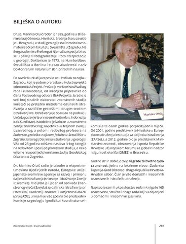
Po završetku studija zaposlio se u Institutu za naftu u Zagrebu, koji je potom prerastao u Industroprojekt, odnosno INA-Projekt. Prošao je sve faze istraživačkog rada i rukovođenja, od inženjera pripravnika do člana Poslovodnog odbora INA-Projekta. Izradio je veći broj stručnih elaborata i znanstvenih studija koristeći se pretežno metodama daljinskih istraživanja u različitim geološkim i drugim srodnim istraživanjima. Istraživanja je obavljao na području bivše Jugoslavije te u inozemstvu (Jordan, Indonezija, Irak-Kurdistan). Istodobno je izabran u znanstveno zvanje znanstvenog savjetnika- u trajnom zvanju, izvanrednog, a potom i redovitog profesora na Rudarsko-geološko-naftnom fakultetu Sveučilišta u Zagrebu za kolegij Daljinska istraživanja u geologiji. Više od 25 godina održava nastavu iz tog kolegija na redovitom i poslijediplomskom studiju, a neko vrijeme i na poslijediplomskom studiju Geodetskog fakulteta u Zagrebu. Dr. Marinko Oluić radio je također u ekspertnim timovima Ujedinjenih naroda, Europske unije i Japanske svemirske agencije za razvoj i primjenu daljinskih istraživanja (snimanje i istraživanje Zemlje iz svemira). Inicijator je i jedan od osnivača Znanstvenog vijeća (Savjeta) za daljinska istraživanja pri Hrvatskoj akademiji znanosti i umjetnosti-HAZU (prije JAZU), u kojem je više godina bio predsjednik Komisije za geologiju i geofiziku i koordinator svih komisija te osam godina potpredsjednik Vijeća. Od 2001. godine predstavnik je Hrvatske u Europskom udruženju institucija za daljinska istraživanja (EARSeL), a 2012. godine bio je predstavnik Ministarstva znanosti, obrazovanja i sporta Republike Hrvatske u Europskom forumu za globalni nadzor i sigurnost okoliša (GMES) u Brusselsu. Godine 2017. dobio je dvije nagrade za životno djelo za znanost. Jednu na lokalnom nivou –Zadarska županija-Grad Obrovac i druga-Republika Hrvatska-Hrvatski sabor. Član je više domaćih i inozemnih znanstvenih i stručnih udruženja. Napisao je sam ili u koautorstvu sedam knjiga te 165 znanstvena, stručna i druga rada koji su objavljeni u domaćim i inozemnim glasilima.English: Education
1956. Geological Technical School in Belgrade, Serbia - Geologic technician. 1961. Faculty of Sciences – Department of Geology, University of Zagreb, Croatia (Graduated engineer of geology). 1965. Bergakademie, Freiberg, Germany: Specialization 6 months - Photogrammetry and photointerpretation in Geology. 1973. Humboldt University in Berlin, Germany: Doctoral Thesis: “Vergleichende photogrammetrische Erfassung von geologisch-geotektonischen Gegebenheiten in morphologisch unterschedlichen Gebieten (Dr. rer. nat.). Employment 1963. Petroleum Institut, Zagreb (1965. Institute renamed into Industroproject). 1983. Associate with INA-Engineering into INA-Project. Co, 1992. GEO-SAT Ltd. 1965. - 1983. Head of Department for Remote sensing and mineral exploration. Leader of numerous projects, predominantly of Structural–geomorphological exploration, Petroleum-geological exploration, Exploration of various mineral resources (Gold, Copper, Coal, Bauxite etc.), Seismotectonical exploration (Earthquakes) etc., in former Yugoslavia and abroad (Jordan, Indonesia, Kurdistan-Iraq). 1983. - 1985. Business Board Adviser in INA Project for Geo-sciences and Development. 1985. - 1988. Member of the Business Board in INA-Project (with about 1600 employees). 1992. - GEO-SAT Ltd. Company for Exploration and Development, Zagreb. (company Founder). 2010. - 2012 EU Project OBSERVE – Strengthening and development of Earth Observation activities for the environment in the Balkan area – European Commission – FP7: 15 institutions from 13 different countries (Aristotle University of Thessaloniki, Greece). 2013. - 2014. Project leader: Application of SAR Imagery for mapping of natural oil slicks in middle part of Adriatic Sea. Academic Work Experience Teaching experience in graduate and post-graduate studies of Geology University of Zagreb. 1978. Faculty of Mining, Geology and Petroleum Engineering University of Zagreb: Senior scientific assistant. 1984. Faculty of Mining, Geology and Petroleum Engineering Zagreb University: Scientific Adviser in Natural Scientific Area. 1975. Faculty of Mining, Geology and Petroleum Engineering University of Zagreb: Associate Professor. 1989. Faculty of Mining, Geology and Petroleum Engineering: Full Professor. Bibliography Books 7 Books. The most important are: 1983: Remote Sensing in Geology In: Remote Sensing in Earth Sciences (eds.: V. Donassy, M. Oluić and Z. Tomašegović), Yugoslav Acad. Sci. Arts, Zagreb, 141-268 pp. 2001. Earth Imaging and Exploration from Space – Satellites - Sensors - Applications. Croatian Acad. Sci. Arts and GEO-SAT, Zagreb, 516 pp. 2003. GOLD from origin to use. Prosvjeta, Zagreb, 160 pp. 2015. EARTHQUAKES – Causes and Consequences with Regards to Croatia and Neighboring Regions. Prosvjeta and GEO-SAT, Zagreb, 346 pp. Other publications Author/Co-author of about 160 technical and scientific articles published in domestic and foreign journals. Attended 40 International symposia and congresses abroad, and 24 in Croatia. Organizer of several scientific events (e. g. 24th Symposium of European Association of Remote Sensing Laboratories – EARSeL: New Strategies for European Remote Sensing, Dubrovnik, Croatia, 25-27 May 2004, and Edited Proceedings (768 pp), 1st International Conference on Remote Sensing Techniques in Disaster Management and Emergency Response in the Mediterranean Region. Zadar, Croatia, 22-24 September 2008 and Edited Proceedings (420 pp). Internationally recognized as one of the leading expert in the field of remote sensing in geosciences (Geology, Oil and gas exploration, Mineral exploitation, Natural hazards, Ecology, etc.). Member of the several domestic and international professional associations. He was also Project manager and principal investigator of several domestic and international projects. |
| Date | |
| Source | Own work |
| Author | Toncic~hrwiki |
Licensing[edit]
- You are free:
- to share – to copy, distribute and transmit the work
- to remix – to adapt the work
- Under the following conditions:
- attribution – You must give appropriate credit, provide a link to the license, and indicate if changes were made. You may do so in any reasonable manner, but not in any way that suggests the licensor endorses you or your use.
- share alike – If you remix, transform, or build upon the material, you must distribute your contributions under the same or compatible license as the original.
File history
Click on a date/time to view the file as it appeared at that time.
| Date/Time | Thumbnail | Dimensions | User | Comment | |
|---|---|---|---|---|---|
| current | 11:16, 16 December 2022 |  | 1,239 × 1,622, 3 pages (2.37 MB) | Toncic~hrwiki (talk | contribs) | Uploaded own work with UploadWizard |
You cannot overwrite this file.
File usage on Commons
There are no pages that use this file.