File:Mauna Loa hazard map.gif
Jump to navigation
Jump to search
No higher resolution available.
Mauna_Loa_hazard_map.gif (363 × 368 pixels, file size: 33 KB, MIME type: image/gif)
Captions
Captions
Add a one-line explanation of what this file represents
Summary[edit]
| Description |
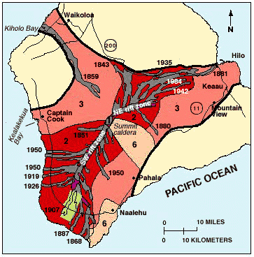
English: Hazard mapping of Mauna Loa volcano. |
| Date | Probably 1984, the year the study was concluded. |
| Source | http://pubs.usgs.gov/gip/hazards/mauna-loa.html |
| Author | USGS |
Licensing[edit]
This image is in the public domain in the United States because it only contains materials that originally came from the United States Geological Survey, an agency of the United States Department of the Interior. For more information, see the official USGS copyright policy.
|
File history
Click on a date/time to view the file as it appeared at that time.
| Date/Time | Thumbnail | Dimensions | User | Comment | |
|---|---|---|---|---|---|
| current | 19:09, 25 January 2013 | | 363 × 368 (33 KB) | Resident Mario (talk | contribs) | {{Information |Description ={{en|1=Hazard mapping of Mauna Loa volcano.}} |Source =http://pubs.usgs.gov/gip/hazards/mauna-loa.html |Author =USGS |Date =Probably 1984, the year the study was concluded. |Per... |
You cannot overwrite this file.
File usage on Commons
There are no pages that use this file.