File:Mauritania (MODIS 2021-12-16).jpg
Jump to navigation
Jump to search

Size of this preview: 747 × 599 pixels. Other resolutions: 299 × 240 pixels | 598 × 480 pixels | 957 × 768 pixels | 1,277 × 1,024 pixels | 2,088 × 1,675 pixels.
Original file (2,088 × 1,675 pixels, file size: 885 KB, MIME type: image/jpeg)
Captions
Captions
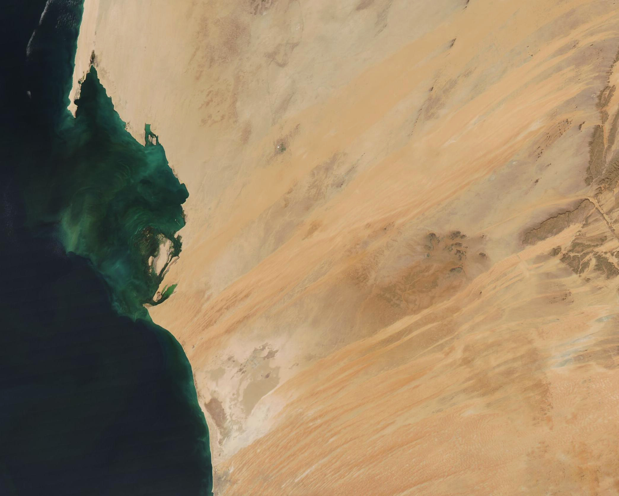
This stunning true-color image of western Mauritania was captured by the Moderate Resolution Imaging Spectroradiometer (MODIS) on board NASA’s Terra satellite on December 15.
Summary[edit]
.jpg&action=edit§ion=1)
| Description |
English: This stunning true-color image of western Mauritania was captured by the Moderate Resolution Imaging Spectroradiometer (MODIS) on board NASA’s Terra satellite on December 15. The clear skies of the sunny spring day permitted a gorgeous view of the country’s orange sands, rugged rock outcroppings, and offshore color.
Mauritania sits on the northwestern coast of Africa, where the arid Sahara Desert meets the semi-arid Sahel. About three-fourths of the country sits solidly within the Sahara Desert, and is comprised of flat plains, a broken plateau made up of mesas (flat-topped hills), and orange-colored sand dunes. The prevailing wind in this part Mauritania blow from the northeast, lending to the sweeping, richly-colored, orange streaks of sand that stretch from northeast to southwest in this image. The color off the coast is created by a combination of phytoplankton and sediment. Phytoplankton are microscopic plant-like organisms that contain chlorophyll and thrive in nutrient-rich water. The waters off of Mauritania typically are rich in diatoms, one of the most common type of phytoplankton found in oceans. They often reproduce explosively, creating a large “bloom” that can be seen from space, after strong storms mix the oceans and bring nutrients up from the seafloor. The waters off of Mauritania are constantly in motion, thanks to an upwelling caused by near-constant trade winds that roil the surface, causing it to be displaced as it is blown away from the African coast. As this occurs, the cold and nutrient-rich waters from deep below the surface are pulled upward to the surface—carrying nutrient-rich waters that feed a phytoplankton bloom. Because the upwelling in this region is near-constant, phytoplankton feast year-round in this location, and are frequently seen in satellite images. |
||
| Date | Taken on 15 December 2021 | ||
| Source |
|
||
| Author | MODIS Land Rapid Response Team, NASA GSFC |
| This media is a product of the Aqua mission Credit and attribution belongs to the mission team, if not already specified in the "author" row |
Licensing[edit]
.jpg&action=edit§ion=2)
| This file is in the public domain in the United States because it was solely created by NASA. NASA copyright policy states that "NASA material is not protected by copyright unless noted". (See Template:PD-USGov, NASA copyright policy page or JPL Image Use Policy.) | ||
 |
Warnings:
|
File history
Click on a date/time to view the file as it appeared at that time.
| Date/Time | Thumbnail | Dimensions | User | Comment | |
|---|---|---|---|---|---|
| current | 00:21, 17 January 2024 | | 2,088 × 1,675 (885 KB) | OptimusPrimeBot (talk | contribs) | #Spacemedia - Upload of http://modis.gsfc.nasa.gov/gallery/images/image12162021_250m.jpg via Commons:Spacemedia |
You cannot overwrite this file.
File usage on Commons
There are no pages that use this file.
.jpg&oldid=842555960)