File:Melbourne Metro Rail Tunnel route map.svg
Jump to navigation
Jump to search

Size of this PNG preview of this SVG file: 800 × 420 pixels. Other resolutions: 320 × 168 pixels | 640 × 336 pixels | 1,024 × 538 pixels | 1,280 × 672 pixels | 2,560 × 1,344 pixels | 1,600 × 840 pixels.
Original file (SVG file, nominally 1,600 × 840 pixels, file size: 29 KB)
Captions
Captions
Add a one-line explanation of what this file represents
Summary[edit]
| Description |
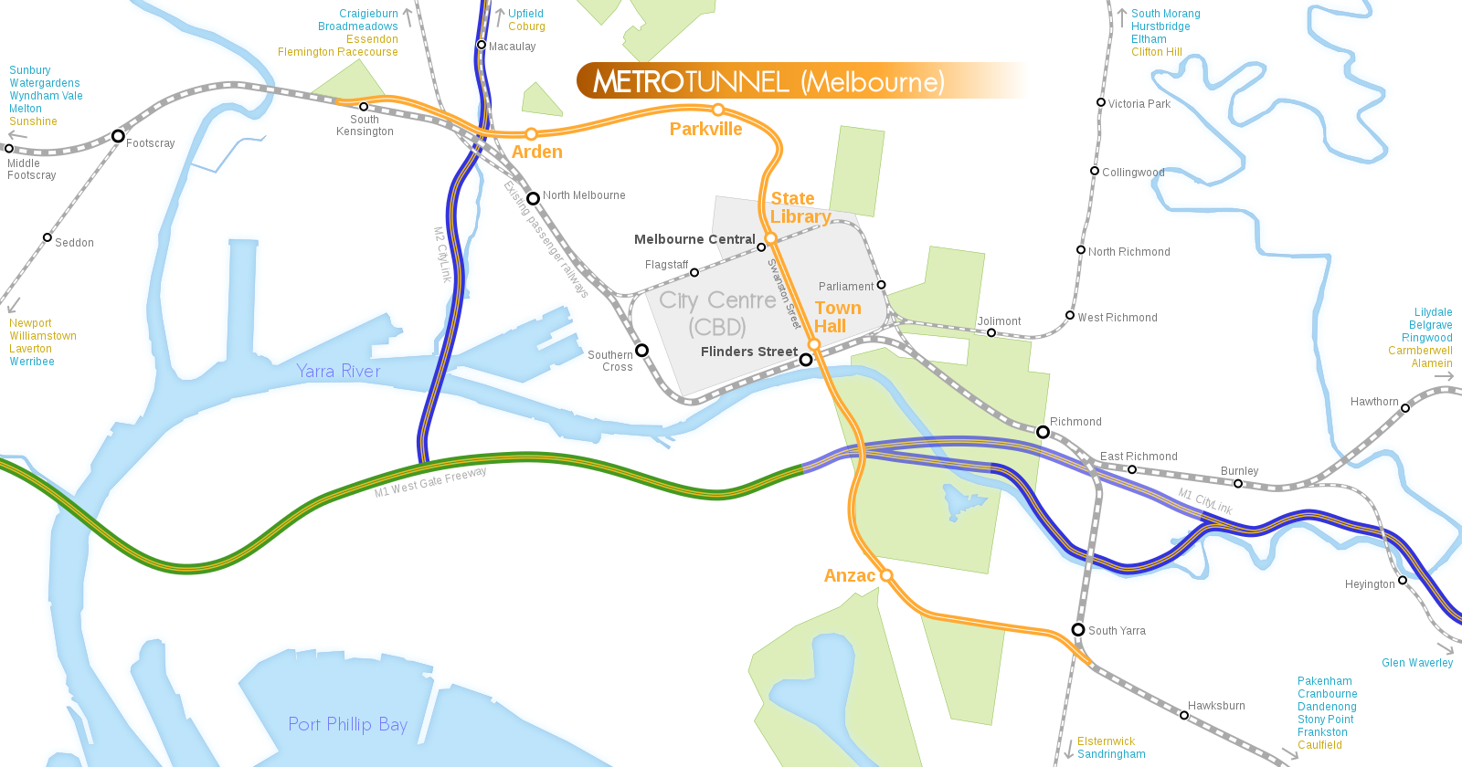
English: Geographical map depicting Melbourne Metro Rail Project (Metro Tunnel). |
| Date | (upload date) |
| Source | Own work. Referenced OpenStreetMap and diagram from the official site of Metro Tunnel, but all graphical elements in this image were done from scratch. |
| Author | Sameboat |
| SVG development |
Licensing[edit]
I, the copyright holder of this work, hereby publish it under the following licenses:
This file is licensed under the Creative Commons Attribution-Share Alike 4.0 International license.
- You are free:
- to share – to copy, distribute and transmit the work
- to remix – to adapt the work
- Under the following conditions:
- attribution – You must give appropriate credit, provide a link to the license, and indicate if changes were made. You may do so in any reasonable manner, but not in any way that suggests the licensor endorses you or your use.
- share alike – If you remix, transform, or build upon the material, you must distribute your contributions under the same or compatible license as the original.

|
Permission is granted to copy, distribute and/or modify this document under the terms of the GNU Free Documentation License, Version 1.2 or any later version published by the Free Software Foundation; with no Invariant Sections, no Front-Cover Texts, and no Back-Cover Texts. A copy of the license is included in the section entitled GNU Free Documentation License. |
You may select the license of your choice.
File history
Click on a date/time to view the file as it appeared at that time.
| Date/Time | Thumbnail | Dimensions | User | Comment | |
|---|---|---|---|---|---|
| current | 08:05, 26 January 2020 | | 1,600 × 840 (29 KB) | Sameboat (talk | contribs) | West Melbourne > North Melbourne |
| 08:02, 26 January 2020 |  | 1,600 × 840 (29 KB) | Sameboat (talk | contribs) | North Melbourne -> Arden | |
| 12:58, 7 June 2019 |  | 1,600 × 840 (29 KB) | Numbermaniac (talk | contribs) | Watergardens was misspelled as "Watergradens" | |
| 04:25, 7 June 2019 |  | 1,600 × 840 (29 KB) | Numbermaniac (talk | contribs) | "Cranbourne" was misspelled as "Cranhourne" | |
| 14:55, 15 July 2018 |  | 1,600 × 840 (29 KB) | Sameboat (talk | contribs) | doctype | |
| 04:47, 29 November 2017 |  | 1,600 × 840 (29 KB) | Sameboat (talk | contribs) | "Library" | |
| 04:17, 29 November 2017 |  | 1,600 × 840 (29 KB) | Pizza1016 (talk | contribs) | Fixed accidentally duplicated id | |
| 04:13, 29 November 2017 |  | 1,600 × 840 (29 KB) | Pizza1016 (talk | contribs) | Final names announced: Arden => North Melbourne Parkville => Parkville CBD North => State Library CBD South => Town Hall Domain => Anzac Renamed: North Melbourne => West Melbourne | |
| 06:45, 22 November 2016 |  | 1,600 × 840 (28 KB) | Sameboat (talk | contribs) | minor changes which only matter when you open the SVG in browser and select the text or mouse-hover over special object. | |
| 08:47, 21 November 2016 |  | 1,600 × 840 (28 KB) | Pizza1016 (talk | contribs) | Proofread + more major stations outside view |
You cannot overwrite this file.
File usage on Commons
The following 25 pages use this file:
- User:Chumwa/OgreBot/Potential transport maps/2016 November 11-20
- User:Chumwa/OgreBot/Potential transport maps/2016 November 21-30
- User:Chumwa/OgreBot/Potential transport maps/2017 November 21-30
- User:Chumwa/OgreBot/Potential transport maps/2018 July 11-20
- User:Chumwa/OgreBot/Potential transport maps/2019 June 1-10
- User:Chumwa/OgreBot/Potential transport maps/2020 January 21-31
- User:Chumwa/OgreBot/Public transport information/2016 November 11-20
- User:Chumwa/OgreBot/Public transport information/2016 November 21-30
- User:Chumwa/OgreBot/Public transport information/2017 November 21-30
- User:Chumwa/OgreBot/Public transport information/2018 July 11-20
- User:Chumwa/OgreBot/Public transport information/2019 June 1-10
- User:Chumwa/OgreBot/Public transport information/2020 January 21-31
- User:Chumwa/OgreBot/Transport Maps/2016 November 11-20
- User:Chumwa/OgreBot/Transport Maps/2016 November 21-30
- User:Chumwa/OgreBot/Transport Maps/2017 November 21-30
- User:Chumwa/OgreBot/Transport Maps/2018 July 11-20
- User:Chumwa/OgreBot/Transport Maps/2019 June 1-10
- User:Chumwa/OgreBot/Transport Maps/2020 January 21-31
- User:Chumwa/OgreBot/Travel and communication maps/2016 November 11-20
- User:Chumwa/OgreBot/Travel and communication maps/2016 November 21-30
- User:Chumwa/OgreBot/Travel and communication maps/2017 November 21-30
- User:Chumwa/OgreBot/Travel and communication maps/2018 July 11-20
- User:Chumwa/OgreBot/Travel and communication maps/2019 June 1-10
- User:Sameboat
- Commons:Graphic Lab/Map workshop/Archive/2016
File usage on other wikis
The following other wikis use this file:
- Usage on en.wikinews.org
- Usage on www.wikidata.org
- Usage on zh.wikipedia.org