File:Metropolitan and Micropolitan Statistical Areas of the United States and Puerto Rico.gif
Jump to navigation
Jump to search

Size of this preview: 800 × 514 pixels. Other resolutions: 320 × 206 pixels | 640 × 411 pixels | 1,024 × 658 pixels | 1,280 × 823 pixels | 2,560 × 1,645 pixels | 4,000 × 2,571 pixels.
Original file (4,000 × 2,571 pixels, file size: 1.06 MB, MIME type: image/gif)
Captions
Captions
Add a one-line explanation of what this file represents

|
File:Metropolitan and Micropolitan Statistical Areas of the United States and Puerto Rico.svg is a vector version of this file. It should be used in place of this GIF file when not inferior.
File:Metropolitan and Micropolitan Statistical Areas of the United States and Puerto Rico.gif → File:Metropolitan and Micropolitan Statistical Areas of the United States and Puerto Rico.svg
For more information, see Help:SVG. |
 |
Summary[edit]
| Description |
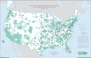
English: Metropolitan and Micropolitan Statistical Areas of the United States and Puerto Rico, 2009. High resolution vector PDF located at http://www2.census.gov/geo/maps/metroarea/us_wall/Dec_2009/cbsa_us_1209.pdf |
| Date | |
| Source | http://www2.census.gov/geo/maps/metroarea/us_wall/Dec_2009/cbsa_us_1209_large.gif |
| Author | Bureau of the Census, U.S. Department of Commerce |
| Permission (Reusing this file) |
Public domain |
Licensing[edit]
This image or file is a work of a United States Census Bureau employee, taken or made as part of that person's official duties. As a work of the U.S. federal government, the image is in the public domain.
|
 |
File history
Click on a date/time to view the file as it appeared at that time.
| Date/Time | Thumbnail | Dimensions | User | Comment | |
|---|---|---|---|---|---|
| current | 02:38, 5 August 2011 | | 4,000 × 2,571 (1.06 MB) | Huntster (talk | contribs) | Update to December 2009 data. |
| 21:15, 24 May 2011 |  | 4,028 × 2,600 (1.09 MB) | NickK (talk | contribs) | {{Information |Description={{en|Combined Statistical areas of the United States and Puerto Rico as of November 2004}} |Source=http://www.census.gov/ Transferred from uk:Файл:CBSA_US_2004.gif |Date=2004-11 |Author=Bureau of the Census, Department |
You cannot overwrite this file.
File usage on Commons
The following page uses this file:
- File:CBSA US 2004.gif (file redirect)
File usage on other wikis
The following other wikis use this file:
- Usage on en.wikipedia.org
- Usage on uk.wikipedia.org