File:Middle East. LOC 2013586103.jpg
Jump to navigation
Jump to search

Size of this preview: 800 × 502 pixels. Other resolutions: 320 × 201 pixels | 640 × 401 pixels | 1,024 × 642 pixels | 1,280 × 803 pixels | 2,560 × 1,605 pixels | 10,208 × 6,401 pixels.
Original file (10,208 × 6,401 pixels, file size: 8.92 MB, MIME type: image/jpeg)
Captions
Captions
Add a one-line explanation of what this file represents
Summary[edit]
| Description |
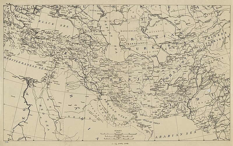
English: Shows railroads, roads and geographic divisions as they were before the end of World War I. Map centered on Iran. LC copy mounted on cloth. Available also through the Library of Congress Web site as a raster image. |
||
| Title | [Middle East]. | ||
| Shelf ID | G7420 1918 .A4 | ||
| Date | |||
| Source | https://www.loc.gov/item/2013586103/ | ||
| Author | American Geographical Society Of New York | ||
| Permission (Reusing this file) |
|
||
| Other versions |
|
||
| Location | Middle East | ||
| Part of | American Memory · General Maps · Catalog · Geography And Map Division | ||
| Subject | Maps · Railroads · Middle East · Road Maps |


Licensing[edit]
|
This is a faithful photographic reproduction of a two-dimensional, public domain work of art. The work of art itself is in the public domain for the following reason:
The official position taken by the Wikimedia Foundation is that "faithful reproductions of two-dimensional public domain works of art are public domain".
This photographic reproduction is therefore also considered to be in the public domain in the United States. In other jurisdictions, re-use of this content may be restricted; see Reuse of PD-Art photographs for details. | ||||
File history
Click on a date/time to view the file as it appeared at that time.
| Date/Time | Thumbnail | Dimensions | User | Comment | |
|---|---|---|---|---|---|
| current | 16:17, 21 May 2018 | | 10,208 × 6,401 (8.92 MB) | Fæ (talk | contribs) | LOC Maps https://www.loc.gov/item/2013586103/ #12932 |
You cannot overwrite this file.
File usage on Commons
The following 3 pages use this file:
._LOC_2013586103.jpg&redirect=no)