File:Minoan Crete topographic map-ru.svg
Jump to navigation
Jump to search

Size of this PNG preview of this SVG file: 800 × 380 pixels. Other resolutions: 320 × 152 pixels | 640 × 304 pixels | 1,024 × 486 pixels | 1,280 × 608 pixels | 2,560 × 1,215 pixels | 3,370 × 1,600 pixels.
Original file (SVG file, nominally 3,370 × 1,600 pixels, file size: 2.48 MB)
Captions
Captions
Add a one-line explanation of what this file represents
Summary[edit]
| Description |
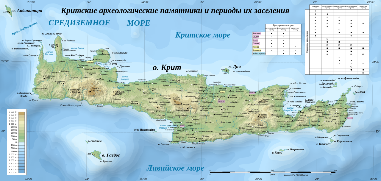
Русский: Топографическая карта острова Крит с его археологическими памятниками разных эпох |
| Date | |
| Source |
File:Crete archaeological sites-fr.svg File:Crete topographic map-ru.svg |
| Author | Eric Gaba (Sting - fr:Sting), перевод на русский (translation on russian) - Пётр Тарасьев |
| Other versions |
[]
|
| SVG development | This vector image was created with Inkscape. This file uses embedded text that can be easily translated using a text editor. |


|
This SVG file contains embedded text that can be translated into your language, using any capable SVG editor, text editor or the SVG Translate tool. For more information see: About translating SVG files. |
Licensing[edit]
I, the copyright holder of this work, hereby publish it under the following license:
This file is licensed under the Creative Commons Attribution-Share Alike 4.0 International license.
- You are free:
- to share – to copy, distribute and transmit the work
- to remix – to adapt the work
- Under the following conditions:
- attribution – You must give appropriate credit, provide a link to the license, and indicate if changes were made. You may do so in any reasonable manner, but not in any way that suggests the licensor endorses you or your use.
- share alike – If you remix, transform, or build upon the material, you must distribute your contributions under the same or compatible license as the original.
File history
Click on a date/time to view the file as it appeared at that time.
| Date/Time | Thumbnail | Dimensions | User | Comment | |
|---|---|---|---|---|---|
| current | 09:49, 2 October 2022 | | 3,370 × 1,600 (2.48 MB) | Пётр Тарасьев (talk | contribs) | Uploaded own work with UploadWizard |
You cannot overwrite this file.
File usage on Commons
The following 19 pages use this file:
- User:Magog the Ogre/Multilingual legend/2022 October 1-10
- File:Crete archaeological sites-fr.svg
- File:Crete archaeological sites-pt.svg
- File:Crete integrated map-el.svg
- File:Crete integrated map-en.svg
- File:Crete integrated map-hu.svg
- File:Crete integrated map-mk.svg
- File:Crete integrated map-ur.svg
- File:Crete relief map-be.svg
- File:Crete relief map-de.jpg
- File:Crete relief map-de.svg
- File:Crete relief map-fr.svg
- File:Crete topographic map-fr.jpg
- File:Crete topographic map-fr.svg
- File:Crete topographic map-it.svg
- File:Crete topographic map-ru.svg
- File:Crete topographic map-uk.svg
- File:Minoan Crete topographic map-ru.svg
- Template:Other versions/Crete topographic map
File usage on other wikis
The following other wikis use this file:
- Usage on ru.wikipedia.org