File:Mt Vesuvius 79 AD eruption-fr.svg
Jump to navigation
Jump to search

Size of this PNG preview of this SVG file: 652 × 396 pixels. Other resolutions: 320 × 194 pixels | 640 × 389 pixels | 1,024 × 622 pixels | 1,280 × 777 pixels | 2,560 × 1,555 pixels.
Original file (SVG file, nominally 652 × 396 pixels, file size: 113 KB)
Captions
Captions
Add a one-line explanation of what this file represents
Summary[edit]
| Description |
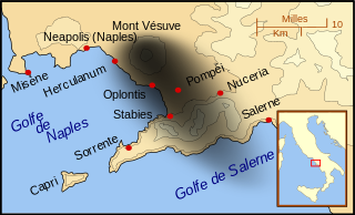
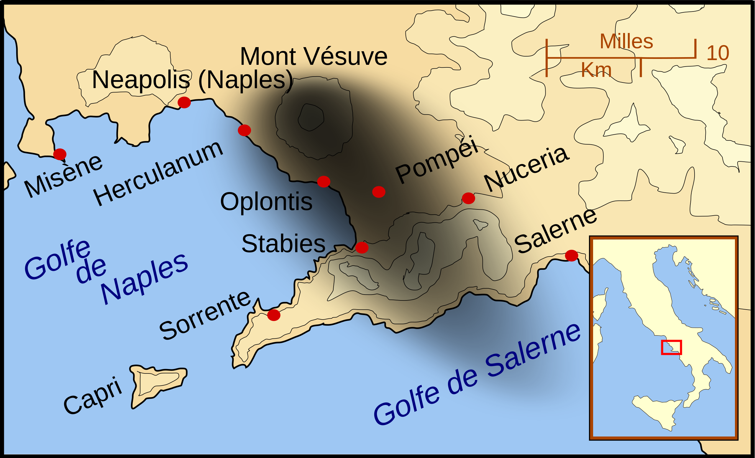
Français : Carte montrant les villes touchées par l'éruption du Vésuve en 79. Répartition générale de la pluie de cendres illustrée par la zone noirâtre au sud-est du volcan. |
| Date | |
| Source | Mt_Vesuvius_79_AD_eruption_3.svg |
| Author |
MapMaster
|
| Other versions |
[]
|


|
This SVG file contains embedded text that can be translated into your language, using any capable SVG editor, text editor or the SVG Translate tool. For more information see: About translating SVG files. |
Licensing[edit]
This file is licensed under the Creative Commons Attribution-Share Alike 3.0 Unported license.
- You are free:
- to share – to copy, distribute and transmit the work
- to remix – to adapt the work
- Under the following conditions:
- attribution – You must give appropriate credit, provide a link to the license, and indicate if changes were made. You may do so in any reasonable manner, but not in any way that suggests the licensor endorses you or your use.
- share alike – If you remix, transform, or build upon the material, you must distribute your contributions under the same or compatible license as the original.
File history
Click on a date/time to view the file as it appeared at that time.
| Date/Time | Thumbnail | Dimensions | User | Comment | |
|---|---|---|---|---|---|
| current | 06:54, 6 December 2013 | | 652 × 396 (113 KB) | Jean Marcotte (talk | contribs) | Identification de l'île de Capri |
| 15:03, 3 December 2013 |  | 652 × 396 (112 KB) | Jean Marcotte (talk | contribs) | User created page with UploadWizard |
You cannot overwrite this file.
File usage on Commons
The following 21 pages use this file:
- File:Mt Vesuvius 79 AD eruption-fr.svg
- File:Mt Vesuvius 79 AD eruption-he.svg
- File:Mt Vesuvius 79 AD eruption-la.svg
- File:Mt Vesuvius 79 AD eruption-mk.svg
- File:Mt Vesuvius 79 AD eruption-nl.svg
- File:Mt Vesuvius 79 AD eruption-ru.svg
- File:Mt Vesuvius 79 AD eruption.svg
- File:Mt Vesuvius 79 AD eruption 3 fr.svg (file redirect)
- File:Mt Vesuvius 79 AD eruption.svg
- File:Mt Vesuvius 79 AD eruption-la.svg
- File:Mt Vesuvius 79 AD eruption-he.svg
- File:Mt Vesuvius 79 AD eruption-nl.svg
- File:Mt Vesuvius 79 AD eruption-fr.svg
- File:Vesuvius 79 AD eruption Latina-pt.svg
- File:Mt Vesuvius 79 AD eruption-ru.svg
- Template:Other versions/Mt Vesuvius 79 AD eruption
- File:Mt Vesuvius 79 AD eruption ZH.svg
- File:Mt Vesuvius 79 AD eruption-mk.svg
- File:Mt Vesuvius 79 AD eruption ZH.svg
- File:Vesuvius 79 AD eruption Latina-pt.svg
- Template:Other versions/Mt Vesuvius 79 AD eruption
File usage on other wikis
The following other wikis use this file:
- Usage on br.wikipedia.org
- Usage on fr.wikipedia.org