File:My Public Lands Roadtrip- South Fork of the Snake River in BLM Idaho (18622474815).jpg

Original file (3,264 × 2,448 pixels, file size: 5.4 MB, MIME type: image/jpeg)
Captions
Captions
Summary[edit]
.jpg&action=edit§ion=1)
| Description |
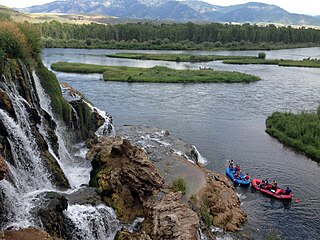
The South Fork of the Snake River flows 66 miles across southeastern Idaho, through high mountain valleys, rugged canyons, and broad flood plains to its confluence with the Henry’s Fork near Menan Buttes. Since 1985, the river has been eligible for inclusion in the nation’s Wild and Scenic River System. The South Fork supports the largest riparian cottonwood gallery forest in the West and is among the most unique and diverse ecosystems in Idaho. It is also home to 126 bird species, including 21 raptors, meriting a “National Important Bird Area” designation. The river also supports the largest native cutthroat fishery outside of Yellowstone National Park. The corridor is also home for an impressive array of other wildlife including moose, deer, elk, mountain goats, mountain lions, black bears, bobcats, coyotes, river otter, beaver, fox, and mink. Among recreationists throughout the country, the South Fork is known as a premier blue ribbon trout fishery, and was selected as the host site for the 1997 World Fly-Fishing Championship. More than 300,000 anglers, campers, hikers, boaters and other recreationists use the South Fork each year. |
| Date | |
| Source | My Public Lands Roadtrip: South Fork of the Snake River in BLM Idaho |
| Author | Bureau of Land Management |
| Camera location | | View this and other nearby images on: OpenStreetMap |
|---|
.jpg¶ms=043.440891_N_-111.377328_E_globe:Earth_type:camera_source:Flickr_&language=en)
Licensing[edit]
.jpg&action=edit§ion=2)
- You are free:
- to share – to copy, distribute and transmit the work
- to remix – to adapt the work
- Under the following conditions:
- attribution – You must give appropriate credit, provide a link to the license, and indicate if changes were made. You may do so in any reasonable manner, but not in any way that suggests the licensor endorses you or your use.
| This image was originally posted to Flickr by mypubliclands at https://flickr.com/photos/91981596@N06/18622474815. It was reviewed on 5 August 2015 by FlickreviewR and was confirmed to be licensed under the terms of the cc-by-2.0. |
| This image is a work of a Bureau of Land Management* employee, taken or made as part of that person's official duties. As a work of the U.S. federal government, the image is in the public domain in the United States. *or predecessor organization |
File history
Click on a date/time to view the file as it appeared at that time.
| Date/Time | Thumbnail | Dimensions | User | Comment | |
|---|---|---|---|---|---|
| current | 18:48, 4 August 2015 | | 3,264 × 2,448 (5.4 MB) | Wilfredor (talk | contribs) | Transferred from Flickr via Flickr2Commons |
You cannot overwrite this file.
File usage on Commons
There are no pages that use this file.
File usage on other wikis
The following other wikis use this file:
- Usage on en.wikipedia.org
.jpg&oldid=650867241)