File:Myanmar civil war.svg

Original file (SVG file, nominally 1,228 × 2,003 pixels, file size: 1.29 MB)
Captions
Captions

|
This file may be updated to reflect new information. If you wish to use a specific version of the file without new updates being mirrored, please upload the required version as a separate file. |
Summary[edit]
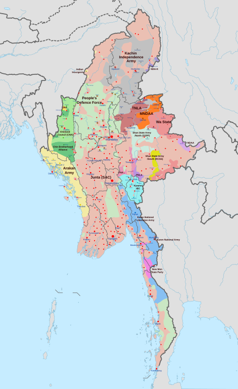
| Description |
English: A map of the Myanmar civil war (2021–present)
|
| Date | |
| Source | Own work derivate of Myanmar adm location map.svg by NordNordWest. Citing @ThomasVLinge |
| Author | Ecrusized |
| Other versions |
|

This file is translated using SVG <switch> elements. All translations are stored in the same file! Learn more.
For most Wikipedia projects, you can embed the file normally (without a To translate the text into your language, you can use the SVG Translate tool. Alternatively, you can download the file to your computer, add your translations using whatever software you're familiar with, and re-upload it with the same name. You will find help in Graphics Lab if you're not sure how to do this. |
Licensing[edit]
| This file is made available under the Creative Commons CC0 1.0 Universal Public Domain Dedication. | |
| The person who associated a work with this deed has dedicated the work to the public domain by waiving all of their rights to the work worldwide under copyright law, including all related and neighboring rights, to the extent allowed by law. You can copy, modify, distribute and perform the work, even for commercial purposes, all without asking permission.
|
File history
Click on a date/time to view the file as it appeared at that time.
| Date/Time | Thumbnail | Dimensions | User | Comment | |
|---|---|---|---|---|---|
| current | 18:46, 17 April 2024 | | 1,228 × 2,003 (1.29 MB) | EmeraldRange (talk | contribs) | Updating Myawaddy area to reflect territory taken - Shwekoko to the north and Thinganyinaung to the west as per Talk on en:Myanmar civil war (2021-present) |
| 03:01, 12 April 2024 |  | 1,228 × 2,003 (1.3 MB) | PequodOnStationAtLZ (talk | contribs) | updated to reflect rebel capture of myawaddy | |
| 20:52, 4 April 2024 |  | 1,228 × 2,003 (1.3 MB) | EmeraldRange (talk | contribs) | Updated based on Timelines , sources and new map from van Linge; see File Talk/Discusion for sources | |
| 15:35, 23 March 2024 |  | 1,228 × 2,003 (1.29 MB) | TheWasalpha (talk | contribs) | Capture of Rathedaung last week by AA, removed a misplaced dot in Bangladesh | |
| 16:47, 17 March 2024 |  | 1,228 × 2,003 (1.29 MB) | EmeraldRange (talk | contribs) | Updated with other items to March 17, see File Talk/Discussion | |
| 06:32, 16 March 2024 |  | 1,228 × 2,003 (1.27 MB) | Hoben7599 (talk | contribs) | See discussion for source links | |
| 15:12, 21 February 2024 |  | 1,228 × 2,003 (1.27 MB) | EmeraldRange (talk | contribs) | Updated to include Myebon capture, Mabein capture and AA territory updates based on source from Talk:Myanmar civil war. (See discussion for source links) | |
| 03:25, 16 February 2024 |  | 1,228 × 2,003 (1.27 MB) | EmeraldRange (talk | contribs) | fixed wrong layering for Karenni | |
| 03:14, 16 February 2024 |  | 1,228 × 2,003 (1.27 MB) | EmeraldRange (talk | contribs) | Fixed wrong layering for Karen | |
| 02:26, 16 February 2024 |  | 1,228 × 2,003 (1.27 MB) | EmeraldRange (talk | contribs) | See talk- several changes made |
You cannot overwrite this file.
File usage on Commons
More than 100 pages use this file. The following list shows the first 100 pages that use this file only. A full list is available.
- User:Hermes79
- User:Hermes7979
- File:2013 Hama Offensive.svg
- File:2015 Latakia Frontlines.svg
- File:Aleppo Offensives 2015.svg
- File:Armed conflict zones in Myanmar.png
- File:Attaques-terroristes-meurtrières-au-21eme-siecle.png
- File:Battle of Daraa City.svg
- File:Battle of Hasakah.svg
- File:Battle of Qamishli.svg
- File:Battle of Raqqa.svg
- File:Battle of Tadmur.svg
- File:Battle of Western Qalamoun.svg
- File:Battlefields in The Global War on Terror.svg
- File:Battlefields in The Global War on Terror - edit03.png
- File:Battlefields in The Global War on Terror - edit04.png
- File:Benghazi Conflict Detailed Map.png
- File:Benghazi Conflict Detailed Map.svg
- File:Boko Haram insurgency map.svg
- File:Countries by soldier count.svg
- File:Deir ez-Zor clashes (2017).svg
- File:East Congo conflict map.svg
- File:GSPC map.png
- File:ISIS (Grey) Territory Change 2014-2016.gif
- File:Iraqi Civil War map (2014–present).png
- File:Iraqi–Kurdish conflict map.png
- File:Islamist insurgency in Nigeria.svg
- File:Lebanese insurgency.png
- File:Lebanese insurgency.svg
- File:Libyan Civil War.svg
- File:Libyan war final-fr.svg
- File:Map of Ongoing conflicts around the world.png
- File:Map of terror of the Islamic State (ad-Daula al-islāmiyya).png
- File:Mexico states map small war.PNG
- File:Mosul offensive (2015) map.png
- File:Number of Terrorist Incidents.png
- File:Ongoing Conflicts (1).png
- File:Ongoing conflicts around the world.svg
- File:Pakistan-Waziristan-Map.png
- File:Political map Afar triangle.png
- File:Rif Damashq.svg
- File:Siege of Homs Map.svg
- File:Sinai insurgency.svg
- File:Somali Civil War (2009-present).svg
- File:Southern Sudan Civil War.svg
- File:Sudanese Internal Conflict.svg
- File:Syria and Iraq 2014-onward War map.png
- File:Syrian, Iraqi, and Lebanese insurgencies.png
- File:Syrian Civil War map.svg
- File:Syrian civil war.png
- File:Tadmur offensive (2015).jpg
- File:Territorial changes after 2016 Armenian-Azerbaijani clashes.jpg
- File:Turkish-PKK rebellion.svg
- File:War in North-West Pakistan.svg
- File:World2s.png
- File:Yemeni Civil War.svg
- File:Zones de conflit en Birmanie.png
- File:Саудовско-йеменский конфликт.png
- Template:Ongoing civil wars (maps)
- Category:2015 military intervention in Yemen
- Category:2016 Armenian–Azerbaijani clashes
- Category:Attack
- Category:Battle of Aleppo
- Category:Battles in 2016
- Category:Battles of Syria
- Category:Battles of the Syrian Civil War
- Category:Civil wars
- Category:Conflicts
- Category:Conflicts by continent
- Category:Conflicts by country
- Category:Conflicts by type
- Category:Current civil wars maps
- Category:Feuds
- Category:Fights
- Category:Liberation of Palmyra (2016)
- Category:Maps of Somali Civil War
- Category:Maps of conflicts
- Category:Maps of disputed territories
- Category:Maps of terrorism
- Category:Maps of the 2014 pro-Russian unrest in Ukraine
- Category:Maps of the Demilitarized Zone of Korea
- Category:Maps of the Syrian Civil War in 2016
- Category:Maps of the Syrian Civil War in 2017
- Category:Maps of the War in Afghanistan (2001–2021)
- Category:Maps of wars
- Category:Military conflicts
- Category:Military maps of the world
- Category:Ongoing armed conflicts
- Category:Palmyra offensive (December 2016)
- Category:Quarrels
- Category:Rebellions
- Category:Riots
- Category:Schisms
- Category:Syrian Civil War
- Category:Terrorism
- Category:Uprisings
- Category:War
- Category:War casualties
- Category:Warfare by type
- Category:Wars
.svg)
_Territory_Change_2014-2016.gif)
.png)
.png)
_map.png)
.png)
.svg)
.jpg)
View more links to this file.
File usage on other wikis
The following other wikis use this file:
- Usage on ar.wikipedia.org
- Usage on de.wikipedia.org
- Usage on en.wikipedia.org
- Usage on es.wikipedia.org
- Usage on et.wikipedia.org
- Usage on fa.wikipedia.org
- Usage on fr.wikipedia.org
- Usage on hu.wikipedia.org
- Usage on it.wikipedia.org
- Usage on ko.wikipedia.org
- Usage on my.wikipedia.org
- Usage on pt.wikipedia.org
- Usage on ru.wikipedia.org
- Usage on th.wikipedia.org
- Usage on uk.wikipedia.org
- Usage on zh.wikipedia.org