File:Nile River (MODIS 2022-01-26).jpg

Original file (1,838 × 1,443 pixels, file size: 243 KB, MIME type: image/jpeg)
Captions
Captions
Summary[edit]
.jpg&action=edit§ion=1)
| Description |
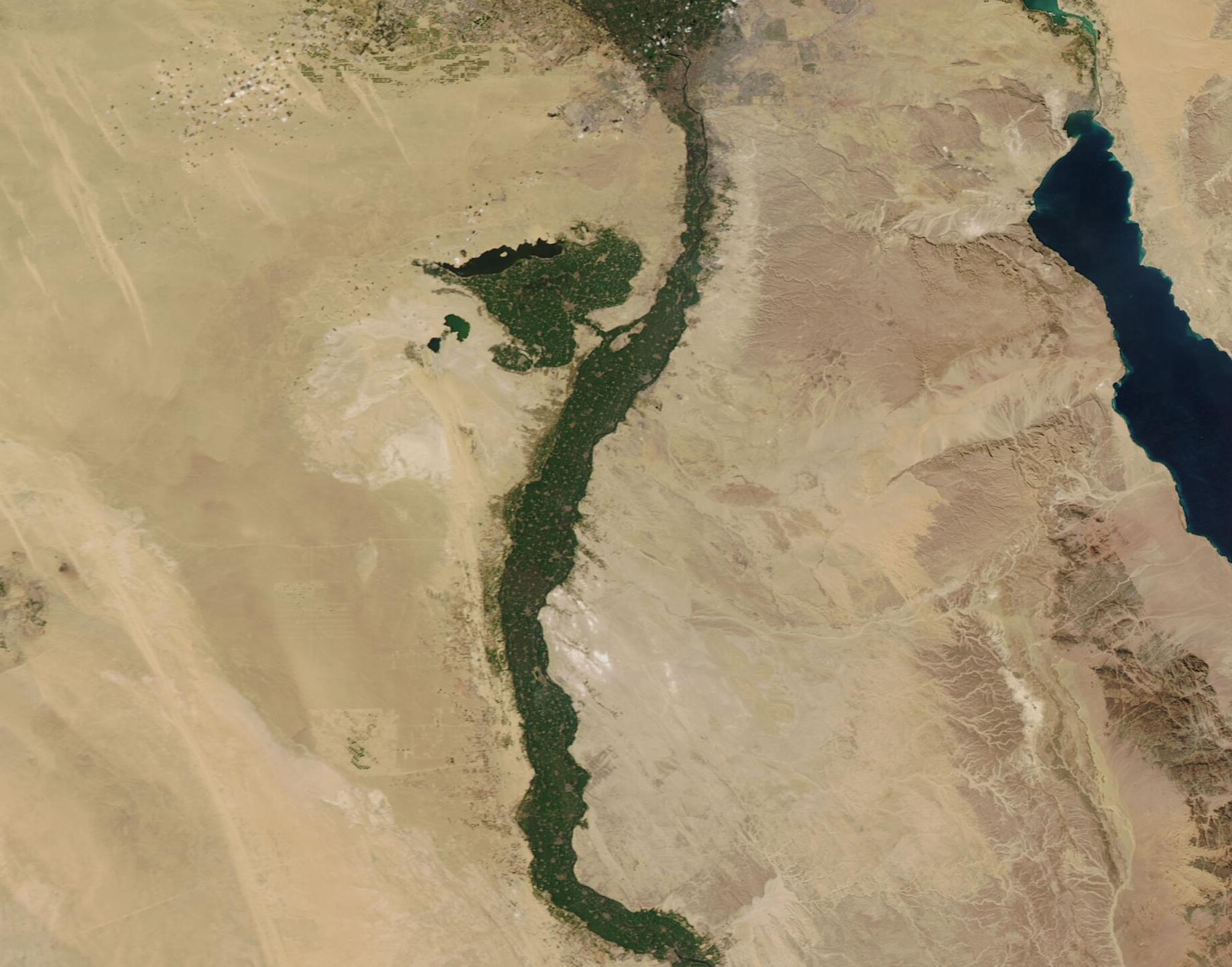
English: On January 25, 2022, the Moderate Resolution Imaging Spectroradiometer (MODIS) on board NASA’s Aqua satellite acquired a true-color image of the Nile River as it winds through the arid lands of Egypt. Near the top (north) of the image, the gray pixels at base of the Nile River Delta mark the large city of Cairo. The city is located about 100 miles south of where the Nile’s waters spill into the Mediterranean Sea. West of the Nile sits the Faiyum Oasis, with the green fields watered by a channel of the broad Nile River.
The Nile River is the longest river in the world, extending about 6,700 kilometers (4,160 miles) from its headwaters in the highland of eastern Africa to the shores of the Mediterranean Sea. The fertile soils along the Nile River support the country’s agriculture, as well as providing home for 95 percent of Egypt’s population. Only 4 percent of Egypt’s land is suitable for agriculture, and that number is shrinking quickly due to a wave of urban and suburban development that accompanies an expanding population. In December 2021, NASA’s Earth Observatory quoted Nasem Badreldin, a digital agronomist at the University of Manitoba, who said, “Satellite data shows us that Egypt is losing about 2 percent of its arable land per decade due to urbanization, and the process is accelerating. If this continues, Egypt will face serious food security problems.” The success of agriculture here, as everywhere, depends on a plentiful and reliable supply of water. The Nile River has long proven generally reliable, despite flooding and dry times. As the population increases along the entire Nile, more and more water is being utilized nearer the headwaters, with less water tending to reach the Nile Delta. A warming climate and increasing periods of drought also threaten to limit the water available in Egypt’s Nile region. On January 25, water appears to be plentiful in the Nile and the surrounding floodplains are green, thanks to recent rains. In May 2021, however, northern Egypt was suffering from drought conditions, with the Nile’s waters much reduced, despite adequate rain in the south. The NASA Worldview App allows a roll-over comparison between two Aqua MODIS images captured on January 25, 2022, and May 25, 2021. To view that comparison, click here. |
||
| Date | Taken on 25 January 2022 | ||
| Source |
|
||
| Author | MODIS Land Rapid Response Team, NASA GSFC |
| This media is a product of the Aqua mission Credit and attribution belongs to the mission team, if not already specified in the "author" row |
Licensing[edit]
.jpg&action=edit§ion=2)
| This file is in the public domain in the United States because it was solely created by NASA. NASA copyright policy states that "NASA material is not protected by copyright unless noted". (See Template:PD-USGov, NASA copyright policy page or JPL Image Use Policy.) | ||
 |
Warnings:
|
File history
Click on a date/time to view the file as it appeared at that time.
| Date/Time | Thumbnail | Dimensions | User | Comment | |
|---|---|---|---|---|---|
| current | 22:20, 9 January 2024 | | 1,838 × 1,443 (243 KB) | OptimusPrimeBot (talk | contribs) | #Spacemedia - Upload of http://modis.gsfc.nasa.gov/gallery/images/image01262022_250m.jpg via Commons:Spacemedia |
You cannot overwrite this file.
File usage on Commons
There are no pages that use this file.
.jpg&oldid=840107752)