File:Operations in the Karapoch Country (Nandi). (WOMAT-AFR-BEA-104).jpg
Jump to navigation
Jump to search

Size of this preview: 800 × 536 pixels. Other resolutions: 320 × 215 pixels | 640 × 429 pixels | 1,024 × 687 pixels | 1,280 × 858 pixels | 2,560 × 1,717 pixels | 10,351 × 6,941 pixels.
Original file (10,351 × 6,941 pixels, file size: 29.5 MB, MIME type: image/jpeg)
Captions
Captions
Add a one-line explanation of what this file represents
Summary[edit]
; ;
| Title |
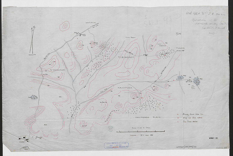
'Operations in the Karapoch Country (Nandi). Capt. Ward & Lt. Bennett Nov/03' |
|||||||||
| Description |
Shows an area in East Africa Protectorate north-east of Kisumu, occupied by the Kakapoch, one of 15 geographically distributed groups belonging to the Nandi tribe. The map indicates vegetation, relief with form lines, hydrology, settlements, habitations and a cart track. Also records the route of a military expedition, with locations and descriptions of events. |
|||||||||
| British Library Shelfmark | WOMAT/AFR/BEA/104 | |||||||||
| Locations Depicted | Kisumu, Kenya ; Nandi, Kenya | |||||||||
| Centre Point Coordinates | 0.0182,34.8781 | |||||||||
| Date | ||||||||||
| Source |
|
|||||||||
| Creator |
Bennett, Ernest Edward Sebastian, 1879-1906, army officer, Surveyor Ward, Lancelot Edward Seth, 1875-1929, army officer, Surveyor |
|||||||||
| Permission (Reusing this file) |
|
|||||||||
| Geotemporal data | ||||||||||
| Map location | British East Africa | |||||||||
| Scale | 1:63,360 | |||||||||
| Bounding box |
|
|||||||||
| Georeferencing | If inappropriate please set warp_status = skip to hide. | |||||||||
| Archival data | ||||||||||
| Collection | ||||||||||
| Dimensions | 40 x 64cm | |||||||||
| Medium | Manuscript: coloured ink, pencil and watercolour on tracing linen | |||||||||
| Notes | For more information please see the British Library’s Collection Guide to the War Office Archive. Archived from the original on 2016-01-11. Retrieved on 2015-11-23. | |||||||||

_(St_Edwards_Crown).svg)


._(WOMAT-AFR-BEA-104).jpg&action=edit§ion=1)
._(WOMAT-AFR-BEA-104).jpg¶ms=0.0979_N_34.7661_E_)
._(WOMAT-AFR-BEA-104).jpg¶ms=0.0979_N_34.9902_E_)
._(WOMAT-AFR-BEA-104).jpg¶ms=-0.0615_N_34.7661_E_)
._(WOMAT-AFR-BEA-104).jpg¶ms=-0.0615_N_34.9902_E_)
File history
Click on a date/time to view the file as it appeared at that time.
| Date/Time | Thumbnail | Dimensions | User | Comment | |
|---|---|---|---|---|---|
| current | 18:37, 23 November 2015 | | 10,351 × 6,941 (29.5 MB) | Ndalyrose (talk | contribs) | GWToolset: Creating mediafile for Ndalyrose. |
You cannot overwrite this file.
File usage on Commons
There are no pages that use this file.
._(WOMAT-AFR-BEA-104).jpg&oldid=855255877)