File:Ordnance Survey Drawings - Frome (OSD 59).jpg
Jump to navigation
Jump to search

Size of this preview: 316 × 600 pixels. Other resolutions: 126 × 240 pixels | 253 × 480 pixels | 405 × 768 pixels | 539 × 1,024 pixels | 1,079 × 2,048 pixels | 3,062 × 5,810 pixels.
Original file (3,062 × 5,810 pixels, file size: 4.42 MB, MIME type: image/jpeg)
Captions
Captions
Add a one-line explanation of what this file represents
| Frome (OSD 59)
|
|||||
|---|---|---|---|---|---|
| Artist |
[Crocker, Edmund] - Draughtsman |
.jpg) | |||
| Title |
Ordnance Survey Drawings: Frome (OSD 59) |
||||
| Object type |
manuscript map |
||||
| Description |
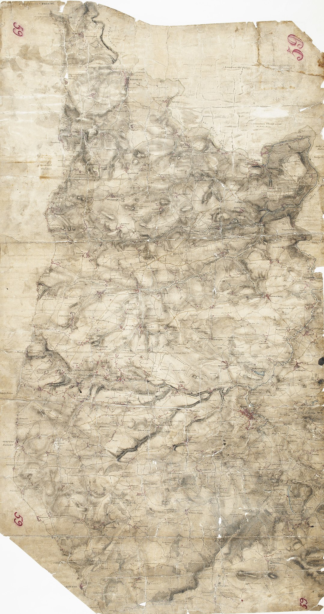
 Centre of map shown on a map of England
English: This drawing highlights Bath and the River Avon. Major communication routes are coloured yellow/buff, according to military cartographic convention. Shading and 'hachuring' denote relief and give an overall impression of the undulating landscape. The Somerset Coal Canal is clearly visible leading into Bath. It was established by Act of Parliament in 1794 and welcomed by the mine owners of north Somerset as a cheaper way of transporting coal to Bath and the surrounding areas, curbing fears of an influx of Welsh coal. The canal was one of the most successful in the country, carrying over 100,000 tons of coal per year. That success was to be checked, however, by the expansion of the local rail network, in particular, the opening of the line between Radstock and Frome, which hastened the canal's closure in 1898. At the time of this survey, the canal was fully operational..
This image has been georeferenced.
|
||||
| Language |
English |
||||
| Date | 1808 | ||||
| Medium | Pen and ink on paper | ||||
| Dimensions | height: 530 mm (20.86 in); width: 290 mm (11.41 in) | ||||
| Collection | |||||
| Accession number |
Maps OSD 59 |
||||
| Credit line | British Library | ||||
| Notes |
Scale 2 inches : 1 mile ( 1: 31680). Please note that the British Library provides these digital files "as-is"; materials will not be rephotographed under this programme. If resupply of files is required, the requestor will be required to purchase them at the standard rate. |
||||
| References |
http://www.bl.uk/onlinegallery/onlineex/ordsurvdraw/f/002osd000000019u00044000.html (English) |
||||
| Source/Photographer |
|
||||
| Permission (Reusing this file) |
|
||||


_(St_Edwards_Crown).svg)
.jpg¶ms=51.284417_N_-2.424036_E_)
.jpg¶ms=51.08861_N_-2.627954_E_)
.jpg¶ms=51.480224_N_-2.220117_E_)
.jpg¶ms=51.446083_N_-2.627954_E_)
.jpg¶ms=51.08861_N_-2.521094_E_)
.jpg¶ms=51.122751_N_-2.220117_E_)
.jpg¶ms=51.480224_N_-2.326978_E_)
File history
Click on a date/time to view the file as it appeared at that time.
| Date/Time | Thumbnail | Dimensions | User | Comment | |
|---|---|---|---|---|---|
| current | 21:53, 26 September 2013 | | 3,062 × 5,810 (4.42 MB) | LibraryBot (talk | contribs) | {{subst:User:Andrew Gray/OSD|ID= 002OSD000000019U00044000 |OSD_NUM= OSD 59 |MEDIUM= Pen and ink on paper |TITLE= Frome |CREATOR= [Crocker, Edmund] - Draughtsman |YEAR= 1808 |DESCRIPTION= This drawing highlights Bath and the River Avon. Major communicat... |
You cannot overwrite this file.
File usage on Commons
The following page uses this file:
File usage on other wikis
The following other wikis use this file:
- Usage on www.wikidata.org
.jpg&oldid=713431218)