File:Ottawaexpands.png
Jump to navigation
Jump to search

Size of this preview: 800 × 593 pixels. Other resolutions: 320 × 237 pixels | 640 × 475 pixels | 1,024 × 759 pixels | 1,280 × 949 pixels | 1,591 × 1,180 pixels.
Original file (1,591 × 1,180 pixels, file size: 49 KB, MIME type: image/png)
Captions
Captions
Add a one-line explanation of what this file represents
Summary[edit]
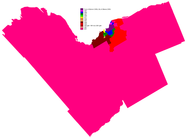
Originally uploaded to english wiki as en:Image:Ottawaexpands.png by creator en:User:Earl Andrew on November 25, 2004 This map shows the gradual incorporation of different municipalities into the city of Ottawa. Released by author to the public domain.

|
This historical map image could be re-created using vector graphics as an SVG file. This has several advantages; see Commons:Media for cleanup for more information. If an SVG form of this image is available, please upload it and afterwards replace this template with
{{vector version available|new image name}}.
It is recommended to name the SVG file “Ottawaexpands.svg”—then the template Vector version available (or Vva) does not need the new image name parameter. |
Licensing[edit]
Note: This tag is deprecated, please replace this template with {{PD-user-w}}
| |
This work has been released into the public domain by its author, Earl Andrew, at the English Wikipedia project. This applies worldwide. In case this is not legally possible: |
File history
Click on a date/time to view the file as it appeared at that time.
| Date/Time | Thumbnail | Dimensions | User | Comment | |
|---|---|---|---|---|---|
| current | 09:04, 1 May 2005 | | 1,591 × 1,180 (49 KB) | Peregrine981 (talk | contribs) | Originally uploaded to english wiki as en:Image:Ottawaexpands.png by creator en:User:Earl Andrew on November 25, 2004 This map shows the gradual incorporation of different municipalities into the city of Ottawa. Released by author to the public |
You cannot overwrite this file.
File usage on Commons
The following page uses this file:
File usage on other wikis
The following other wikis use this file:
- Usage on ast.wikipedia.org
- Usage on en.wikipedia.org
- Usage on es.wikipedia.org
- Usage on ru.wikipedia.org
- Usage on uz.wikipedia.org
- Usage on vi.wikipedia.org