File:PIA21265 - Blade-Like Martian Walls Outline Polygons (Stereo).jpg

Original file (1,062 × 1,855 pixels, file size: 323 KB, MIME type: image/jpeg)
Captions
Captions
Summary
[edit]| Description |
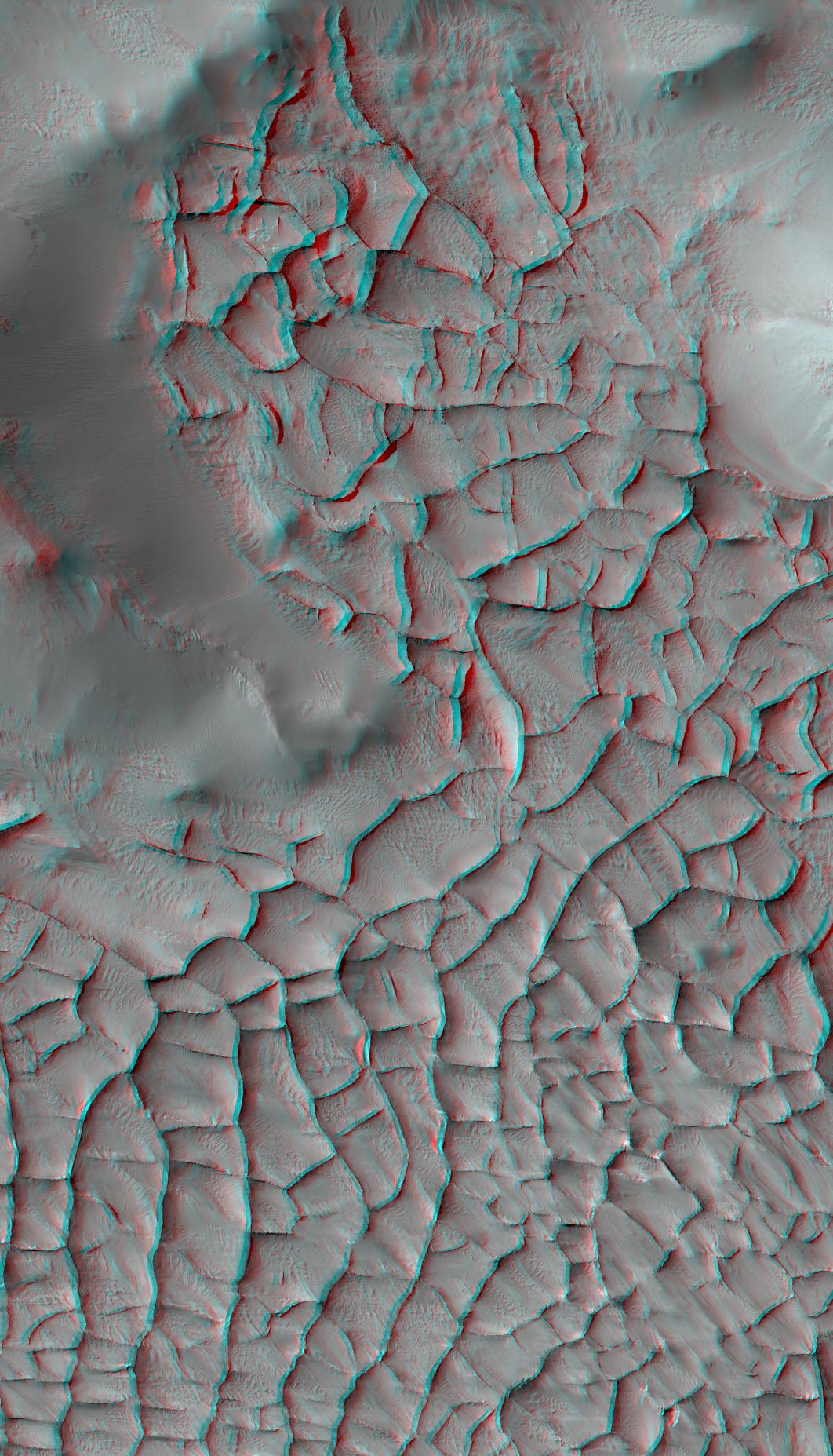
English: This stereo view shows part of an area on Mars where narrow rock ridges, some as tall as a 16-story building, intersect at angles forming corners of polygons. It appears three-dimensional when viewed through red-blue glasses with the red lens on the left.
The area covered in the image is about 1.9 miles (3 kilometers) wide, in the Gordii Dorsum portion of the Medusae Fossae region of Mars. This stereo view combines two observations from the High Resolution Imaging Science Experiment (HiRISE) camera on the Mars Reconnaissance Orbiter. Figure 1 is the left-eye image, from HiRISE observation ESP_018548_1910. Figure 2 is the right-eye image, from HiRISE observation ESP_017348_1910. The location is 10.8 degrees north latitude, 212.2 degrees east longitude. North is up. Note the afternoon shadows cast by some of the walls. These ridges likely formed as lava that hardened underground and later resisted erosion better than the surrounding material. From ground level, they would resemble hardened-lava walls on Earth such as in the image at PIA21266. The University of Arizona, Tucson, operates HiRISE, which was built by Ball Aerospace & Technologies Corp., Boulder, Colorado. NASA's Jet Propulsion Laboratory, a division of Caltech in Pasadena, California, manages the Mars Reconnaissance Orbiter Project for NASA's Science Mission Directorate, Washington. Lockheed Martin Space Systems, Denver, built the orbiter and collaborates with JPL to operate it. |
| Date | 9 April 2010 (published 25 January 2017) |
| Source | Catalog page · Full-res (JPEG · TIFF) |
| Author | NASA/JPL-Caltech/Univ. of Arizona |
| Other versions |
|
.jpg)
,_Figure_1.jpg)
,_Figure_2.jpg)
.jpg&action=edit§ion=1)
| Location on Mars | View this and other nearby images on: Google Maps |
|---|
.jpg¶ms=010.784000_N_-147.827000_E_globe:Mars__&language=en)
This image or video was catalogued by Jet Propulsion Laboratory of the United States National Aeronautics and Space Administration (NASA) under Photo ID: PIA21265. This tag does not indicate the copyright status of the attached work. A normal copyright tag is still required. See Commons:Licensing. Other languages:
|
 |
This media is a product of the Mars Reconnaissance Orbiter mission Credit and attribution belongs to the High Resolution Imaging Science Experiment (HiRISE) team, NASA/JPL-Caltech/Univ. of Arizona |
 |
This file is a stereogram. Stereograms are stereoscopic images or animations which combine left and right frames showing slightly different visual angles to allow for 3D perception.
3D red-cyan glasses are recommended to view this image correctly. |
|---|
Licensing
[edit].jpg&action=edit§ion=2)
| This file is in the public domain in the United States because it was solely created by NASA. NASA copyright policy states that "NASA material is not protected by copyright unless noted". (See Template:PD-USGov, NASA copyright policy page or JPL Image Use Policy.) | ||
 |
Warnings:
|
File history
Click on a date/time to view the file as it appeared at that time.
| Date/Time | Thumbnail | Dimensions | User | Comment | |
|---|---|---|---|---|---|
| current | 09:49, 26 January 2017 | | 1,062 × 1,855 (323 KB) | PhilipTerryGraham (talk | contribs) | User created page with UploadWizard |
You cannot overwrite this file.
File usage on Commons
The following 4 pages use this file:
.jpg&oldid=239235297)