File:PIA22078-Mars-UndergroundIceExposed-MRO-20110507.jpg

Original file (951 × 900 pixels, file size: 799 KB, MIME type: image/jpeg)
Captions
Captions
Summary[edit]
| Description |
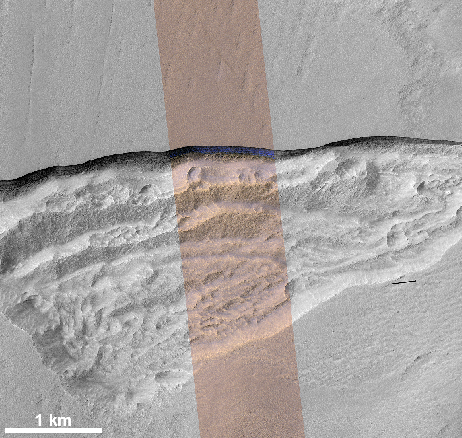
English: PIA22078: Pit Where a Scarp Exposes an Underground Deposit of Martian Ice
https://photojournal.jpl.nasa.gov/catalog/PIA22078 At this wedge-shaped pit on Mars, the steep slope (or scarp) at the northern edge (toward the top of the image) exposes a cross-section of a thick sheet of underground water ice. The image is from the High Resolution Imaging Stereo Experiment (HiRISE) camera on NASA's Mars Reconnaissance Orbiter. The gray-scale portions on left and right are from a single waveband in the red-light portion of the visible spectrum. The middle section, in enhanced color, combines data from red, near-infrared and blue-green wavebands. The scene covers an area about three miles (five kilometers) wide. Figure 1 includes a one-kilometer scale bar. One kilometer is about six-tenths of a mile. The ice-exposing scarp at the northern edge of the pit has a steepness of about 45 to 55 degrees, plunging from the relatively level ground outside the pit. A zoomed-in view showing more detail of the scarp is at PIA22077. Both views are products from HiRISE observation ESP_022389_1230, made on May 7, 2011, at 56.6 degrees south latitude, 114.1 degrees east longitude. In January 2018, in the journal Science, researchers reported finding and studying eight such ice-exposing scarps in the middle latitudes of Mars. The presence of vast underground ice deposits in Mars' middle latitudes was known previously. The report of unusual sites where they are exposed provides new information about their depth and layering. It also identifies potential water resources for future Mars missions and possibilities for studying Martian climate history by examining the ice layers holding a record of past climate cycles. The ice may have been deposited as snow when the tilt of Mars' rotation axis was greater than it is now. The University of Arizona, Tucson, operates HiRISE, which was built by Ball Aerospace & Technologies Corp., Boulder, Colorado. NASA's Jet Propulsion Laboratory, a division of Caltech in Pasadena, California, manages the Mars Reconnaissance Orbiter Project for NASA's Science Mission Directorate, Washington. |
| Date | Taken on 7 May 2011 |
| Source | https://photojournal.jpl.nasa.gov/figures/PIA22078_fig1.jpg |
| Author | NASA/JPL-Caltech/UA/USGS |
| Other versions |
|

This image or video was catalogued by Jet Propulsion Laboratory of the United States National Aeronautics and Space Administration (NASA) under Photo ID: PIA22078. This tag does not indicate the copyright status of the attached work. A normal copyright tag is still required. See Commons:Licensing. Other languages:
|
Licensing[edit]
| This file is in the public domain in the United States because it was solely created by NASA. NASA copyright policy states that "NASA material is not protected by copyright unless noted". (See Template:PD-USGov, NASA copyright policy page or JPL Image Use Policy.) | ||
 |
Warnings:
|
File history
Click on a date/time to view the file as it appeared at that time.
| Date/Time | Thumbnail | Dimensions | User | Comment | |
|---|---|---|---|---|---|
| current | 13:44, 12 January 2018 | | 951 × 900 (799 KB) | Drbogdan (talk | contribs) | User created page with UploadWizard |
You cannot overwrite this file.
File usage on Commons
The following 4 pages use this file: