File:Pakistan NWFP FATA areas with localisation map de.svg
Jump to navigation
Jump to search

Size of this PNG preview of this SVG file: 542 × 600 pixels. Other resolutions: 217 × 240 pixels | 434 × 480 pixels | 694 × 768 pixels | 925 × 1,024 pixels | 1,851 × 2,048 pixels | 1,015 × 1,123 pixels.
Original file (SVG file, nominally 1,015 × 1,123 pixels, file size: 141 KB)
Captions
Captions
Add a one-line explanation of what this file represents
| Description |
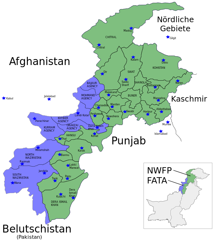
Deutsch: Karte der Stammesgebiete unter Bundesverwaltung (Federally Administered Tribal Areas, FATA) innerhalb der Nordwestlichen Grenzprovinz (North-West Frontier Province, NWFP) in Pakistan.
English: Map showing the districts of the Federally Administered Tribal Areas (FATA) FATA and the North-West Frontier Province (NWFP) of Pakistan. Español: Mapa de las provincias y territorios de Pakistán Français : Carte des régions tribales du Pakistan (FATA) et de la province voisine de Khyber Pakhtunkhwa (NWFP) |
| Date | (UTC) |
| Source | |
| Author |
|
| This is a retouched picture, which means that it has been digitally altered from its original version. Modifications: Deutsche Übersetzung / German translation. The original can be viewed here: Pakistan NWFP FATA areas with localisation map.svg:
|
I, the copyright holder of this work, hereby publish it under the following licenses:
This file is licensed under the Creative Commons Attribution-Share Alike 2.5 Generic, 2.0 Generic and 1.0 Generic license.
- You are free:
- to share – to copy, distribute and transmit the work
- to remix – to adapt the work
- Under the following conditions:
- attribution – You must give appropriate credit, provide a link to the license, and indicate if changes were made. You may do so in any reasonable manner, but not in any way that suggests the licensor endorses you or your use.
- share alike – If you remix, transform, or build upon the material, you must distribute your contributions under the same or compatible license as the original.
| This file is licensed under the Creative Commons Attribution-Share Alike 3.0 Unported license. | ||
| ||
| This licensing tag was added to this file as part of the GFDL licensing update. |

|
Permission is granted to copy, distribute and/or modify this document under the terms of the GNU Free Documentation License, Version 1.2 or any later version published by the Free Software Foundation; with no Invariant Sections, no Front-Cover Texts, and no Back-Cover Texts. A copy of the license is included in the section entitled GNU Free Documentation License. |
You may select the license of your choice.
Original upload log[edit]
This image is a derivative work of the following images:
- File:Pakistan_NWFP_FATA_areas_with_localisation_map.svg licensed with Cc-by-sa-2.5,2.0,1.0, Cc-by-sa-3.0-migrated, GFDL
- 2010-05-15T16:55:47Z Pethrus 1000x1075 (236350 Bytes) {{Information |Description={{en|Map showing the districts of the Federally Administered Tribal Areas (FATA) FATA and the North-West Frontier Province (NWFP) of Pakistan.}} {{es|Mapa de las provincias y territorios de Pakistá
Uploaded with derivativeFX
File history
Click on a date/time to view the file as it appeared at that time.
| Date/Time | Thumbnail | Dimensions | User | Comment | |
|---|---|---|---|---|---|
| current | 22:57, 17 November 2010 | | 1,015 × 1,123 (141 KB) | Furfur (talk | contribs) | kosmetik |
| 22:53, 17 November 2010 |  | 1,000 × 1,125 (142 KB) | Furfur (talk | contribs) | Fehlerkorrektur | |
| 18:12, 15 May 2010 |  | 1,000 × 1,075 (141 KB) | Furfur (talk | contribs) | kosmetsche Änderungen | |
| 18:08, 15 May 2010 |  | 1,000 × 1,075 (141 KB) | Furfur (talk | contribs) | {{Information |Description={{de|Karte der Stammesgebiete unter Bundesverwaltung (Federally Administered Tribal Areas, FATA) innerhalb der Nordwestlichen Grenzprovinz (North-West Frontier Province, NWFP) in Pak |
You cannot overwrite this file.
File usage on Commons
There are no pages that use this file.
File usage on other wikis
The following other wikis use this file:
- Usage on de.wikipedia.org
- Usage on de.wikivoyage.org