File:Palm Islands Queensland map en.png
Jump to navigation
Jump to search
No higher resolution available.
Palm_Islands_Queensland_map_en.png (563 × 595 pixels, file size: 660 KB, MIME type: image/png)
Captions
Captions
Add a one-line explanation of what this file represents
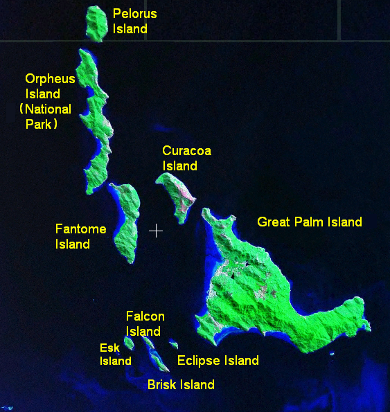
| Description | Annotated aerial map of the Palm Islands near Queensland, Australia. This is the complete Palm Islands group, according to [1] & [2] (both are Queensland government documents). |
| Date | |
| Source | Screenshot of NASA's WorldWind program. Names added by me using MS Paint based on Google Maps' names |
| Author | me (pfctdayelise (说什么?)) |
| Other versions | Image:Palm Islands Queensland map blank.png (no name labels) |
| This image is in the public domain because it is a screenshot from NASA’s globe software World Wind using a public domain layer, such as Blue Marble, MODIS, Landsat, SRTM, USGS or GLOBE.
|
 |
File history
Click on a date/time to view the file as it appeared at that time.
| Date/Time | Thumbnail | Dimensions | User | Comment | |
|---|---|---|---|---|---|
| current | 13:13, 29 January 2007 | | 563 × 595 (660 KB) | Pfctdayelise (talk | contribs) | more accurate, extra name |
| 12:51, 29 January 2007 |  | 988 × 670 (1.47 MB) | Pfctdayelise (talk | contribs) | {{Information |Description=Annotated aerial map of the Palm Islands near Queensland, Australia. |Source=Screenshot of NASA's WorldWind program. Names added by me using MS Paint based on [http://maps.google.com/maps?ll=-18.733333,146.583333&spn=0.02,0.02&q |
You cannot overwrite this file.
File usage on Commons
There are no pages that use this file.
File usage on other wikis
The following other wikis use this file:
- Usage on en.wikipedia.org